In the meantime, already there's a small moment for that queasy, sinking feeling.
 |
| From the "Draft Transportation Issues Booklet" and the "opportunities" map |
option to avoid the split [at Liberty and Commercial] by directing [south-bound] bicyclists onto Liberty Rd S until Vista Ave SE where bicyclists can connect back onto Commercial St SEBut we already did this!!!
 |
| Left turn signed at Liberty and Vista, 2009 |
The only problem? This is totally non-intuitive and very few people do it this way.
In fact, when we did a bike count at this site back in 2009, we found:
- Over 80% of cyclists proceeding south on Commercial SE choose to merge across two lanes of auto traffic turning right onto Liberty S.
- About 30% of all cyclists used the sidewalk for some or all of their movement through this complicated intersection.
We have tried this, and it doesn't work because it is non-intuitive, it is complicated, it doesn't increase comfort, and by an inconvenient bicyclist- and pedestrian-displacement system it overly accommodates the autoist firehouse.
 |
| Scary, but intuitive and direct: Hide, then scamper City Traffic Camera, Commercial at Fairview |
The junction is bad because it is confusing and unclear. The vast majority of cyclists make the intuitive move to continue on Commercial SE. They miss or ignore the signed bike movement and choose a dangerous and illegal merge whose prohibition is signed. But with the bike lane marking the messaging is incoherent.We need something completely different.
All this adds up to confusion. Consequently, bicyclists do not move through the intersection in a predictable and safe pattern. And although it's a major connection to south Salem, few bicyclists use it.
Ugh.
So. Course-correction time.
 |
| Traffic Calming would also be helpful: Drivers overcorrect hugging and crossing into the bike lane on the inside curve This was the worst, but it was observed regularly City Traffic Camera, Commercial at Fairview |
Focus on Car-Dependent Redevelopment?
It is interesting also to see the "land use" opportunities map. All the land here is underdeveloped, with too much surface area devoted to cars, their storage and movement. But even below this low-rise strip development, there's a group of vacant or even lower-density nothingness that should be redeveloped.
I hope the project doesn't get side-tracked with too much talk about jump-starting redevelopment on things like the Safeway parcel and its parking lot, and forget about making it easier to walk and bike to LifeSource, Venti's, and Acme.
 |
| Vacant big box - former Safeway on Middle Commercial |
 |
| Mid-rise downtown development generates 10x property tax/acre over suburban big box sprawl (see here for discussion and image credit) |
 |
| Road with 1980s standard bike lane - still stroady |
 |
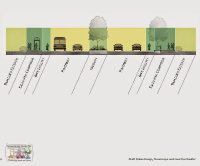
| A Nelson/Nygaard proposal from the helpful Stroad to Boulevard tumblr |
The City's project website is here, and notes on middle Commercial and the study here.


2 comments:
inserted a couple of clips from the traffic camera
and updated with inline links to the two reports
Post a Comment