Monday, April 30, 2018

Talk on Diesel Pollution Tonight

From the event description:
Join Latinos Unidos Siempre and Oregon Environmental Council in their presentation about Diesel Pollution in Salem.

Since January, two youth Project Interns Casandra Sanchez-Soriano and Antonio Muñoz, studied the levels of Diesel Pollution in Salem, and engaged their community in the process. Join us in their effort to present this information to the community.

During the presentation we will cover;
-Narratives from the community
-Black carbon levels in different communities of Salem

We will have
-Food and Childcare at no cost
The talk is at Latinos Unidos Siempre, 3850 Portland Rd NE.

You might remember a while back an OPB story on the Volkswagen scandal. It had a searchable map of particulate levels and showed problem areas in Salem, including the I-5 corridor.
Diesel Pollution in Salem - via OPB

Saturday, April 28, 2018

Congestion Relief Task Force already Skews to a Preferred Outcome

Earlier this week the Congestion Relief Task Force met and if there was one image that encapsulated its perspective and its peril, the graph of traffic counts on the bridges is a strong candidate.

Terrible increases!!!
A reader already commented on the selection of end-points to make a case for a tremendous growth in traffic. The consultant team says that traffic "has increased 12% from 2011 to 2016, or an average of 2.3% per year."

Well, that's true enough. But is it just a kind of data-hacking to find the most convenient set of facts that supports a preferred outcome? Is there a different observation that is actually more meaningful?

But how should we interpret the data? What end-points to use?
Traffic engineering operates on this model with an assumption that car traffic is always and everywhere increasing.

It's seemingly the natural order of things and we must accommodate it.

Thursday, April 26, 2018

Bike Rental Launches, Monster Cookie, Bike More Challenge - Newsbits

Wheeling season is here, and there's a lot of activity cranking up just now. Some of the big pieces are new bike rental programs. There's also the Monster Cookie this weekend, and next month is Bike Month with a rodeo at North and the Bike More Challenge statewide.

Eugene Bike Rental Program PeaceHealthRides - via Twitter
Eugene's bike share program - like with "ride share" it's a kind of rental and hire, not a sharing program, so it may be that "ride rental" is a better descriptor - launched this past week, and that will be interesting to watch.

You may remember how they snuck into the ConnectOregon program and ruffled some feathers, which resulted in some rule changes on project eligibility, but nonetheless secured funding for 300 bikes.

They've also got a significant title sponsor in the Peacehealth system.

Adoption by students at the University will determine a great proportion of its success.

It will be interesting to see how people actually use it.

Docking Station at the Hult Center on 6th Ave
A reader sent in an image of the docking stations* on the north side of the Hult Center. While the Hult is a lovely auditorium, it is the product of old-school urban renewal sandwiched between two very zoomy stroads, the 6th/7th Ave one-way couplet. Neither 6th nor 7th has bike lanes, so this docking station is not positioned for any direct east-west travel. The designated bikeways are on 5th and 8th. It's also in an awkward island between the road and a taxi waiting area for the hotel and auditorium. (* Update and correction: The bike provider, Social Bicycles, actually uses a "dockless" system, so it is not correct to call this a docking station.)

Wednesday, April 25, 2018

Budget Committee meets Tonight on Capital Improvement Plan

The Budget Committee meets tonight and they'll hold a Public Hearing on the Capital Improvement Plan for 2019-2023.


A draft proposed 2019 Capital Improvement Plan came out at the April 9th Council meeting, but there hasn't been much talk about it. Most of the decisions, too, were made long before the Strategic Plan was adopted. It will take a few cycles for everything to catch up and begin to work together.  On the CIP itself, I'm not sure the Budget Committee really has very much discretion. So the "public hearing" seems more for courtesy and to satisfy process than something intended to elicit substantive debate and analysis.

In the way it's organized, it's also hard to see the shape of underlying priorities and strategies, but maybe some things are visible.

Lots of funding from property taxes here, little from gas tax
or other auto user fees
Every year, Council and the Committee have an opportunity to talk more about ways we subsidize our roads from funding sources other than the gas tax, and auto user fees like licensing, registration, and titling. Funds associated with the valuation of property are a very large source and represent a transfer from home value to road value.

Tuesday, April 24, 2018

Headlines Erase Drivers in Today's Paper

With one notable exception, the headlines and ledes in today's paper all perpetuate in varying ways and degrees the error of erasing the driver in car crashes - the person who is responsible for the safe operation of a car.

"Van jumps curb"

"Vehicles crash into buildings"

Monday, April 23, 2018

A Tussle at the MPO? The RTSP and a Revised Goal 7 on the Environment

The Policy Committee for our local Metropolitan Planning Organization meets on Tuesday the 24th, and they are facing a strong request to include consideration of greenhouse gas emissions in the upcoming 2019 Regional Transportation System Plan.

In a survey over the last month, support for including a clause on greenhouse gas emissions was an overwhelming favorite, much more popular than support for the Salem River Crossing.

GHG reduction more popular than SRC
In addition to this Salem City Council tonight looks to approve and send a letter to the MPO in support of a policy for reducing greenhouse gas emissions.

That's a strong convergence.

Friday, April 20, 2018

City Council, April 23rd - Greenhouse Gas Resolution for Earth Day

Council meets Monday, and it is very nice to see a draft letter to our Metropolitan Planning Organization on a goal to reduce greenhouse gases in the 2019 Regional Transportation System Plan.

That's a way to mark Earth Day.

Draft letter on Greenhouse Gases

GHG reduction more popular than SRC
In the tabulation from the survey the MPO conducted, it's clear that interest in reducing greenhouse gases was much stronger than interest in the Salem River Crossing.

Between the survey results and a strong statement by Council, this could be an important moment, a tipping point, in a course-correction at the MPO.

(The MPO will meet on Tuesday, and there will be more to say on that agenda. See previous notes here and here.)

Thursday, April 19, 2018

Congestion Task Force Meets Friday

The Congestion Relief Task Force meets tomorrow, and there's hardly anything public about it at the moment.

The agenda just has a bare minimum, and the City has posted no additional materials to the project website. You'd think that the survey alone would generate a rich memo and report. Maybe they'll be posting more after the meeting.

On congestion, a few recent items converge and point to ways that our subsidized and underpriced road and auto storage systems harm city vitality. With misaligned incentives and pricing signals, we are making things worse rather than better.

Free Ice Cream and Long Lines

via Twitter
Over at City Observatory, they write about parallels between the lines for free ice cream and congestion on free roads

Wednesday, April 18, 2018

1911 Street Film, Eugene Riverfront Development, GHG Reduction at the MPO - Newsbits

New York City in 1911 - via youtube
There's a great film of New York City traffic from 1911 that was restored, recently posted online, and has been circulating among multiple groups.
Old film of New York City in the year 1911. Print has survived in mint condition. Slowed down footage to a natural rate and added in sound for ambiance. This film was taken by the Swedish company Svenska Biografteatern on a trip to America.
It shows the mixed street ecosystem before cars took over. Lots of horses, carts, and carriages still in 1911. It is a wondrous thing, really. Check it out.

The old EWEB site on the Willamette to be redeveloped in Eugene
It looks like the City of Eugene is finally closing on the deal to buy the old Eugene Water and Electric Board property on the riverfront in downtown. The City of Eugene is in turn negotiating with a big Portland developer for a large mixed-use project on the site.

Tuesday, April 17, 2018

Downtown Sidewalk Plan Open House Wednesday

The downtown sidewalks plan will hold its third Open House tomorrow, Wednesday the 18th.

The City and team have posted no additional materials, so it's hard to say anything about it. (They have been very clear about avoiding anything between the curbs in the street, so it seems more accurate to call this a "sidewalk" plan rather than "streetscape" plan, and we'll probably use that going forward.)

Some of the feedback on the previous Open House and associated materials might be worth comment.

On the "social spaces" poster, there's a clear split on parking. Too much zoomy traffic likely compromises the appeal of parklets and the associated sidewalk expansion they propose to offer. At the same time, despite plentiful free parking in our garages, many want to keep on-street parking.

Monday, April 16, 2018

Planning Commission to Consider School Bus Storage Lot Expansion

A current storage lot on Hawthorne NE - via Streetview
The Planning Commission meets tomorrow, Tuesday the 17th, and they'll be considering "A Class 3 Site Plan Review for development of a new storage facility for buses" as well as some associated zoning changes. (Agenda and Staff Report.)

31 new bus stalls + 34 new car stalls

Existing conditions - Pringle Creek Community, lower left
(this does not appear to show lot expansion from 2014)
The project is a surface lot expansion for bus storage for the School District. It's not really very interesting - ya gotta put the buses somewhere, right? - but there might be a few things to note.

Saturday, April 14, 2018

1922 Piece Gives Alternate History for Waldo Park and Tree

Waldo Park, 1958
(Salem Library Historic Photos)
There's a cheering piece in Salem Weekly about replanting Waldo Park with native plants and tending to it so the ivy doesn't come back. It was cleared first in 2015, and after a couple more rounds of attention the new planting seems to have made it through the winter.

Threats to trees in 1922! (August 12, 1922)
A piece from almost 100 years ago recently turned up, and it gives a different history of the tree. (It's also an interesting early story of Salemites apparently successfully protesting urban tree cutting.)

Friday, April 13, 2018

A Pasture under the Tree: City's New Park near Hillcrest and Fairview

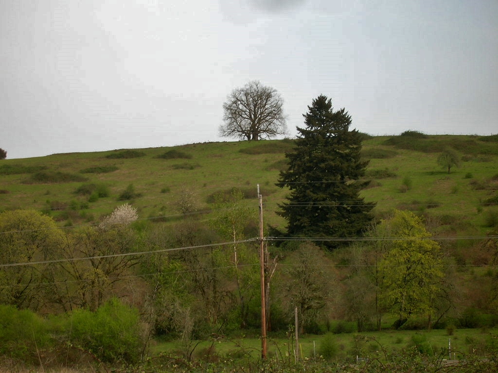
On a hill just south of Hillcrest, there's a great old tree. Most everything has been cleared around it, so it stands out against the sky.

I don't think that's an Oak, but it's a presence on the top of the hill;
pasture at bottom by utility poles would be park
One of the park acquisitions on Council agenda Monday night showed a development that hasn't shown much of itself yet. According to the Staff Report it's had a formal "Urban Growth Decision," which imposed a condition of a park dedication, but that might have been a while ago, and I don't remember seeing any other Hearing Notices more recently (do you?).*

There are no great conclusions to draw here, I don't think. The area is a zone of some of the biggest greenfield developments in town, a large bloc of parcels in transition. Between the projects at 27th and Kuebler by the I-5 interchange, the Fairview projects, and any Hillcrest project, there's a lot of potential here. Even with some of the plans for Fairview very forward-looking, the overall development pattern may still look backwards too much to existing 20th century autoism, however. It's worth keeping an eye on. It is interesting, if nothing else.

It's also, at least until it's developed, a little picturesque! It's too bad the park won't be at the top of the hill instead of the bottom. (Just off the top of my head, I can think of many more parks in low lands along creeks than on properties with a view. It's easier to monetize the latter, so it's not surprising developers sell off the swampy parcels for public use.)

Just south of Hillcrest, park area in light blue
(I think the relative scale on the inset is still a little big!)
The park property is to the south of Hillcrest, across the street from one of the Fairview projects, and downhill from existing development and along the creek that parallels Reed Road.

Reed Road here is signed for 45mph, and Battle Creek is also very zoomy. The corner of Reed Road and Battle Creek lacks crosswalks and sidewalks. While sidewalks on Reed Road have generally been part of conditions for development and will be constructed by developers (eventually), I'm not sure that crosswalks have ever been included, and the City will need to plan for these - as well as for lower speeds, hopefully. The streets are "minor arterials," but they will be increasingly residential.

Wednesday, April 11, 2018

Work on 12th Street Between Hoyt and Fairview to Start

12th Street at the Clark Creek Bridge and Culvert
Between Hoyt and McGilchrist the sidewalk disappears
From the City:
On Wednesday, April 11, 2018, utility relocation work began on southbound 12th Street SE from Hoyt Street SE to Fairview Avenue SE as part of the 12th Street SE Southbound Widening Project. This is the first phase of a project that will widen the current roadway to accommodate a southbound right turn lane to Fairview Drive SE. Franchise utility relocation work will continue through May 2018, and will require traffic shifting and lane closures on 12th Street SE. Pedestrians and motorists are asked to use caution and plan for some delays.

Additional improvements include replacing an existing culvert under 12th Street SE at Clark Creek, storm drain modifications, sidewalk improvements, and traffic signal modifications on the northwest corner of the intersection of Fairview Avenue and 12th Street. The additional improvements are anticipated to be completed by December, 2018.

This project was identified in the City Capital Improvement Plan, and is designed to help relieve southbound traffic congestion, provide sidewalk and bike lane improvements, increase street illumination, and enhance fish passage on Clark Creek. The project is funded through a combination of Federal Surface Transportation Program funds, City of Salem Transportation and Stormwater System Development Charges, and Stormwater Utility Charges.
Project map (2016)

Tuesday, April 10, 2018

Reaction to Winter-Maple Bikeway Revealing in Language

Not long after Council adjourned last night, the paper published a relatively lengthy piece on action for the Winter-Maple Family-Friendly Bikeway - or maybe now, the Winter-Maple Bicycle and Pedestrian Plan.

One of the interesting things to come out of it is the role just of language.

(update - April 11th)
From the paper's early story:
The Salem City Council on Monday approved a plan to construct a bike and pedestrian path connecting the Capitol Mall and Salem Parkway areas.

The decision followed a debate over whether to include last-minute additions proponents expect will slow traffic near the Oregon School for the Deaf.

The bike and pedestrian path, called Winter-Maple Neighborhood Greenway, doesn't appear to have a confirmed completion date, but Monday's decision paves the way for city officials to start early work on the project.
The route certainly is a "path" in the sense of a "way" or "route." But it is not primarily a path in the sense of a paved path off or out of the street right-of-way, which has seemed like it was the ordinary sense of "bike path." We have bike paths in parks, but not on our street network.

It's hard to say whether this use of "path" is a misunderstanding of the nature of the plan and the nature of low-traffic bikeways, which would be understandable since the piece was published last night, or whether it represents autoist bias and a back-handed denial of bike traffic in the street itself.

Monday, April 9, 2018

At the MPO: New Round of Bonus Funds

About $3/4 million in additional Federal funding
The Technical Advisory Committee for our local Metropolitan Planning Organization (SKATS) meets Tuesday the 10th, and they're still talking a lot about the performance measures created by the latest Federal transportation bill. It's a lot of inside baseball and it has seemed like the more important thing was the spirit with which agencies approached them rather than the letter and detail of the measures and rules. Weak performance measures could be implemented assertively, and strong measures might be ignored or satisfied weakly and barely. Interpretive vigor has always seemed more important than letter of the law. Maybe this is wrong, but when "decrease reliance on the SOV" is a high-level policy goal for Salem (I'm switching a little in the example, from the MPO to City of Salem), that is all the direction that should be necessary. Instead, we have all kinds of half-hearted dodges that are meant to satisfy a very weak notion of "decreasing reliance on the SOV" instead of a strong interpretation and strong actions. So the politics of interpretation rather than the technical details of rule-writing have seemed to matter most.

Maybe when the latest round reaches the Policy Committee there will be more to say.

The most interesting thing on the TAC's agenda is an announcement of what looks to be about $3/4 million in unexpected, new funding.

It should be used to "decrease reliance on the SOV"! It should not be used on a capacity increase for drive alone trips. It should be used on capacity increase or safety improvement for walking, biking, or busing.

Meanwhile, and not on the agenda at all, the MPO has had a survey out on the high-level policy goals for the new 2019 Regional Transportation System Plan they are starting to write.

A simple, proposed addition to goal 7 in the RTSP
Our local 350.org chapter proposes some language to add to goal 7. Under this it is easy to nest things like Safe Routes to School, transportation demand management, walk/bike/bus things generally. If people were going to concentrate comment on one single issue, greenhouse gas emissions is an excellent candidate. No other advocacy has emerged around specific other revisions, and so it seems worthwhile to focus and unify on this. If you haven't already, tell SKATS to add "and to reduce greenhouse gas emissions" to goal 7 in the RTSP. The survey goes through April 16th.

Look for the historic sign
next to the entry
You can download the agenda and meeting packet here.

SKATS Technical Advisory Committee meets Tuesday the 10th, at 1:30pm. SKATS is at 100 High St. SE, Suite 200, above Andaluz Kitchen and Table Five 08.

Sunday, April 8, 2018

The Hype on Robot Cars Deserves Great Skepticism

In the very same paper with a story about another car attack, this one in Germany, there's two pieces about robot cars. They use the same stock imagery and look like a coordinated PR effort by robot car interests.

But, you know, just wait until robot cars can be hijacked remotely and turned into lethal drones.

In the national news section

Saturday, April 7, 2018

City Council, April 9th - part 2

From here of course Monday's Council meeting is dominated by the Winter-Maple Bikeway. But there are several other things to note in passing, and some totally deserve more comment and analysis. There's a lot of meat on this agenda.

Zoning proposal for close-in West Salem
One project, an important project, is the West Salem Code Clean-up for the close-in Edgewater area. I don't feel like it has got quite enough attention. Council looks to set a date for a Public Hearing on it later this month. (And there may be more to say then.)

Some good news? At least theoretically, a full build-out with the new zoning would decrease car trips!
DKS Consultants prepared a memorandum for the City of Salem, dated February 14, 2018, analyzing the traffic impacts of the proposed zone changes....The results for trip generation analysis indicate a decrease of approximately 4,155 daily trips for all three areas under the reasonable worst-case development under the proposed zoning compared to existing zoning. Furthermore, each area has a decrease of daily trips individually: 154 daily trips for the West Salem Central Business District, 3,017 daily trips for the Edgewater/Second Street Mixed-Use Corridor and 984 daily trips for the Second Street Craft Industrial Corridor under the proposed zoning compared to existing zoning.
The memo's not included in the full packet, so maybe this is a little obscure. But, hey, if the traffic modeling projects a decrease, that's good news.

Do we really have zoning that will fill in these gaps?
So much car storage and empty space!
It looks like the plan rationalizes off-street parking a little, but it does not remove minimums and fully let the market determine the amount. That's a disappointment, but the plan would offer incremental improvement. (Ordinary standards for multi-family housing are 1.5 stalls per unit, but in a couple of places, including here, the City uses 1.0 stall per unit, so that's a 33% reduction from the usual, I guess you could say.)

Thursday, April 5, 2018

City Council, April 9th - Winter-Maple Bikeway

Council meets on Monday and there's a surprising number of things that might be worth a comment. Chief among them is formal adoption of the Winter-Maple Family Friendly Bikeway Plan. (I'm splitting this into two posts, and I'll update a link here later for part 2.)

Coffee Shack, Drive-thru, 10 foot path
Intersection of Cherry and Auto Group Avenues
And if you wanted a nearly perfect metaphor for its execution, the plan for a coffee shack and drive-thru at one of its important intersection treatments shows a certain incoherence in land use and lack of urgency about its completion.

Tuesday, April 3, 2018

New Paint for the Dome Building? A Crosswalk on Division? - Walking Bits

Did you get out for a walk on Saturday last weekend? The weather was good, and in the afternoon the sun came out and it became great. The Cherries at the Capitol and elsewhere around the city were in full bloom and just beginning to drop petals. Here's one slide show from midday, before the sun was fully out.

Elsewhere there were other things to note also.

It looks like the Dome Building is getting a paint job to match the Kirkbride Building.

A new paint scheme for the Dome Building?
Would match the Kirkbride!

Dome Building in winter 2013, South facade

The main Kirkbride Building in 2012
That color scheme on the Dome Building would really unify the two buildings across Center Street. I look forward to the finished state.

Monday, April 2, 2018

State Street Study at Planning Commission Tuesday

The zoning and street concepts generated by the State Street Study are going before the Planning Commission tomorrow, Tuesday the 3rd at 5:30pm, and the boo-birds are out. It will be interesting to see just how much criticism the Plan attracts and how forceful it will be. (Agenda and Staff Report)

If State Street were fully built up, some winter shadows
might fall on the south side of Court Street
Earlier, an architect recently moved into the Court-Chemeketa Historic District submitted comment to City Council. They offered several very detailed criticisms of the plan and the process, and generally seemed to want to delay it, hoping perhaps to invoke a higher level of federalized process. In particular, they want lower building heights on State Street:
Shadows on properties where the owner wishes to harness solar power to save monies on utilities could have a significant financial impact on the ability to save monies and/or make the decision to make a capital investment for solar equipment. Although there is no right to light statutory framework within Oregon, it seems that before something is going to reduce a property owner's ability to conserve electricity, an analysis should be made. Under the current zoning, such information could be weighed in by the Planning Commission in deciding whether or not to approve a proposed project and/or propose mitigation measure, but under the proposed zoning, an administrative approval could be issued and then the property owner would have secured rights to eclipse a neighbor's property risking disputes and potential claims and litigation....

Since the proposed zoning changes will permit, by right, 55 foot tall buildings and potentially cast significant shadows into the National Register District located north of the State Street Corridor, causing a change in the character of the District's use or setting and introducing incompatible visual, atmospheric, or audible elements; we request that a Section 106 review be conducted. We further request that the City of Salem Historic Landmarks Commission be designated as the consulting party for the City of Salem and that neighbors directly affected or the North East Neighborhood Association (NEN) also be designated a consulting party.
This is interesting because an important element in opposition to the Salem River Crossing has been stalling afforded by the requirements of process. So you might say "what is sauce for the goose is sauce for the gander." But here the process is still unfolding, and the stalling on the SRC was necessary only because the process was so profoundly flawed. It was a tactic of last resort. Since the process is still unfolding here, and since the proposed changes are nowhere near as monumental as the SRC, this seems like a disproportionate response.