Wednesday, June 29, 2016

Salem Teen Killed in Hit and Run While Walking near Liberty and Lincoln SE

Liberty at Lincoln SE - three rather zoomy auto lanes,
one bike lane, an unmarked crosswalk only
This morning there are reports a person on foot 18-year old Alex C Armes was struck and killed in the 1600 block of Liberty St. SE.

This would be the third Salemite killed on foot this year.

Previously:
Update 1, late afternoon

From the Salem Police:
Salem Police are currently investigating a fatal hit and run incident involving a pedestrian.

Officers were called to the 1600 block of Liberty St SE near the intersection of Lincoln St SE at approximately 3:15 this morning on a report of a subject laying in the street. Officers arrived to find a deceased subject who had been struck by an unknown vehicle. The Traffic Control Unit was dispatched to investigate the scene and process for evidence and the roadway was closed until approximately 8:30 am.

The name of the victim is being withheld at this time pending notification of next of kin.
Update 2, Thursday midday

From the PD:
The victim in this case has been identified as 18-year old Alex C Armes of Salem. His next of kin has been notified.
This post will be updated.

Winter, Chemeketa Street Bikeways Blocked by Olympic Trials Wednesday, Thursday

Race walking is no different really than any other kind of racing. If you think too hard about it, just about any race is kindof silly. But we do love to race and it seems to answer some deep human drive.

If you watch the races, stop in at Hallie Ford
Royal Nebeker, "Blue Bike," 2013 (detail)
Hallie Ford Museum of Art
Even so, walking is fundamentally a slow, often leisurely, activity, and making it into a form of racing seems especially silly, a contradiction. (There's even a "silly walk," for it, after all!)

So it's still a little odd to see that we are hosting the deeply serious Olympic Trials for Race Walking.

And that means some street closures on Wednesday and Thursday.

From the City release:

Tuesday, June 28, 2016

At the MPO: A Public Hearing on I-5 Widening, Light on Deliberation

Today, Tuesday the 28th, the Policy Committee for our local Metropolitan Planning Organization will hold a Public Hearing on the proposed amendments for I-5 widening to be added to the 2015-2020 funding cycle and the 20 year Regional Transportation System Plan. (Meeting packet here, see previous discussion here.)

Location for proposed I-5 widening
A Digression on Public Process

The Hearing itself doesn't seem all that important.

On the matter of the Police Station as well as on Rob Handy v. Lane County (RG article here, Court calendar entry here) at the Oregon Supreme Court, there has been some local discussion of Process.

Maybe we'll circle back to those matters as they relate to the City of Salem, but they seem at least peripherally relevant to SKATS.

The formal Public Comment period for the amendments closed on June 14th - but here we are a couple of weeks later for a Public Hearing. The Staff Report agenda item recommends that the Committee
I. Conduct a public hearing for the amendments to the SKATS 2015-2035 RTSP, FY 2015-2020 TIP, and associated AQCDs.
2. Adopt Resolution 16-6 to amend AQCD for the SKATS 2015-2035 RTSP, Resolution 16-7 to amend SKATS 2015-2035 RTSP, Resolution 16-8 to amend AQCD for the SKATS FY 2015-2020 TIP, and Resolution 16-9 to amend SKATS FY 2015-2020 TIP. A unanimous vote is required.
Especially with the requirement for a unanimous vote, it looks like Committee members are on notice that this is a done deal. There is no actual deliberation and consideration that will be going on in the Public Hearing. The decision is already made, and the Hearing a pro-forma gesture to satisfy the need to "deliberate" in public.

Sunday, June 26, 2016

City Council, June 27th - First Phase of Portland Road Funding

Council meets on Monday, and they will lead with the Police Station and formal adoption of the annual Budget. There's nothing more to say on the Police Station here, though, and the real budget action happened at the last meeting.

So as the Urban Renewal Agency, City action on funding projects on Portland Road is probably the most interesting thing.

Portland Road

The Urban Renewal Agency has several items related to the Portland Road Study. After formally adopting the amendments to the North Gateway Urban Renewal Plan (see previous discussion here), they will allocate an initial tranche of $1,730,000 for four projects:
  • $700,000 for grant programs (additional amendments on these here)
  • $80,000 for a feasibility study of the Public Market, Food Hub and Incubator (the Mercado concept)
  • $500,000 to support development of Industrial Flex Space, Housing and Mixed Use
  • $450,000 to design Portland Road Streetscape Improvements north of Bill Frey Drive (phase 1)
The Bucket List

There is an update on the approach and priorities for the "code clean-up" project. Unsurprisingly housing will lead, and it is also interesting to see how the State Street Corridor project will be used as a template for simplifying the overlay zones. Hopefully the general needs for a template will not dilute any useful specificity for State Street.

Thursday, June 23, 2016

Downtown Advisory Board to get Update on Opportunity Sites

Greenbaum's (right) in the intact Eldridge Block, 1954
University of Oregon
The Downtown Advisory Board is meeting today, Thursday the 23rd, and they are getting an update on the potential "opportunity sites" downtown that might be purchased with Urban Renewal Funding in an effort to kickstart redevelopment on vacant or underutilized lots.

Project concept for State and Commercial
via Nathan Good Architects
In that update is a review of property owners who would and would not be interested in selling or otherwise participating in the "opportunity site" deal.

Contribute a Route to v2.0 of Wander Walks Map!

And here's yet more pleasant map news this week. This time it's for travel on foot.

Wander Walks Salem Map 1.0
Cherriots and the WVP Health Authority are collaborating on Wander Walks 2.0, a new edition of the walking map for the Salem area.

The first version, 1.0 we'll call it, at least from here seemed to have too many routes that used busy streets and thus it did not seem optimized for the experience of walking itself. It was also centered on downtown and not necessarily on interesting routes that might be near residential neighborhoods, nearer where you live and might want to walk. There was an implied autoism, then, with these as destination walks to which you drive. One reason for the focus might have been that it was authored by a group of international MBA students. While they brought fresh eyes to Salem and to the project, they also may not have had enough local knowledge about walking here. There's always trade-offs. Crucially, their participation and the institutional support behind it meant the project did actually get completed.

So with the most difficult work of a first edition completed, projects like this are easy to iterate with follow-on editions. Now that the print run is gone, it's time for a revision.

From Just Walk:
In partnership with WVP Health Authority and Cherriots - Salem Keizer Transit, we’re recruiting volunteers to design unique walking routes through several parts of the city. These “Wander Walks” will be printed on colorful new neighborhood maps later this year and distributed throughout the region.

This is your chance to be creative while helping people get to know their local area better and connect to resources like playgrounds, parks, community gardens, and Little Free Libraries.

There’s no long-term commitment, and you can choose the length of your walk—all abilities are welcome. You can map your route alone or with a friend. There are no high-tech skills required: we’ll show you everything you need to do. All you bring is a willingness to head out and scout the neighborhood!

To sign up to volunteer, please email Jeanine Stice with WVP Health Authority at jstice@mvipa.org.
This will be a great way to tap into that local knowledge base.

Wednesday, June 22, 2016

Revised Salem-Keizer Bike Map Just Released

Here's some welcome summer news!

Our local Council of Governments has released the May 2016 update of the Salem Keizer Bike Map. In addition to paper maps that will be available at Cherriots, local bike shops, and Travel Salem, there's a new online/mobile version.

Check it out!

The paper copies will be delivered gradually, so you might wait a few days before starting on that quest. But online it's available right now.

Tuesday, June 21, 2016

Quasi-Town Squares in the News, Neighborhood Association Bits

A couple of downtown public spaces were in the news over the weekend, and it might be interesting to consider a moment how they functioned, especially as they remain more autoist than not.

Methodist vigil for Orlando Victims
(via Statesman Journal)
Refugee Resettlement Welcome (via Statesman Journal)
It was a surprise to see the Sculpture Garden at the Conference Center used for the end of a short march through downtown and then a vigil. Peace Plaza would have seemed like a more natural place, but the participants seemed to be mostly from out of town, those participating in an Oregon-Idaho Methodist conference that was already going on at the Conference Center. So it was a straight-forward move to use the patio annex we know as the Sculpture Garden in the way a group might use a town square since they wouldn't necessarily know about Peace Plaza and it would be, relatively speaking, distant from the Conference Center.

Sunday, June 19, 2016

Kick Off Summer Right: Make Music Salem and Bike Boulevard Field Trip

Forget Druids and Standing Stones! Could there be a better way to celebrate the summer solstice than with citywide music festival?

Playing on the Union St. Bridge, 2012
Salem has a worthy successor to the the street pianos from a few years back.

Make Music Salem joins
a worldwide phenomenon on the summer solstice. The city’s streets, alleys, sidewalks, parking lots and public spaces will resound with the joyful noise of Make Music Day on Tuesday, June 21.

From Peace Plaza at Salem Public Library to Salem Cinema and from the Oregon State Capitol to the Boys & Girls Club of West Salem, roughly 30 venues will host music events. Performances begin around 10:30 a.m. Over the lunch hour and into the night, more musicians will join the fun.

More than 100 bands and singers of all ages and abilities will perform big band, folk, hard rock, soul, hip-hop, country and music of all styles. Mark Green, co-organizer of Salem’s event, said, “There will be something for everyone.”

The best thing: It’s all free.

“Three principals of Make Music Day: It needs to be free; nobody can be charged. Nobody can get paid. Music must be outside, unless it rains,” Green said. “That’s what’s beautiful about it.
You could structure a performance schedule for yourself, of course, but it might be best just to wander on foot or on bike. Discover something new, yield to serendipity. Just wander.

All over downtown!

Friday, June 17, 2016

Greenbaum's Closing, Historic Building Still for Sale

Well this is a serious bummer. Greenbaum's is closing and the building is for sale.

Back in 2014 it went up for sale
You might remember when it went up for sale about two years ago. Apparently they didn't find a buyer. From the paper:
[A]fter two years trying to find the right person to take over the business, owners Sylvia and Bill Dorney announced Thursday they are closing the store. A series of sales to empty inventory will start next week and the business will be gone by the end of August.
A version of the business seems to have been in continuous operation since November of 1899. Here's an early ad that Isadore Greenbaum ran in the paper. During the late fall of 1899 and most of 1900 (perhaps longer) he operated a "close-out" business. (So in a way, it ends exactly as it began.)

Early ad, March 6th, 1900
The business evolved through the generations. From Greenbaum's Quilted Forest:
Greenbaum’s Quilted Forest is a third generation family business that has evolved over time. It started as a dry good’s store, Greenbaum’s Dept. Store, in 1900; became a fabric store; Greenbaum’s Fine Fabrics, in 1946; and finally a quilt shop, Greenbaum’s Quilted Forest, in 1988. The shop is in a beautiful historic structure that was built in 1889, and is located in the heart of the downtown historic district in Salem, Oregon.
As important the quilt shop is, the building is even more important.

Thursday, June 16, 2016

Cook to Attend Safe Routes to School Conference Later this Month

Here's some good news for transportation in Salem. Councilor-to-be Sally Cook has said that she will be attending the Oregon Safe Routes to School Conference in Eugene later this month.

Highlights of the conference include:
Opening keynote: Race, Class & Equity in: Where to Begin - with the National Partnership's very own Keith Benjamin leading the conversation.

A free evening talk with Lenore Skenazy, author of Free Range Kids. "Giving Our Children Freedom & Independence".

Sessions on youth-led campaigns, walk-audits, how to integrate health partners in Safe Routes to School, adaptive bicycling, ways to institutionalize Safe Routes to School through>policy, and more.
There's huge untapped potential here in Salem.

In May's "Bike and walk Challenge," only three Salem-area schools participated:
  • Washington Elementary
  • JGEMS
  • Harritt Elementary
Three schools only participated also in 2010
In recent years, events in May and October have seemed to average around 3 or 4 schools participating.

Wednesday, June 15, 2016

Hit and Run, Probable Speeding on Boone Road Highlights Gap at Commercial

Boone Road is an older road that in most ways was replaced and even orphaned by Kuebler. While parts of it have been rebuilt, it has gaps and its whole length has not yet been retrofitted with sidewalks and bike lanes. Even so, many times it is calmer and more pleasant for east-west travel than Kuebler, notwithstanding the sidewalk and bike lane "improvements" bolted on to the quasi-highway.

But not always.

From the paper:
Marie Preble, 55, and a friend were walking on a residential portion of Boone Road SE toward Commercial Street SE on May 29. It was Sunday evening, and the sun was still shining. The stretch of Boone Road didn't have a sidewalk, so most pedestrians, like Preble and her friend, walk on the road's shoulder.

Around 5:30 p.m., a car drove along the road, going what seemed like well over the residential speed limit, witnesses said. The car struck Preble, knocking her to the ground. While her friend rushed to Preble's aid, the car sped away....

[The friend] said they are also looking for witnesses who may have seen the driver or the car westbound on Boone Road near Commercial Street at 5:30 p.m. on May 29. The car is described as being a white or cream large sedan. No license plate or driver description is available.
The article doesn't specify whether the crash occurred west or east of Commercial. Both sections of Boone Road have sections very close to Commercial that lack sidewalks and seem to correspond generally with the description of the crash site.

Boone Road west of Commercial, looking west

Boone Road east of Commercial, looking west
It is very interesting that this section of Boone Road is not identified as a very urgent need for retrofits.

Tuesday, June 14, 2016

City to Improve Crossing at Mission and Winter; Progress on Bike Counter Installation

Two very close-in projects this summer look to help biking in Salem, one for Engineering and one for Evaluation.

At SCAN's May meeting or in the annual newsletter, you might have heard about an interesting part of the Mission Street repaving project scheduled for this summer.

The intersection of Mission and Winter has been a problem for a long time. Winter Street is a key bikeway running north-south, and Mission Street a busy road making for a difficult crossing and significant barrier.

On Winter looking south from the bike lane at Mission, 2009
For those on foot, the way on the south side winds with a couple of sharp elbow angles, but it is not difficult to negotiate the 90-degree turns. On bike the tight right-angles and misaligned ramps and bike lanes are a real pain. (Perhaps also for those in wheelchairs.) For both those on foot and on bike the tight quarters also crowd people when they are together waiting to cross north and when there is a weave necessary for those going south.

Sunday, June 12, 2016

St. Edwards in Keizer Stresses Light and Sidewalk

Has anyone visited or worshiped at St. Edwards since the new church opened a year or two ago in Keizer off River Road at Claggett?

Memorial Coliseum has been in the news lately, and it occurs to me that the form of St. Edwards as I have seen it in photos is at least a little like the Coliseum.

St. Edward interior - via De Loreto Architecture
(Looking from altar back to narthex)
It's got the big wood arches of an older gabled nave structure. (Look at all that wood!)

But superimposed upon that is a modernist box with huge clerestory windows.

Exterior with moon rising - via De Loreto Architecture
Compare to the Coliseum.

Saturday, June 11, 2016

MPO Subcommittee Moots Sidewalks vs. Third Bridge for 2018-2023 Cycle

The technical advisory committee for our local metropolitan planning organization meets next week and they've got a bunch of substantive administrative matters on tap. Significantly, as they look to the 2018-2023 cycle and plan, they are beginning to talk about setting aside funding for parts of a Third Bridge, and this merits close attention. (Agenda and packet here.)

General Discussion on Priorities and Values

There's a good bit of discussion about evaluation criteria, and the policies and values that might inform them. Funding parts of a Third Bridge is being considered. Because of the dollar value, it potentially dominates everything.

This casts a long shadow over everything
September 2014 Oversight Team Presentation
The whole section in the Staff Report is worth quoting:
With over $14 million in federal funds to program, there are several policy questions that should be discussed prior to selecting projects for the draft SKATS FY 2018-2023 TIP....

2. Should an amount be set aside to partially fund a large and expensive regional project?

The SKATS RTSP contains a number of large and expensive projects that are difficult to program relative to the limited funds received by SKATS. There are six projects between $5-10 million, and five over $10 million. These include a new interchange at OR22 at Cordon Rd., upgrading McGilchrist St., widening Cordon Rd., and several other projects. The FHWA record of decision (ROD) for the Salem River Crossing Final EIS is expected to be completed in 2017, and there has been discussion about setting aside some of SKATS's federal funds for an initial phase of the project.

Large projects such as these require a substantial amount of funding and many years to complete. With $14 million available over the next five years, now might be the time to set aside some of those funds to go toward a large project. Another option is to also set-aside an amount in the illustrative years of the plan (FY 2022 and 2023), when another $5 million could be available (although those years are beyond the current federal act (FAST Act)). Either approach might also be a strategy for leveraging future competitive state and federal funds such as a federal TIGER grant.

The implications, risks, and challenges of doing a large set-aside include:
a. It leaves fewer funds for Complete Street projects, ITS, transit projects, intersection improvements, etc.
b. If a project is only partly funded using SKATS funds with the intention to leverage a state/federal grant, there is the risk of not getting a grant and therefore having the SKATS funds either sit idle or not be used efficiently.
c. Competitive federal and state grants are more often provided to projects that have significant local match.
d. It should be kept in mind that federally mandated performance measures in the near future will require projects in the SKATS TIP go toward meeting targets for safety and system performance as noted on page 2.
e. For a project associated with the River Crossing, one concern would be identifying what the initial project would be and which jurisdiction(s) would provide the match. In order to include a project in the adopted TIP, it must have a description of the project and a source of match. (Note: funds that SKATS identifies for the 2022 and 2023 illustrative years would not be added to the FY 2018-2021 Statewide TIP, so don't require as much detail.)

Staff recommendation - A discussion is needed by the Policy Committee and TAC about this option.
I don't know what is the best frame for advocacy on this.

Thursday, June 9, 2016

A Slightly Cranky Note about Romancing the Penny Farthing

Did you see the story about the Centennial celebration for the Historic Columbia River Highway?

NY Times, 1924 (via columbiariverhighway)
The highway is a key milestone between the establishment of the State Highway Commission in 1913 and the establishment of the nation's first gas tax in 1919.

Besides being picturesque, it's important transportation and tourism history, and it is so very nice that it is being restored for lots of walking and biking pleasure.

So how important is it that we remember history accurately and don't also enhance it with the soft-focus glow of more general nostalgia?

Yeah, it's not that important. It's a little pedantic to insist on the details.

At the same time, to the extent today that tropes, stereotypes, and myths like the "scofflaw" or "lawless cyclist" or "bikes don't pay their way" infect modern debates on transportation, similarly older tropes color the way we talk about bicycling and transportation. In many ways we talk about bikes as symbols and as lifestyle emblems, as instances of signalling or of projection, and not about bikes as neutral technology that is used in particular ways at particular times. If we want a contemporary debate that is straight-forward and factual, our readings of history should strive for a better factual underpinning as well.

At the centennial and ODOT staffer showed up with a replica of an 1893 bike model. That was pretty cool to see. Another person showed up with a penny farthing. That got lots of attention.
"Sam Hill" - 100th birthday of
Historic Columbia River Highway
via BikePortland
Here is railroad baron and highway advocate Sam Hill (his mansion is now the Maryhill Museum) with the penny farthing.

But in 1916 a penny farthing had been already old-fashioned for a quarter century. That's a pretty anachronistic image then.

In computer terms, that's like a Macintosh computer from the 1980s!

Tuesday, June 7, 2016

ODOT Shares Summer Chip Seal Schedule; Big Change at BTA

If you bike, you'll know the scourge of chip seal, a coarse but inexpensive substitute for smoother asphalt.

Coarse Chip Seal (left) and Smoothed down Asphalt (right)
via Davis Vanguard
In a car it doesn't make much difference in the feel of the road, but on bike it's a vibratory wrist- and saddle-ache. The wheels of passing cars will sometimes throw a loose "chip." Sometimes, too, the discontinuity on the seam (like in the picture) can contribute to an unwanted wobble in steering.

It's bad news generally for bicycling.

This year, ODOT helpfully sent out a paving schedule for chip seal treatments.


Here are the highway names and milepost numbers for local paving this summer:

Monday, June 6, 2016

Developments at the Planning Commission Show Misaligned Mobility and Land Use Goals

In the context of discussion on "granny flats," or "accessory dwelling units," a resident of  one of our gridded, close-in neighborhoods said at their last neighborhood meeting:
[I don't] want NEN to absorb more parking and driving problems. Many of the streets are so narrow...with parking on both sides. Large vehicles have a hard time driving through the neighborhood....The city center is compacted [and I am] concerned about the loss of green space.
In this light, a couple of Public Hearing announcements are of minor interest. Both of them involve the relation between density and mobility. One of them is a traditional, car-oriented apartment block complex, the other is a Planned Unit Development more experimental in nature.

The two projects show some of the costs of pushing development out away from the city center out towards the edges of the urban growth boundary and the ways that our high-level goal in the Comprehensive Plan to "decrease reliance on the SOV as the dominant means of travel" is misaligned with our practices in the way we actually conduct development.

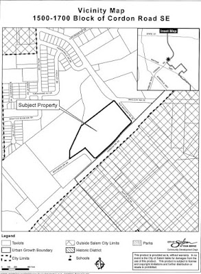
1500 Block of Cordon Road SE

On Tuesday the 7th at the Planning Commission there will be a
Class 3 Design Review, Conditional Use Permit, Class 3 Site Plan Review, and Class 2 Driveway Approach Permit to allow development of an 82-unit apartment complex...located in the 1500-1700 Block of Cordon Road SE....
I believe this is for a second phase of a project, and you may remember some sidewalk requirements that had been debated during approvals for an earlier phase.

Car-dependent, little transit
Just in general terms, this is an utterly car-dependent site, located right on the edge of the Urban Growth Boundary, directly abutting Cordon Road, and remote from anything useful.

If we want to reduce drive-alone trips, development here fails to meet that policy goal.

Saturday, June 4, 2016

City Council, June 6th - The new Website

By adding clicks and layers to the steps citizens have to take to review Council agenda, the new Council website in some ways hinders public access.

The new system's pain in the butt! It may offer a mechanism to publish staff reports and other items in a more timely way, but it also requires additional steps and makes scanning and screening (in the sense of the light reading of documents to determine whether they merit more detailed reading) agenda items more difficult.

It may, in fact, actually make it easier to bury controversial items in hopes they will be overlooked.

The regular overview here will evolve some, and depending on how closely you read, you may find some tinkering and awkwardness.

Here is the Council agenda proper, the Urban Renewal Agency agenda, and the Housing Authority agenda. The old wall-of-text was hard to read, but it was convenient to have all three on one page. This approach looks better logically and seems more organized, but it is less convenient for citizens who want a synoptic overview.

One new feature seems to be that the new format for Staff Reports has already been changed. At first I thought the Reports had disappeared!

But it turns out they may no longer be published as a pdf and instead are some form of html text.


You have to click on the "text" subtab to find the Staff Report in html rather than a pdf. Hopefully that will make searching easier! But hiding behind the tab labeled "text" is not very helpful - that's a little "secret handshake" in spirit.

12th Street at the Clark Creek Bridge and Culvert
Between Hoyt and McGilchrist the sidewalk disappears
the new construction is on the left, just past the bridge railings
This item is for the widening of 12th Street SE between Hoyt and Fairview. You may recall that a sidewalk project was bolted onto a new turn lane project. The north half will add sidewalks and a new culvert for Clark Creek to a part of 12th Street that lacked sidewalks. This will be a real help! But there's also a new turn lane being added, and this will likely increase speeds on 12th.

Anyway, the matter at Council is an intergovernmental agreement with ODOT that formally authorizes the City to acquire new right-of-way, which because of the Federal funding for the project was something ODOT only was apparently authorized to do. (Seems like this is an instance of annoying red tape!)

Oil Trains, Bike More Challenge Afterparty - Newsbits

You've seen the sideways soda cans painted matte black. We may not get the giant oil trains, but oil comes through Salem.

And crucially, ODOT and the railroad companies try to keep as many details secret as possible. So who knows what really is being shipped.

Oil train derailment and fire near Mosier - KVAL
From KVAL yesterday
A train towing cars full of oil derailed Friday in Oregon's scenic Columbia River Gorge, sparking a fire that sent a plume of black smoke high into the sky.

The accident happened around noon near the town of Mosier, about 70 miles east of Portland. It involved eight cars filled with oil, and one was burning, said Ken Armstrong, state Forestry Department spokesman. [Sure looks like more than one on fire.]
I suppose it's alarmist to say "It could happen here." But it could. The UP railroad passes right by two schools, in fact. (And there are other hazardous things on those railcars, too, it should be said.)

Thursday, June 2, 2016

Abbotsford BC Plan Shows How it Can Be Done

This is apropos of nothing really, but it's something to come back to. We have our TSP here, which we updated a few years back with Bike and Walk Salem, the State just released a new Bicycle and Pedestrian Plan, and none of them come close to a statement or vision like this:

Abbotsford, BC draft Official Community Plan
(See Chapt 3 for more on this policy)
"Make Walking, Biking & Transit Delightful."
  • Align land use and transportation
  • Redesign streets
  • Transportation choice
  • Rethink parking
Yeah. That's what we're talking about for high-level policy. As a policy statement it's spritely and clear. As a set of goals it's actionable.

Oregon: final draft adopted May 2016
Compare that energy and concision to the rhetoric in the new State Bicycle and Pedestrian Plan:
THE VISION
Specifically by 2040, the Plan envisions that:
“In Oregon, people of all ages, incomes, and abilities can access destinations in urban and rural areas on comfortable, safe, well-connected biking and walking routes. People can enjoy Oregon’s scenic beauty by walking and biking on a transportation system that respects the needs of its users and their sense of safety. Bicycle and pedestrian networks are recognized as integral, interconnected elements of the Oregon transportation system that contribute to our diverse and vibrant communities and the health and quality of life enjoyed by Oregonians.”
They're different, I know. One's a state-level plan, the other's for a municipality about the size of Salem and is not solely a transportation plan.

But it's all about the desire, the verve, and the vision.

See. It can be done.

Those wacky Canadians.

(They look to be formally adopting the plan, which seems to be much like our Comprehensive Plan, later this month. Maybe after reading more of it there will be more to say. As a comparison, it could be very interesting.)

Wednesday, June 1, 2016

For Tonight's Work Session, Thoughts on Parking

Council meets tonight, June 1st, for a work session on the Police Station, and the City continues to do a lousy job of proving its case!

MOAR PARKING!!!
Too Often the City Asserts, but does not Prove

Former City Councilor and chair of the Blue Ribbon Committee, TJ Sullivan, said on Facebook:
The State Police Facility is a different animal and the cost per square foot is also less than police departments that have been built in other cities across Oregon. It has nothing to do with local architects or contractors, or the fact that it is a design build, or value engineered. It has to do with how the needs of city police department differ from the State Police and how that impacts the final cost.

Chief Moore is a very reasonable person and I have never known him to want anything that is extravagant. As I have talked through the new facility with him it is clear that his understanding of what the Salem Police Department needs now, and what they will need in the future is the best insight that we have. I would encourage you to trust his judgement as well...

My original point is that people knew that the State Police Facility differs in need and therefore design from the City's Police Facility and yet it was offered that the State Police Facility was built for a lot less and therefore the City's Facility could also be built for a lot less. What was inconveniently left out is that State Police Facility wouldn't meet the needs of the City. [italics added]
If the needs of a city police force are so different from those of the State Police, it should be easy to enumerate and prove these in a few paragraphs, or perhaps a short memo.  But over and over the City cannot seem to do this, or refuses to do this.

What is "left out" is proof that Salem cannot meet its need in less expensive ways. Over and over this is asserted, but over and over it has never been argued in a serious way, at least in public.

This is a consistent pattern with the City.