These will be meandering notes, more about the way history threads through the three, and the ways we don't always do a good job honoring that history.
 |
| Capt. Chas. Bennett, died 1855, in the IOOF Pioneer Cemetery The square in the wreath used to hold a daguerreotype. (2014) |
a report to City Council that summarizes the background including but not limited to historical issues and outlines options regarding a pedestrian connection between the neighborhoods west of Commercial Street S that are divided by the City-owned Pioneer Cemetery and the adjoining privately-owned City View Cemetery.I'm not sure I have anything new to say specifically the effort on that (see most recently here), but it does seem clear that the current effort to fence and protect the cemetery reduced, even walled off, opportunities for better public history. One writer who opposes a connection says:
Another supporting reason for the pathway is that it would provide an opportunity for families to walk through the graveyard and teach the children about people who lived in Salem in its early years. I maintain that such an opportunity already exists and I would wonder how many families are doing such a thing now. There is an easily accessible entrance to the cemetery, even if it means walking or driving a few extra blocks to reach it.I would wonder how many families are doing such a thing now. Yes, they should wonder! Few families are doing such things now, and part of the reason is that the cemetery is fenced and uninviting, forbidding even. Any "opportunity" at the Cemetery is more theoretical than practical, not something actually used very often. If people aren't using it, then we should want to make it easier rather than to pile up the barriers like so much fencing and "a few extra blocks."
 |
| Crystal Lakes Cemetery in Corvallis, path entry Signage: Dogs on Leash, Closes at Dusk (2013) |
In Eugene, both the Pioneer Cemetery on campus and the Masonic Cemetery on a hill a little south of it are open.
 |
| A sign and monument for Mary Boise Spiller. Sister of Judge Boise of Salem, and first female faculty, University of Oregon (2016) |
 |
| The Hope Abbey Mausoleum, also by Ellis F. Lawrence (2016) |
 |
| The National Register listing for Eugene's Masonic Cemetery |
More than anything, I would like to see a comparative approach in which we ask if Salem is truly different from these other nearby cities and cemeteries. If Salem is not different, then we should be more willing to open the cemetery for passage. If Salem is very different and the cemetery truly does need to operate with more restricted access - and to be clear, vandalism has been a problem, so it is possible that a dispassionate analysis would still come to this conclusion - we should understand more specifically why that is and tailor an even better security program for the cemetery. The current fear of a path connection is in part because of a feeling the current security program is weak. Any new path connection should be configured to enhance overall security, to be an improvement in multiple ways.
In the meantime, much of the current debate on a path connection is more about sentiment and cliche than anchored in empirical fact. If a connection is bad for cemetery security and appropriate reverence, we should be able to discern that from actual examples, not just assert that from fear and worry.
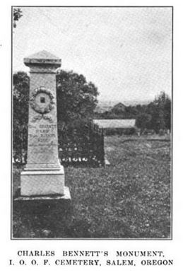 |
| The monument (also at top) in 1914 Ladd & Bush Quarterly |
 |
| Ladd & Bush Quarterly, 1914 |
[S]ome Klamath Indians came into the area and stole one of Jesse Looney’s prize mares. The Looney’s established their land claim near the southern base of the Red Hills (Salem Hills, the red earth is called Jory Soil) in 1843 and brought horses with them from the east.
A call went out to the local volunteer militia rangers, under the command of Captain Bennett. Bennett was not at the skirmish and it was E.A. Robinson who organized and marched the men 12 miles to (Battle) creek.A call went out to the local volunteer militia rangers, under the command of Captain Bennett. Bennett was not at the skirmish and it was E.A. Robinson who organized and marched the men 12 miles to (Battle) creek.
They charged in an undisciplined manner, and fired blindly into the brush at the Klamaths. One Indian man was wounded through the thighs while the rest escaped. Robinson called off the attack and the mare was found tied to a tree near there. After the battle a meeting was held between the participants, and in apology for injuring the Indian, the rangers paid him a horse and several blankets. He survived his wounds and was seen at The Dalles sometime later.
 |
| The 1852 GLO survey map of the Battle Creek Park area Note Jory, Minto, and Pringle family names. The "battle" was a little to the west, I think. (Notes in red and yellow added) |
This Battle is perhaps the first of many conflicts in the Willamette Valley between the tribes and the settlers. Generally the settlers were illegally taking land and settling well before there was any treaty or understanding about payments for the land by the United States. The tribes retaliated many times, for the over-hunting of the area by settlers, by stealing property of the settlers...[The settlers] treated the Tribes as if they were savages and never sought to understand them.The park may be a missed opportunity for more public history, especially with the recent Memorandum of Understanding with the Confederated Tribes of the Grand Ronde. The relation to Virgil Pringle's settlement also suggests Waln Creek might be a later name for that particular creek. This little confluence is an interesting site, and it may not be getting enough attention for its history.
(For a brief note on the Bennett Hotel, where the Masonic Building is today at State and High, see here also.)
The Battle Creek Park Plan includes a disc golf course and floodwater detention. Neighbors have criticized the plan as not having enough storage capacity for floodwater. Given the City's attitude to trees, it is not easy to assume they have a sufficiently robust sense of threat from flood, especially as "100 year" events are statistically more common than once a century now with climate disruption.
The other thing to observe here in particular is that the perimeter is not very rich with connections, and the only hard-surfaced path takes you circumferentially along the edge. It's not very helpful, then, for north-south connectivity, and this may also be a missed opportunity. The plan really functions like a superblock, very much fenced off by back yards. I wonder if it will feel very safe. Hopefully disc golf will create enough regular traffic that it will.
 |
| Master Plan - disc golf and flood detention The path skirts the perimeter and does not offer any direct north-south connectivity on a central axis. |
When the proposal for the TIF District came before the Planning Commission, they encouraged
the Council to consider recommending that the developer increase the percentage of affordable units in exchange for the property tax rebateAnother person submitted similar public comment. The Staff Report and supporting materials are rather uncritical, already assume a TIF is the best solution, and would not give an independent-minded member of Council sufficient grounds for considered support or opposition to the plan. This TIF concept looks a little like a developer give-away with ex post facto justification rather than the best solution arrived at as the conclusion of a rigorous analysis. Maybe there's been more analysis, but the Staff Reports have not discussed other concepts discarded as inferior. We know it's hard to get affordable housing built - but why is this the best solution? And if it is merely an experiment, Council should know the grounds on which it will be assessed and which will inform any next iteration and attempt. (See previous notes here and here.)
The Nursing Home at the former Boise site is delayed again:
The proposed Fourth Amendment (Attachment 2) will revise the Project commencement date from March 1, 2020, to January 1, 2021, and completion date from March 1, 2021, to October 1, 2022....Salem LTC Properties granted construction access across their site at no cost for the Pringle Creek work and will be allowing no-cost access to Riverfront Park for construction of the Gerry Frank Rotary Amphitheatre.I guess if there is no rush to build the Nursing Home, then it works out for everybody to allow the City and Rotary to use it for construction staging during any delay on the Nursing Home.
Bullets for the rest:
- Why are we still allowing carbon polluting drive-thrus? There's an information report on a drive-thru coffee shack on Fairgrounds Road.
- Why are we still pursuing carbon polluting air travel? There's an application for a million dollar grant Salem is pursuing.
- A contractual detail on the drinking water aquifer storage project under Woodmansee Park.
- A contractual detail on Hope Plaza, the redevelopment of the old bus station site next to the Center for Hope and Safety.


No comments:
Post a Comment