When the City announced this week with great hoopla a new interactive map for "Safer Streets," the first thing that came to mind was the busted up crosswalk stop sign on Market Street at Winter, on the formal Neighborhood Greenway, and right at the Elementary School.
 |
| They finally gave up on replacing the sign! School crosswalk on Market at Winter |
Some combination of the City and School District seem to have decided to abandon the stop sign and stop replacing it because drivers keep hitting it.
But that should be a sign the crosswalk needs further hardening! It needs more, not less. Removing the sign is bass-ackwards.
So the intersection of Winter and Market was a logical place to comment and make a request.
 |
| At Winter & Mission: Rejected! |
But even though the map's name is "City of Salem Neighborhood Traffic Concern Reporting Portal" you can't report this! It kicks you out to another map and set of forms. Screw that. That's just another, counterintuitive barrier, more administrative sludge.
The City should consolidate maps and just employ one single reporting tool.
The whole thing is too limited, in fact. The City clearly envisions it for spot reporting on a very limited menu of problems. Citizens are already enlarging its scope, and some tried to focus more on corridors.
Even though 17th Street had a 5mph speed reduction posted in some places, the wide cross-section still induces speeding, and a citizen chose the intersection of 17th & Nebraska, where there is already an enhanced crosswalk, to say more is needed.
 |
| At Nebraska & 17th: Corridor request |
Another person chose the intersection of Rural and Commercial, where there are lots of students on foot, a cluster of driveways and parking lots with turning conflicts, and the whackadoodle split into the one-way couplet, to say that the whole of Commercial needs calming.
 |
| At Rural & Commercial: Corridor request |
Nearly a decade ago the Commercial-Vista Corridor Study identified this problem with data, and while a few enhanced crosswalks in the segment are scheduled for construction, speeding remains a real problem.
 |
| 4245 people/day speed more than 10mph over limit here (Dec 2014, red comments added) |
The City already knows about a lot of these areas, and soliciting another round of comment may just be a way to give the illusion of caring.
A third comment, reiterating problem of speeding on the High Street corridor, was on High at Lincoln.
 |
| At High & Lincoln: Corridor request |
This area has seemed like a great candidate for a diverter, something that would allow people biking to pass, making High Street a much better way for bike travel, and would enforce a turn for people driving. Such a diverter would reduce much of the cut-through driving that ignores the sign at Mission and High.
 |
| "Local traffic only" |
As with the note on 17th at Nebraska, there is evidence in some places that a first level intervention/countermeasure was not enough, and more is needed.
On 21st between Market and D there is a cluster of comments, and one of them requests speed bumps.
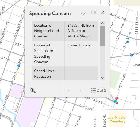 |
| More speed bumps for 21st Street |
But the City already installed a set of them. More calming, then, is likely necessary.
 |
| There are already speed bumps on 21st here |
Citizens should just blanket the map with comments, not just on neighborhood streets, but on zoomy stroads as well. Speed reduction is even more necessary on them!
The City should consolidate maps so there is one single reporting tool for traffic concerns.
And the City should understand that we have a system problem with speeding and that spot fixes alone aren't enough.
 |
| from Walkable City Rules by Jeff Speck |
 |
| Yes, it probably was |
If we want to hit our climate targets, which include VMT reduction, we should not be afraid of
slowing drivers and driving. We need to make walking, rolling, and
busing more delightful, and not spend so much time, energy, and money on
making driving more delightful.
At the City:
- The announcement, "Residents Asked to Help Shape Safer Streets and Pedestrian Crossings in Salem"
- The webpage, "Safer Streets"
- The interactive map itself, "City of Salem Neighborhood Traffic Concern Reporting Portal"


3 comments:
Back in March, people may recall, SKATS solicited comments on unsafe streets and places with a crowd-sourced mapping project.
Now there is this.
One of the things that is so dismaying is that the information is there. The problem isn't that the City doesn't know where speeding and crashes occur. The problem is political will to make changes, curb speeds, and disassemble the paradigm of flow and "congestion relief."
So we have another round of public comment as a kind of substitute for doing very much.
My problem with this exercise is that the most obvious solution to speeding on arterials -- speed on green cameras -- is not even given as an option. The other obvious solution is a road diet, and that is not an option either though maybe "lane striping" and "on street parking" would constitute a road diet, though many people won't make the connection. "Road diet" and "Speed cameras" should be options here. I tried to register a concern about speeding on S. Liberty into downtown but none of the solutions seemed right.
You point to another problem with the map and similar exercises. A few years ago, and I have tried for a few months now to find it and maybe you will know, Strong Towns wrote on the proper role of engineers. Citizens should articulate values, like "we want slower speeds here," and engineers should pick the appropriate countermeasure or other design solution. There was a neat table in the post, one column for engineers and one for citizens, with the appropriate areas of responsibility listed in each.
We do it backwards. Currently we have engineers picking values, like high volume/capacity ratios and levels of service, and citizens are spitballing with solutions that are often not appropriate to, or best for, the particular location. (Stop signs everywhere!)
This mapping project makes citizens responsible for design solutions and countermeasures. So much near-expert opinion is necessary to navigate the map and its comment form! Citizens shouldn't have to do that. We should be able to say, "I want a road designed for 20mph here," and that should be enough. Then the engineers will make it so.
Anyway, given the map as it currently is, you are right that photo radar (etc.) should be an option! But the options shouldn't even be necessary.
Post a Comment