Showing posts with label New Police Station. Show all posts

Monday, April 11, 2022

Commercial Street at UGM and the Police Station, a Survey, and a Congestion Plan: At the MPO

The technical committee for our Metropolitan Planning Organization meets on Tuesday the 12th. They have information on a segment of Commercial Street, some interesting survey results, and bits on the approach to congestion and project scoring.

TIP Amendment

One of the items in the meeting packet is a TIP amendment.

Start of multi-use path along new UGM facility
New Police Station in background
(at D and Commercial, 2021)

Alas, the TIP amendment is really only a formality and a bit of a Potemkin instance of public process. The Staff introduction says, "This is considered a full amendment because it is adding mile points on a new section of roadway." But otherwise it doesn't really meet the spirit of a substantive amendment. It's hard to imagine any amount of public comment that might cause the project to change.

As you can see at top, the City already required a multi-use path as part of the new UGM redevelopment between D and Division along Commercial Street. (See also "City Fails to Solve Charlie Foxtrot, Uses Kludge at Front-Division-Commercial Intersection.") In the amended project there is no real opportunity for a new bike lane or a new configuration. There's not a decision point with options on which the public might comment or show a preference.

Tuesday, February 8, 2022

New Strategic Plan for Police Frames Safety in Odd Ways

Apparently some time this month or very late last month, Salem Police released a new Strategic Plan, and it could use another round of revision.

The very first topic - the very first! - is homelessness under the heading of "safety."

Homelessness as #1 safety problem

Seeing homelessness as a problem of criminality is not very helpful. In tone and in substance that is misguided.

The underlying problem is that we don't have enough housing and affordable housing. Problems with mental health and petty crime are greatly intensified in this context. The primary problem is not crime. The crime will be much easier to police when we handle the housing adequately. The Plan should lead with a clear statement that we lack housing, and "homelessness" should not probably be the leading item in the Plan's structure.

Then the next heading is traffic safety.

Crash yesterday, in the paper today

Cars and their drivers kill and seriously injure more people than homeless people kill and seriously injure. But in part because we scurry and clean up the mess and carnage of a crash, and it doesn't linger the way the mess of a camp does, we quickly forget the magnitude of the violence, even when unintended. We remember the persistence of nuisance, not the more transient and catastrophic violence of crashes.

Saturday, December 11, 2021

City Council, December 13th - Misunderstanding Degradation in LOS Analysis

Council convenes for the last time in 2021 on Monday, and they have a technical fix for a Comprehensive Map Amendment process that is worth more attention.

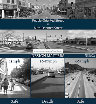
Strong Towns on design, comfort, and safety

The problem the fix seeks to solve in fact evades the larger matter of our autoism, and if an amendment like this is necessary, and given the exigencies of our climate emergency stronger action will be necessary in the future, the City is missing an opportunity to rethink the autoist hegemony of Levels of Service analysis. The Oregon Highway Plan policy references "avoid[ing] further degradation," as if the primary "degradation" was congestion and not tailpipe and carbon pollution, brake and tire dust pollution, and the lethality of car speed and power. Cars, their speed, and their pollution degrade the walking, biking, and busing environment, even the living environment, but the OHP only considers the supposed "degradation" to drivers in congestion and delay. There is enormous autoist bias here.

Tuesday, July 20, 2021

City Fails to Solve Charlie Foxtrot, Uses Kludge at Front-Division-Commercial Intersection

The City really wanted us all to think well of the changes they were making in order to have Division Street two-way at the Police Station.

Look at all the "neat" changes!

Last year in a release the City announced the changes as "improvements":

These street segments have been closed as crews completed several traffic, pedestrian, and bicycle safety improvements. Improvements include new traffic signals, additional on-street parking, landscaping, lighting, sidewalks, and crosswalks.

The bike map is full of caution/red here
and especially Division/Front/Commercial

The City had a great opportunity to fix the compound intersection at Front/Division/Commercial for people on foot and on bike, especially with its proximity to the new UGM facility, whose clients will rarely be driving, but the City did not do this. At the very least they substituted one set of problems for another. But more, they may have made the existing Charlie Foxtrot even more foxtrotted up. (Remember the chicken crash in 2013?) 

Friday, November 20, 2020

City Council, November 23rd - Affordable Homes and German Baptist Church Project

Council convenes on Monday the 23rd, and on appeal from Grant Neighborhood Association they'll be reviewing the Planning Commission's approval to redevelop the First German Baptist Church of 1928 into 19 affordable homes.

First German Baptist Church of 1928
Recently, Evergreen Presbyterian Church (2014)

That will need to be argued on the merits, but former Councilor Kaser's resignation and agreement with the State Ethics Commission does in fact cast a shadow on the review: Council's decision to accede to the Grant Neighborhood Association's request to deny funds in an earlier proceeding appears to have been conducted in some degree of bad faith.

A finding of one violation
of ORS 244.120(2)(a)

Even though in a preliminary consultation the City Attorney may have suggested she was in the clear, it was obviously a questionable situation, which is why she requested guidance from the City Attorney in the first place. She could have invoked the proverbial "abundance of caution" and declared a potential conflict even if she did not believe there was one in fact. She could have covered her bases. But instead of choosing the spirit of disclosure, she chose the spirit of non-disclosure and secrecy.

Sunday, June 21, 2020

City Council, June 22nd - Police Reform

The first round of reform was not enough
Minneapolis Star-Tribune on Saturday
In addition to the final budget approval, which at least theoretically could be adjusted, Councilors are bringing several reform-minded motions to Council on Monday:
Changes and Success in Camden, NJ - June 15th

Over-militarized policing is a problem
June 15th

Another barrier to reform - June 13th
Most of these, however, are preliminary to any actual policy changes. So it is interesting that they are not directly talking about a pause in the growth of hiring or reducing or reallocating any budgets or making other institutional adjustments. Several of the comments submitted to Council call for stronger action than a new study or work session. The move to a new Police Station and process for a new Chief also makes this moment, right now, a good time to initiate change. At the same time, since here in Salem we have not previously had a widespread debate at Council on policing, there is not a package of reforms that has already been on the table, as has been the case elsewhere, and there may indeed be necessary preparatory work.

Friday, May 29, 2020

New Station needs New Chief: Take City Survey on Next Leader

New Building, New Chief
The City's starting the public portion of a search for a new Chief of Police.
Ralph Andersen & Associates is beginning the recruitment process for the new Chief of Police for the City of Salem. The City of Salem invites you to take this survey regarding the future of the City of Salem Police Department. The survey will begin an open conversation about what is needed in the next Chief of Police.
Chief Moore has seemed like a nice and responsible fellow. Yesterday he published an open letter about Minneapolis saying "we do not teach any of our officers to control a suspect’s actions by kneeling on their neck." That is a good statement, but the initial frame of "tragic events across the nation" is not wholly adequate to the structural elements in play here. It's not some random tragic event, but is one instance of a deep and enduring pattern across the country. The frame of tragedy operates as something of a euphemism in this case.

Front page of Minneapolis Star-Tribune today

Friday, February 28, 2020

Detours and Closures on Liberty, Division, and Commercial for Police Station this Spring

The front page today has a great shot of the charlie foxtrot on Commercial at Front and Division. It was a terrific idea to send the photographer to the top of the new Police Station.

Great image of the charlie foxtrot on Commercial
at Front and Division - front page today
The photo supported a longish piece on the street closures and changes coming to the area because of the new station. It was nice also to read more reporting than merely churning the City's press release.

Street closures - via City of Salem
Here's the City's release:
Beginning Monday, March 2, 2020, Liberty Street NE between Division Street NE and the Mill Creek bridge will be temporarily closed to all through traffic. The northbound lane on Liberty Street NE will re-open in early April. Pedestrians and motorists are asked to use caution and plan for some delays as traffic is re-routed toward High Street NE and Commercial Street NE.

This street closure is necessary for the construction of streetscape and pedestrian and bicycle safety improvements adjacent to the new Salem Police Station. Additional street closures along Liberty Street and Division Street will occur in phases through June 2020 as follows:
  • Division Street NE and Liberty Street NE intersection (closed late March through early April),
  • Division Street NE and southbound Liberty Street NE between Division Street NE and the Mill Creek bridge (closed late March through early June).
This construction will change the streets and traffic signals to improve access and traffic circulation in the area. The work will provide additional on-street parking, landscaping, street lighting, sidewalks, and stormwater improvements.

Street closure dates will be posted on digital signs in the project area prior to the closures.

Tuesday, August 20, 2019

Overruns on Police Station were Always Predictable

Yesterday Salem Reporter had a piece on the cost inflation at the new Police Station.

"'Snowballing-out-of-control': How the price rose by millions on Salem police headquarters" is interesting in many ways, but here it's worth focusing on the City's admission that "the original estimates were too low...[and] not high enough."

The implied context might be a little disingenuous, however, and the story might dwell too much on the City's perspective and not enough on criticism during the process as well as the academic study of estimating and project management. There should be less surprise about the overruns.

An early concept used only surface parking, not a structured garage,
and was for a 75,000 square foot building.
(Council worksession presentation, June 3rd, 2013)
The focus on palateableness for voters may cast the City in a light a little too charitable. During the debates earlier this decade, citizen criticism was not that the "estimates are too high," as if the project had bad or inaccurate estimating, but that the project was too big and too fancy. It was about scope, not estimating. Criticisms of the cost sometimes also included proposals for cheaper and smaller construction, not quibbles over the accuracy of estimates for the bigger and fancier proposal. Criticism was of the underlying plan, and some of the modeling behind it, not of the quality or accuracy of estimating on the plan once baked. The quote from the City seems to retcon the nature of the criticism.

Friday, July 5, 2019

City Council, July 8th - Daylighting Pringle Creek

Council meets on Monday and a slate of three tranches of Urban Renewal funding leads the way.

View towards the Minto Bridge from Commercial St Bridge -
with retaining wall and concrete cap
Most interesting here is action on daylighting Pringle Creek and preparing for the path system in the former Boise project.

Also worth notice is increased funding from URA funds for both the Police Station and Division Street at the Police Station.

The Cthulhu keyboard and fish ladder
to be removed
 (Back in 2014)
You may recall a brief note back in April that the City was working on plans to remove the concrete cap over Pringle Creek between Commercial Street and Riverfront Park, in the area of the former Boise Cascade plant. A year before that, in April of 2018, the Nursing Home project was announced as delayed again, and we saw the first public discussion of cap removal.

Wednesday, May 29, 2019

Weird Art: The Watchful Eye at the Police Station

Did you have a nice weekend? Council met yesterday and SKATS adopted the 2019 RTSP and maybe we'll backfill with a couple of brief notes. But maybe not. There didn't seem to be much to say on them, and it was mostly a nice weekend, though not perhaps quite as sunny as it has seemed it might be.

Today we are getting the first public look at art for the new Police Station, the Eye of Sauron Salem.

What is this? A weird celebration of the Surveillance State?
What were they thinking? Maybe some other reading and interpretation of it - apart from the interior text embedded in or projected on the thing - is intuitive and obvious to you, but the first thing that comes to mind is an eye. The second things are the Mason/illuminati eye on our dollar bills above the pyramid, and "Big Brother is watching you," and of course Sauron. This looks like a strange and creepy instance of public art with all the wrong kind of messaging.

The Public Art Commission shared little in public about the process of selection, and this definitely looks like an instance where more public comment would have helped things greatly.

With a scheduled event, the ornamental emptiness will be full!
Anyway, there's a "Meet the Artist" event in the Conference Center Sculpture Garden today the 29th at 5:30pm. Maybe more about the sculpture concept will be published and it will seem less "sauronic."

Wednesday, March 13, 2019

City Tries to Leverage New Bike Lanes to Greenwash Tree Removal near Police Station

On Thursday the 14th the Parks and Recreation Advisory Board will conduct a Public Hearing on the proposal to remove trees on Division Street between Liberty and High in a project related to the new Police Station.

Agenda
One of the reasons adduced for the removal is the prospect of new bike lanes on Liberty Street, which would result "in a reduction of available on-street parking." So the City proposes to hollow out the curb strip, and install new angle parking where there was parallel parking before.
New bike lanes as reason to justify tree removal - Staff Report
Over on Facebook, tree advocates have posted more information and have rightly suggested that we should no longer routinely countenance trading mature trees for new parking in the public right-of-way. At this moment, maintaining tree canopy is a higher value than adding to the stock of subsidized car storage.

It also seems relevant that there are no bike lanes proposed for Division Street, where the trees are proposed to be removed. The bike lanes are actually on Liberty Street, a little distant from the trees in question. Removing trees on Division gains no space directly for any new proposed bike lanes. The relationship the City posits between tree removal and new bike lanes is much less direct.

So let's look at what appear to be a cascading set of changes just off Division Street. Because these changes affect other projects, they deserve more notice and analysis. The City has been very quiet about them. One of the biggest is extending two-way sections on Liberty and Division here. The Division Street bit seems unproblematic, but Liberty bit seems more complicated, and it impacts the Union Street greenway. The bike lanes on Liberty Street also terminate awkwardly and do not connect adequately with the wider network. Overall the project appears autoist, with bike travel very secondary and not at all integral.

Wednesday, December 19, 2018

Trees at Risk along New Police Station: Old Parking vs New Parking

You might remember that an older word for the curb strip was "the parking," a tiny strip of park or the action of making the strip into a park, and it is funny to see the modern sense of parking threaten to engulf the older.

Beautify the Parkings: September 19, 1910
Over on Division Street by the new Police Station, tree advocates are upset that the city proposes to remove several mature trees in order to make room for angled car storage.

from The City, via FB
The Director of the Urban Renewal Agency says
Construction of the Police Station will reconfigure traffic and add bike lanes, which will eliminate 20 on-street parking spaces on Liberty Street. The current plan will replace the parking spaces that will be lost on Liberty Street with spaces on Division Street, and also add about ten new spaces to meet increased parking demand in the area.

Adding these spaces to replace lost parking and meet new demand requires a choice between maintaining existing tree canopy, or meeting parking needs. Without diminishing the value of existing tree canopy, street trees are a community asset that can be replanted and which will regrow over time. Parking spaces are a different form of community asset, and they cannot be replaced in the same way that trees can. Eliminating parking spaces will not eliminate the current and increasing need for them. While we need to remove several mature street trees to make room for the parking improvements, there will be an overall net gain of trees in the neighborhood when the project is complete.
There's a lot going on here.

Friday, September 7, 2018

Traces of Old Hotel at New Police Station Site? Archeology Day Offers Glimpse of Older Salem!

The City just announced a nice moment (and probably also calculated for good PR) at the new Police Station, a public archeology day.

Lodging House, Mill Race on corner, Corral on alley
Liberty and Division, 1895
The area for the Police Station is between centers of the earliest urban activity in old Salem: Along Mill Creek and at Boon's there was early activity in the north, and then downtown, along Pringle Creek, and at Willamette University.*

The Police Station site is sandwiched a little between them.

I don't know of any photos of the block, but by 1895 the Sanborn Fire Map shows a reasonably well developed residential area.
 
1895 Sanborn Fire Map
On the corner of Liberty and Division also note the "Lodging House" and in back off the alley a corral. There are also outhouses.

Running down the middle of Division is an old Mill Race we have lost track of!

Friday, July 27, 2018

Proposal for Opaque Fencing at New Police Station Deserves Scrutiny

If you weren't able to attend the Open House for the new Police Station a couple nights ago, the City's published the Notice for Design and Site Plan Review at the Planning Commission.

From Commercial and Division
high-crash corner from zooming on Front Street
 buffered with landscaping (remember the chickens!)
Mostly the plan looks pretty good. It'll be interesting to hear of any real criticism on the design (as distinct from comments on the cost overrun, which has already got some attention, and likely will get more).

Two pods of bike parking proposed (red comments added)
Detail from view from Liberty and Division shown below
 On our narrow bike interests here, they ask for an adjustment on bike parking:
Section 806.060(a) indicates that bicycle parking areas “shall be located within a convenient distance of, and shall be clearly visible from, the primary building entrance.” and that be located within “50 feet from the primary building entrance.” We are required to have 21 bicycle parking spaces and will be providing accommodations for 22 bicycles, 16 (public) will be located on the front or Division Street side of the building and 6 within the secure parking area on the north side of the building. It is not practical to locate all 16 public bicycle parking next to the main entry door; we are proposing that half (8) of these spaces be located near the main entry and the other half (8) will be centrally located within the public plaza. Placing bicycle parking at the entry and within the public plaza provides better balance for the building and the plaza users. It also allows for better circulation and accessibility at the public entry and in the plaza area. Both of these locations are easily accessed from the public right-of-way. We believe this design approach better meets the intent of the standard which is to locate bicycle parking so that it is convenient and visible to the destination which may be the plaza rather than the actual Police Station. Programming needs and design constraints within the secure parking area do not provide adequate space for the 6 bike parking spaces to be within 50 feet of the primary staff entrance; however, these spaces are located within 50 of a secondary building entrance and adjacent to the parking garage thereby having access that is convenient to bike parking.
That seems totally reasonable and is a sensible reading on the "intent of the standard."

Blank Walls and Fencing

This is a lot of blank wall along Commercial Street
But more generally, there is in fact one questionable item. They also ask for a completely opaque fence around the parking area.

Friday, July 20, 2018

City Council, July 23rd - Safe Routes Applications and More on State Street

Council meets on Monday and there's a lot on the agenda. Revisiting the State Street Plan and approval for applications to the new Safe Routes to School funding program lead our interests here. There are several other items that involve parking or transportation.

So it looks like Staff are dissatisfied with the way the State Street Plan shook out? Not only is the Plan back on the agenda, Staff appear to be hinting strongly for some additional tweaks.

The report says "Staff has provided additional information below for consideration." (hint, hint)

From a previous presentation and earlier round of height reduction
Mostly it's about building height and ensuring with more detail that the proposed changes accommodate both residents of the Historic District's wishes as well as the larger goals to spur redevelopment. The trade-off of a reduction abutting the District and an increase elsewhere seems like a good one.

From the Staff Report:
  • The maximum building height abutting National Register Residential Historic Districts could be lowered to 50 feet in the MU-2 zone to ensure that the lower height applied to all MU-1 and MU-2 properties abutting the Court-Chemeketa Residential Historic District.
  • A maximum building height of 45 feet may or may not accommodate a four-story building that complies with the development standards in the MU-1 zone. Further reducing building heights could hinder the development potential of properties on State Street. It could also result in the development of fewer multifamily units, which are needed in Salem. The 2015 Housing Needs Analysis specifically determined that the Salem area has a projected 207-acre deficit of land for multifamily housing based on a 20-year population projection.
  • Staff conducted outreach to property owners during the State Street Corridor Plan project to discuss the proposed MU-1 and MU-2 zones and how their properties, if rezoned, would be impacted. In those property owner meetings, staff first presented the proposal of a maximum height of 65 feet in the MU-1 zone and later presented the lower 55 feet maximum height. For properties in the Commercial Office (CO) zone, this represented a reduction from the maximum building height of 70 feet allowed today. (The CO zone is adjacent to the Court-Chemeketa Residential Historic District between 14th and 17th streets). Staff did not propose a lower height of 45 feet when meeting with property owners that could be rezoned to MU-1 or MU-2.
  • The overall maximum building height in the MU-1 zone could be increased to 65 feet, as previously proposed by staff, to offset a further reduction in height to 45 feet for properties abutting National Register Residential Historic Districts. This would help ensure that the MU-1 zone retained its overall development potential, aligning with findings of the economic analysis conducted as part of the State Street Corridor Plan project. That analysis found that there is more momentum for redevelopment in this western half of State Street due to its proximity to catalyst areas such as Willamette University, the State Capitol, and downtown.
Still, even with putting all the parking in back so there's no mass there to cast a shadow, the project team earlier in the year showed a four story development of the sort that is desired, but still didn't pencil out.

Friday, July 13, 2018

Save $2M? Ditch the Costly Structured Parking!

City wants to use $2M in Urban Renewal Funds
The City's been a little stingy on posting updates more detailed than breezy "building buzz" videos on the new Police Station, so it was interesting to read the article about the value engineering and proposed new funding. (They finally posted the basic plan and survey results. The construction cam has seemed to be stuck for several days now, and is not updating.)

One item of context left out is that on the $100 million road bond in 2008, the City consistently secured bids under budget. In total bids seemed to come in at about 80% of the budgeted amount. This 20% gap allowed the City to rope in a bunch of smaller projects and by count (not by dollars!) added about 50% more projects.

That was smack dab in the middle of the Great Recession.

Now things are different, and it's no surprise that we see the opposite in this latest bond project.

Maybe there's a story of mismanagement or error here, but at the moment this does not seem to rise to that. Instead it looks like a story of the cyclical vagaries of our economy.

Moreover, the value engineering and proposal to use Urban Renewal Funds to fill a gap actually look to be within the range of things on which reasonable people can disagree.

From the paper:
As city officials try to make the place more useful to locals, the largest chunk of the July request — $1,197,000 — is poised to pay for a big community room at the station. Other expenses include public restrooms ($398,000), a plaza ($250,000) and artwork ($240,000), bringing the grand total to $2.085 million....

Officials had earlier allocated $4.3 million from the area's urban renewal fund for street improvements, such as opening portions of Division Street NE and Liberty Street NE near the facility to two-way traffic....
It is not outrageous to think the community room, public restrooms, plaza, and artwork in the public space (not anything on the interior!) could meet standards for urban renewal funding.

Tuesday, April 3, 2018

New Paint for the Dome Building? A Crosswalk on Division? - Walking Bits

Did you get out for a walk on Saturday last weekend? The weather was good, and in the afternoon the sun came out and it became great. The Cherries at the Capitol and elsewhere around the city were in full bloom and just beginning to drop petals. Here's one slide show from midday, before the sun was fully out.

Elsewhere there were other things to note also.

It looks like the Dome Building is getting a paint job to match the Kirkbride Building.

A new paint scheme for the Dome Building?
Would match the Kirkbride!

Dome Building in winter 2013, South facade

The main Kirkbride Building in 2012
That color scheme on the Dome Building would really unify the two buildings across Center Street. I look forward to the finished state.

Thursday, March 22, 2018

Landscape, Circulation Rank Low on Police Station Priorities

Last night the City and project team shared some results and preliminary design concepts from the survey this winter.

The current concept, via Twitter
They've published a full report on the survey, and I want to drill into one small portion of it.

None of the elements in the survey that directly involve transportation were ranked very important. Car parking and transit ranked right in the middle.

Survey rankings, comments in red added
The elements that specifically involved travel on foot, "landscape" and "campus circulation," whether at trip-end after a car or bus ride, or as a full walking trip, were ranked very low.*

Saturday, March 17, 2018

Demolition Party Cues up the next Open House for the new Police Station

I know it's orchestrated PR, but it's still pretty great to see the Chief of Police tear into the old building and to have something of a demolition party for the new Police Station.

It's relief to have the decision made and to be able to move on with making the project as fine as it can be.

One element to consider is how the street front along Division might be improved. The construction cam the City's set up will give an excellent view on the corner of Division and Commercial and a half-block section of Division to the alley.

This morning's view, with no parked cars at all, shows starkly how inert this area is at the moment.