
Our local Metropolitan Planning Organization meets on Tuesday the 23rd, and they have two big drafts to consider. They'll look at the formal work plan for the coming year, and they'll release the formal public draft of the 2019 Regional Transportation System Plan.
The Work Plan
Just a few things to notes in passing on the work plan.
The section on the SRC has not been updated since the Council vote. It's unclear whether this is an accident or by design. It may be a sign that there remains hope of some last minute intervention to revive the bridge as the preferred alternative.
 |
| Information on the SRC is badly out of date |
The Work Plan makes it clear that the study is more of a negotiation, between County and City, and is less a matter of engineering details.
 |
| On the same page? Coordination mostly on Cordon Road |
Finally, on travel models, it has become clear that the matter of false precision and margin-of-error needs to be highlighted.
 |
| We need more on margin of error in traffic forecasts |
 |
| This population forecast for 2043 has no margin of error |
This may be long and tedious, but we'll just march through it. You may recall some notions about lines for comment. As we read the thing, we'll see how apt they in fact are. Maybe others will emerge.
- Shifting away from hydraulic autoism
- And related, moving off of "Levels of Service" analysis
- Thinking more about Goal 7, greenhouse gas emissions, and climate - especially since the latest estimate is that 57% or more of our emissions come from transport
- Rooting out vestiges of the SRC and its ancillary projects. We've seen how in Portland ODOT was able to smuggle into the I-5 Rose Quarter analysis hidden assumptions from the Columbia River Crossing project. ODOT or the MPO might do the same here.
- Generally boosting walking, biking, busing, and things like Safe Routes to School programming
 |
| Everything must be read in its shadow - via NOAA |
The cover of the plan shows people traveling on foot, by bike, and by bus. There are cars, too, but they are not the only focus. That's nice. If only there was less signalling and more substance here!
 |
| The cover's focus on walking, biking, and busing is absent |
 |
| We need to reverse the priority: Less on bottlenecks, more on congestion and demand management |
 |
| The discussion of the future misses on GHG |
 |
| "Cooperation" privileges recalcitrance and reactionary politics |
This plan has evolved through a process that ensures that transportation planning activities affecting the overall regional system are continuing, comprehensive, and cooperative.But what this really means is that members with reactionary politics can kill or shape priorities in ways that ensure that the plan does not work "for all the members of the community." The rhetoric is "we're all in this together," but it instead protects autoist priorities.
 |
| Translation: We will only do the minimum required by law |
 |
| Goal 7 has been very much watered down |
As I read it, the whole framework of the RTSP needs a better focus on greenhouse gases, and "winning" an improved Goal 7 would not by itself accomplish this. So I am inclined to think that would be something of a Pyrrhic win, and therefore not worth focusing on. This is a weakly held opinion, though, and you might have a very different reading and conclusion. It's not possible to be dogmatic here.
Separately there might be more to say about safety, but that'll be for another time. Maybe others will zero in on this.
Chapter 4, Existing System
 |
| Look at the East Salem numbers |
 |
| From Chapter 9 on "outstanding issues" |
 |
| Map 4-6 shows gaps in the bike lane system (also Map 5-1) |
But conceptually as "gaps" that real people might experience, the map is thin. Take Kuebler and Cordon Road, for example. They are striped with bike lanes. They have complete facilities and are counted as part of the system. But they are not at all comfortable, families would not use them, and they still constitute gaps for all but the most confident and strong of cyclists. We really should have a "level of stress" analysis layered over this.
 |
| An early pass at a levels of stress analysis (2011 UO SCI study) |
One solution was to create bicycle routes that used local streets where the volume and/or speed of the motorized traffic is lower. (This is similar, but much less expensive, to an earlier paradigm that advocated for the creation of a bicycle network that was totally separated from motorized vehicles). These have a variety of monikers such as ‘bicycle boulevard,’ ‘family friendly bikeways,’ ‘all ages and abilities (AAA) bikeways,’ and ‘neighborhood greenways. It was recognized that in some areas and locations these could not be implemented, such as in downtowns and along commercially oriented streets.Chapter 5, Needs, Gaps, and Deficiency Analysis and Identification
 |
| The increasing crash count tracks with with increasing VMT |
 |
| Too much blaming the bad driving behavior |
Instead, our commitment to congestion relief implies speeding cars along, and this is fundamentally in tension with any commitment to safety.
 |
| Rickroll on the SRC: Never gonna give you up |
And here is what in many ways has seemed to be one of the most important, certainly one of the most underrated, problem areas.
 |
| Map 5-4, Seismic Vulnerability of Bridges (note this is NOT existing bridge condition) |
Chapter 6, Financial
(I didn't see anything here. Maybe you will.)
Chapter 7, Proposed System
 |
| $20 million slush fund for the SRC |
But the other list, the "included" list, is much larger, and is a list of projects SKATS thinks will find future funding. It's not a pure wish list, but it's a kind of wish list with real world constraint. It's a good guesstimate. It is also appropriate to argue for inclusion/exclusion of these.
The most interesting item is a $20 million slush fund for the SRC. Further detail from Chapter 9 clarifies this:
For the RTSP update in 2019, three projects that were part of the Salem Alternative LPA [locally preferred alternative] are identified in this financially constrained Plan: constructing Marine Drive from Glen Creek Road north to bridge ramps at Hope Street NW (S297), widening and realigning Front Street between River Road North and Norway Street NE (S096), and including $20 million for use in preserving and purchasing right-of-way associated with the bridge (R001).As a count of projects this isn't so bad. And each of these three are identified as "included" projects only; while they participate in the "financial constraints," the constraint is "reasonably anticipated" funding, not actual funding committments. So these are projects that are available to be submitted for funding, but there's no path yet to actual funding.
But having these projects in the plan may make their traffic assumptions available to leverage other future projects. Even though the SRC is not yet built, justification for some other large road project might model traffic as if the SRC already existed in some future scenario.
This is an important move in ODOT's deceptive plan for the I-5 Rose Quarter widening.
It would be better for SKATS to take out all of the SRC vestigial projects and to have to put them back in when there is an actual plan "reasonably" certain to move forward.
Chapter 8, Impacts
 |
| Widen intersection = medium = adding sidewalks? |
So I'm not entirely satisfied with this set of theoretical distinctions, even if they have to be "rules of thumb."
 |
| Avoid and reduce car trips! |
Chapter 9, Outstanding Issues
Even if the MPO at present did not commit to any kind of strategic thinking about greenhouse gas emissions, this last chapter on "outstanding issues" would be an appropriate place for staff to outline, even if in disagreement with the Policy Committee's own commitments, potential future actions on greenhouse gas emissions.
This might be a place to register a kind of minority opinion or dissent or whatever you might call it. In the introduction to the chapter it even mentions that "No consensus solutions are currently identified to address these issues...." So this would be a good place to lay the groundwork for future revisions to the RTSP. It is less speculative, really, than current thinking about robot cars, for example, and AVs get a paragraph in the chapter.
In any case, the absence of a section on greenhouse gas emissions in this section is a meaningful omission.
Just a Footnote
In the appendices is a chart of building permits, and I don't remember seeing this in the EOA-HNA project. (Maybe it was there, and I missed it.) In any case, this is something that deserves more attention. The first dot.com bust 2000 is visible, and so is the Great Recession in 2008. But, wow, look at the level of permits in the early 1990s. An ingredient in our current housing affordability problem is that we didn't maintain this level. There are certainly other factors, and you may know more about this. But it's something to keep in the back of our minds.
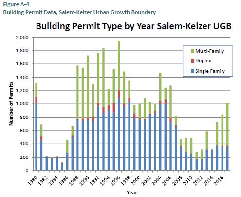 |
| We are still at half of the early 90s levels of permits |
I think that's all I have for the moment on the RTSP. With more time to read individual chapters, maybe there will be more detail to say. If you read it and find anything particularly interesting, please share in a comment!
There will be a Public Hearing on May 28th, and presumably they will adopt it immediately thereafter. But maybe a wave of comment could spur edits.
2021-2026 TIP Applications
I don't think there's anything more beyond these notes from the Technical Advisory Committee at the moment. Maybe there will be more to say later.
 |
| Look for the historic sign next to the entry |
This regular meeting of the SKATS Policy Committee meets Tuesday the 23rd at noon. SKATS is at 100 High St. SE, Suite 200, above Table Five 08.


2 comments:
(Ha ha. Just noticed that the RTSP is a "systems" plan plural, and the City of Salem TSP is a "system" plan singular. I'm not going to go back and fix this, but it's a "systemic" typo throughout this post!)
Yesterday the MPO published a map of ALL the potential projects with an interactive text field that allows for comments on them.
It's a little overwhelming and unwieldy; it will likely solicit comment on pet or neighborhood projects rather than on a holistic sense of priority and purpose.
Still, it's a way to comment.
Maybe over the weekend there will be more to say.
Post a Comment