A query the other day about I-5 and Chemawa from historian SuAnn Reddick suggested the greatest Salem-area disruption from the I-5 system might be at Chemawa.
 |
| New expressway and bypass at Chemawa January 29th, 1953 |
You may recall Reddick from the large package the paper ran in October of 2021 on the Chemawa Indian School, unmarked burials, and its policies and finances.
 |
| October 2021 |
She's been researching the history of Chemawa for a long time.
- See also the database of deaths and burials at Pacific University as well as the archived collection at Willamette University.
She had found this piece that mentions the State Highway Commission approving a route for the Salem Portland Expressway, which "would bisect the Chemawa Indian School Property." Was there more?
 |
| November 25th, 1952 |
On the 24th, the day before, in its story on the Highway Commission's meeting, the evening paper had a little more and suggested the bisection might be contested.
Highway department officials were somewhat concerned over obtaining permission from the U. S. department of Indian affairs to route the new freeway through the school property.
However, these fears were abated with the announcement that Oregon's Governor Douglas McKay would be the new secretary of the interior, under whose jurisdiction the department of Indian affairs operates. There is little doubt that the new interior secretary will grant his approval to the request."
The paper seemed to be silent on the alignment at Chemawa, finding it of little consequence.
 |
| Chemawa in 1947 (Oregon Historical Society) |
But to those at Chemawa Indian School it was a real consequence and disruption, and the routing of the Expressway, which was absorbed a few years later into the Interstate Highway system, likely initiated a large scale shift to the east for campus. From Reddick's Oregon Encyclopedia article on Chemawa:
In the 1970s, $10 million was allotted for a new campus complex and an Indian Health clinic on the east side of the property. As the Salem region grew, Interstate-5 (dedicated in 1966) and local highway expansion reduced the campus to fewer than 300 acres, and the original school buildings were demolished. In 1992, the historic campus—about 79 acres, including the old hospital and cemetery—was placed on the National Register of Historic Places. The last structure on that site, the Chemawa hospital and clinic, had been built in 1907 and burned in 1995. In 2009, a new dormitory for four hundred students was constructed.
The highway may not have demanded any immediate demolition of buildings on campus, though Reddick says, "I think they may have demolished some of the first school buildings," but it was certainly a disruption, intrusive and the start of eroding the historic center of the school and shifting it eastward away from the center on the railroad.
 |
| McMinnville 1924, Mt. Angel 1923, Stayton 1925, Salem 1917 |
The school is nearly at the center of four USGS topo maps, so here's a
composite of the area from four maps c.1920. Again, it is easy to see
how the school buildings cluster around the railroad. A bandstand and gazebo right by the railroad must have marked a center and kind of public square for the campus. If the railroad and its mobility was "sticky" and attracted a campus
center, the interstate was less sticky and its autoism caused the center
to retreat some distance. (We see this today at Keizer Station and the new Costco development: At an interchange, but separated by a short drive.)
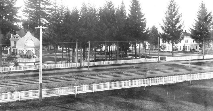 |
| Bandstand/gazebo and railroad (undated, State Library of Oregon) |
Here's a modern aerial zoomed in a bit. The highway alignment did avoid the center of Chemawa, and in the 1953 map at the very top of this post you can see the veer around it.
 |
| Modern aerial |
But an alignment might have connected to the Salem bypass farther north, veering east around Chemawa rather than west. It might be the prior decision on the Salem Bypass alignment rather than the Portland-Salem Expressway alignment that was determinative. (Maybe there will be more to say about this another time.)
 |
| A straight route would really bisect |
For Governor and then Secretary of the Interior McKay, any disruption and reduction at Chemewa might have been more feature than bug. He advocated for "termination" policies locally and then nationally. From the Oregon Encyclopedia:
Of the federal-Indian policies introduced to American Indians, termination of trust relations in the 1950s was arguably the most dangerous for Native peoples. On a case-by-case basis, termination threatened to end the trust relationship the U.S. government had with tribes, bands, communities, and individuals who possessed trust lands or properties, thereby giving Indians the same status as all other American citizens. It meant that they owned land or property without the federal protective responsibilities that were guaranteed them in the 374 United States-Indian treaties that were negotiated and ratified between 1778 and 1871. Termination stripped Indians of their identity, a part of the process to assimilate them into the mainstream American culture.And on McKay:
A fiscal conservative, Governor McKay focused on improving the highway infrastructure in the state and promoted the harvest of old-growth timber so that, through reforestation, Oregon's forestlands could be intensively managed for sustained-yield production. A staunch defender of “free enterprise” and privately owned power companies, McKay successfully battled against the Truman Administration’s proposal for a federally managed Columbia Valley Authority. Criticizing what he saw as obsolete paternalism, the governor also supported termination of the federal government’s trust relationship with Oregon's Klamath Tribe, despite serious questions as to whether the policy would actually prove beneficial to the tribe's members....
Implementing the anti-New Deal Republican Party's war on domestic federal expenditures, Interior Secretary McKay reduced the department’s staffing level by four thousand employees and dramatically slashed its spending. He also personally oversaw the termination of Oregon’s Klamath, Siletz, and Grand Ronde Tribes and their reservations. He promoted Idaho Power Company’s construction of a privately owned hydroelectric dam in Hells Canyon and approved plans to build a dam that would have flooded Utah’s Echo Canyon and Dinosaur National Monument, the outcry over which helped spur the growth of the modern environmental movement.
Beyond the mere fact of reducing acreage for the Expressway, there is weirdness about land ownership.
From "Historical Notes on Chemawa Indian School" in Marion County History, Vol. 5, 1959:
By 1922 the land area of the school had increased to 426 acres. Some of the land was purchased by the students and donated to the school as a token of their gratitude. Most of the money was earned picking hops....
When I have read occasional secondhand reports in the newspaper about hop picking and buying land, any "donation" of picking wages for land purchase has generally seemed rather more compulsory than freely given. "Donation" really seems like a euphemism here. Additionally, there is the original land seizure by settlers, then making indigenous people earn wages to buy back land to give to the government to hold in "trust." Or something like that. It is layered with complications, ambiguity, and irony.
That 1959 piece also doesn't mention relocating campus buildings yet. The Expressway had opened on November 1st, 1955. It's not clear how the intrusion had registered with students and the administration.
The story of relocating campus is complicated, and there are intersecting, even tangled, threads on maintenance budgets and efforts, neglect, and other factors.
 |
| March 11th, 1968 |
 |
| October 8th, 1978 |
The newspaper, which itself didn't necessarily pay close attention to the school, doesn't describe rebuilding or demolition until many years after the highway was completed.
 |
| MOAR HIWAY!!! |
Even now, a plan from a decade ago, the I-5 Chemawa Interchange Area Management Plan, has not seemed too terribly concerned with the cemetery, vestiges of the old campus, and the current school and students. The word "cemetery" appears twice in a document over 100 pages long. It is similarly brief about related matters.
 |
| One of two instances of "cemetery" |
It will be good to read sometime in the future what Reddick finds and how she interprets the disruption from the Expressway and Bypass alignments. Files in the ODOT archives might have more on the State Highway
Commission meeting with material on the assessment of alignment
alternatives, the decisions, and surveying. Maybe there will be records also in Federal archives. On the surface it does not seem likely to be a simple story at all.
See previously on the Salem Bypass and the Expressway to Portland as precursors to the Interstate:


No comments:
Post a Comment