At this point I-5 is just a given. It has always existed. Of course that's not at all true, but only real old-timers will remember a time and the conditions of things before it existed.
 |
| Salem Bypass alignment paralleling Lancaster and outside the city limits (January 13th, 1952) |
The alignment of I-5 in and around Salem turns out to have a layered history.
One part takes us back to an ongoing matter of interest here exactly a century ago.
Baldock the Baddie
Last fall, Portland Tribune wrote,
Robert Hugh "Sam" Baldock, a renowned highway engineer who shaped Oregon's freeway system, was so accomplished that Interstate 5 between Portland and Salem was officially named the Baldock Freeway.
But now Baldock's name is being scrubbed from state transportation facilities because Baldock was a past Ku Klux Klan member.
The Oregon Department of Transportation is moving swiftly to rename those facilities after it was informed by a Portland Tribune reporter of Baldock's Klan membership a century ago.
 |
| May 21st, 1956 |
When Baldock retired in 1956, the encomia mentioned nothing about the Klan, instead highlighting a technical advance in macadamizing roads, a role in pushing for higher design speeds on curves (that "forgiving" design), and the use of drawings in public persuasion.
But there was another side.
Portland Tribune again:
After the Oregon Klan helped Democrat Walter Pierce win a longshot bid for Oregon governor in 1922, the La Grande Klan chapter put forth Baldock's name for promotion when seeking patronage appointments from the new governor...
The La Grande chapter, which dubbed Gov. Pierce an "honorary Klansman," discussed their request for the patronage job at a May 8, 1923, chapter meeting.
"After hearing a splendid report on promoting Klansman Baldock to the position of State Highway Engineer," the minutes state, "this Klan went on record as heartedly favoring this plan to the extent that we begin an active campaign in behalf of Klansman Baldock."
The Baldock Plan
You might recall the post about the "Baldock Plan" for Salem and its concept for a grid of one-way streets and what became the Marion Street Bridge.
The plan was even more of a total scheme for Salem, involving the Capitol Mall and a circumferential bypass on the east side of Salem.
Correlation is not causation, and Baldock might have changed his mind on social arrangements and power, but it is very interesting to note this relation between the traffic plan, its links to exclusionary "sort and separate" zoning, the totalizing impulse in a master plan, and a person who at one time was called "Klansman Baldock."
 |
| Jan. 26th, 1951 |
From the paper in 1951:
Oregon's highway commission has agreed to protect an extended capitol mall in Salem from through highway traffic, it was announced Thursday by commission officials.
The commission decided at a Portland meeting to accept a compromise one-way street plan proposed by the Salem city council....
The change was prompted by the state capitol planning commission which blueprinted an extended capitol mall last year subsequent to the city-state agreement on one-way streets as a feature of the "Baldock plan" for Salem traffic. The latter also includes a Marion street bridge over the Willamette, now in construction, and highway bypasses in north Salem via Pine street and, eventually, east of Salem....
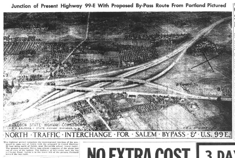
I-5 Adopted Alignment of Salem Bypass
The paper had in 1949 published potential alignments for a Highway 99E bypass east of Salem. They are clear it would be "a circumferential route east of Salem," a way to get highway traffic and congestion out of downtown.
 |
| Candidate alignments January 26th, 1949 |
It was part of a total plan for the Marion Street Bridge and a one-way grid downtown.
 |
| Total traffic plan context January 26th, 1949 |
 |
| To join the Bypass, Expressway, and Portland Road April 10th, 1952 |
Not long after the alignment for the Salem Bypass was settled, it was proposed to link to the Portland Salem Expressway at Portland Road.
 |
| Portland Salem Expressway alignment January 29th, 1953 (click to enlarge) |
The Salem Bypass opened in November of 1954.
 |
| Salem Bypass opens November 2nd, 1954 |
Within a few short years, the Portland Salem Expressway and Salem Bypass were then absorbed into the Interstate Highway System after it was created in 1956, and the two segments were further improved to Interstate standards and named I-5.
 |
| Feb. 2nd, 1952 |
For the Salem Bypass and close-in section of the Portland Salem Expressway, the highways went through sub-urban development outside city limits. The highways did not blast through existing neighborhoods as they had in other places. There's not a lot of discussion in the paper of negotiation, condemnation, or protest. The map of historic tax lot dates the City produced a decade ago shows a few lots on Hawthorne Avenue and Fisher Road from the first half of the 20th century, but no great cluster of them in what looks like a real neighborhood. Maybe more will turn up, and I want to be alert to actual displacement, but at the moment I read this as evidence that the route was going through fields more than through housing.
The maps from 1957 just after completion show housing along Fisher Road and the way Salem proper was butting up against the Interstate, but also showed open field. As the plan was being developed in the decade before, there would have been less of that. Four Corners was the most developed community at that time, and it was not directly affected by the route.
 |
| Salem 1957 and Stayton 1957 USGS maps |
But we know now how much new development occurred east of the bypass. The route and highway has totally lost any identity as a bypass, and we say it goes through Salem.
 |
| This concept may be from 1979 - via Facebook |
When people argue today for a circumferential beltline, as we see at least in part with the current Cordon-Kuebler Corridor Study, it is important to remember any "beltline" never remains a belt with development contained on the inside, and instead induces new development outside of it.
The history of I-5 in Salem is of interest, and there is surely more to say - more to research, and topics to expand on. We'll be returning to this!
See also:
- "Baldock's to Blame! 1949 Traffic Plan Messed up so Many Things" (2022)
- "Why a Beltline Concept for the Bridges was Eliminated" (2018)
- "The Third Bridge's Roots in 1960s I-305 Planning" (2016)
- "1981 Salem Parkway FEIS Omits River Crossing Discussion" (2016)
- At the Oregon Encyclopedia, "Interstate 5 in Oregon"
- At Wikipedia, "Interstate 5 in Oregon."
- And the Albina Vision Trust, focused on a segment of I-5 where it did blast through and completely disrupt a Black neighborhood and commercial district. Baldock's attitudes may be more directly relevant here.


2 comments:
The notation about Earl and Minnie Hitchman caught my eye. They, of course, were the owners of Salem Equipment Company at the corner of Hawthorne and D Street for decades. My father worked there back in the 1970s. Prior to that he worked at A.B. MacLoughlin Manufacturing at Lancaster and D Street (Iocation of the current McDonald's). So, I knew the area well in the 1950s. In addition my uncle lived on Lancaster from 1949 to 1957.
The area between Hawthorne was indeed rural with gravel roads and mostly occupied by orchards and some small farms. I recall my parents talking about the proposed route for I-5. They liked the final location, but did worry about how people would get around the construction. I know that my father dealt with it for years as the freeway was being built. Most people used State Street until that underpass was constructed and then they used Center Street.
Lancaster itself was a two lane country road until well into the 1970s building boom launched by Larry Epping. Much of that area was swampy farmland with the exception of Serra Catholic High School that was built in 1954. I was just talking the other day to my dentist who grew up in that neighborhood in the early 1960s and her family had a farm off of Auburn Road. Four Corners was the main town as you reported with its own Post Office and multiple businesses.
Somewhere I have a set of old colored arial photographs that the City of Salem was throwing away of East Salem. I think they are from about 1970. I should dig them out!
Thanks for the additional detail and local lore!
Post a Comment