Has the City made some definite progress on the mystery of the Asylum Cemetery?
 |
| Project location, with site context notes added |
At Council on Monday there is a set of "amendments to the purchase and sale agreements between the City and Salem Health and between the City and Green Light-Home First, LLC for the sale of the former Salem General Hospital site."
In addition to using bond funds temporarily on a pass-through for the sale, the amendments "allow the City to retain ownership of a 50,000 square foot Conservation Area and develop a park/memorial on the site within the 10-acre property."
Ordinarily the Staff Report would include a separate map of the "conservation area," but it is kept a little inconspicuous on the general site plan included as an attachment to the Staff Report. There it is identified as "archeological preservation area."
 |
| Conservation area (yellow added) |
Sometimes the exact location of sensitive archeological sites are not disclosed publicly, and downplaying it might be in play here. But information on the area is in fact in the Staff Report packet. It had been part of a second phase for the housing project.
There are possibilities other than the Asylum Cemetery, too. Its significance could be a just a parcel abutting the Jason Lee Cemetery; maybe there's a seasonal waterway or something in there also. There are possibly future trees as in parkland highlighted on the site plan map. Maybe there are other people not previously buried there to remember. It's not necessarily anything related to the Asylum Cemetery. But the language of "park/memorial" is suggestive. Earlier research had suggested any burials might be west of 23rd rather than east of it as had been supposed.
This will be interesting to learn more about. (Update: See below for more.)
Previously:
- "Mystery of the Asylum Cemetery Continues" (2019)
- "City Council, December 4th - Redeveloping the old General Hospital Site" (2023)
- "Gussie Belle Brown Apartments at Former General Hospital Site in for Site Plan Review" (June)
- And on an existing memorial, the Columbarium at the State Hospital, "Alterations for Cremains Memorial Bridge Past and Future" (2014) and "Cremains Memorial called "Elegant Masterpiece" by Seattle AIA Jurors" (2014).
 |
| 26 Townhouses approved on Brush College Road |
There's an information item on a set of Townhouses approved for a parcel next to Brush College Elementary School.
 |
| Project site: A pocket of MU-I zoning (purple) |
It is another instance of a single use going in on mixed-use zoned property.
Apparently an earlier proposal for it had three-story buildings with around 60 homes. As neighbors criticized it for "too many units and high density" and on "neighborhood character," it was scaled back to middle housing forms, a set of 26 townhouses.
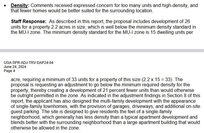 |
| On density |
 |
| More on density |
 |
| On neighborhood character |
With the looping drive, it's not a very urban townhouse configuration, and 2/3 of them won't actually face any real street.
The project had to win a reduction in the minimum ratio of homes/acre, from 15 to 12. (Remember, walkable urbanism starts happening at between 10 to 20 homes/acre!)
But with housing only there's no second use in the project. So it's not clear how effective was the MU-I zoning.
 |
| On parking |
The units will have garages and a few guest parking spaces.
The project will also build an 8-foot sidewalk, wider than the minimum of 5-foot, and 7-foot shoulder, a quasi bike lane, on Brush College Road.
All in all it's a decent project as middle housing, but not quite mixed-use housing. And even though the middle housing form is "walkable," there aren't walkable commercial destinations nearby, only the school and park. The new food cart pod, Checkpoint 221, is one mile away, just on the edge of any "20-minute" neighborhood concept. This new housing will remain essentially car-dependent.
 |
| 183 Apartments on Joseph St SE |
There's a
proposal to use $3 million in bond money for offsite "water, sewer,
street, and stormwater" to support an affordable housing project with
183 homes way out by the former Tuberculosis Hospital site (later Western Baptist and Corban College).
It's utterly car-dependent out there, but maybe it would be housing for some of the warehouse employees in the new industrial district southeast of Kuebler/Cordon.
Finally, there's a set of code amendments to support housing production, including compliance with new State rules and regulation, as well as a few other adjustments.
Two neighborhoods offered some criticism of details in new mixed-use zoning, and the City's general response is that it's too early to start making changes and there will be better processes in a year or two for more seriously contemplating them.
The City has just started to see developments being proposed in the MU-I and MU-II zones, and as more projects are proposed, the City may evaluate if any standards in the mixed-use zones are consistent barriers to development and therefore should be revised.
Significantly, neither the Historic Landmarks Commission nor Planning Commission had any criticism and both recommended approval of the whole set of changes. SCAN had some reservations about some historic approvals shifting from a full Public Hearing at the HLC to an administrative process, but the HLC did not seem to share the reservations. On the whole the amendments seem reasonable.
And some bullets:
- Councilor Stapleton is resigning as Council President, but looks to finish out her term as Councilor.
- At both Council and the Urban Renewal Agency, Mayor Hoy proposes better disclosure and transparency on projects receiving City grants and tax abatements.
Addendum, July 21st
In supplemental materials for last month's Bond Committee meeting, a slide identifies the "conservation area" not as any vestigial Asylum Cemetery site, but as a cemetery for General Hospital. A Potter's Field for the old hospital would be a whole new can of worms, and it will be very interesting, and very possibly also upsetting, to learn more about that.
 |
| From last month's Bond Committee meeting |
In the neighborhood update earlier this month, Salem Reporter featured a Sequoia that the neighborhood association lobbied to preserve. It's not clear how recent is that result, if this represents a change in the last month or so, or if this was already part of the plan from the spring and winter.
 |
| Sequoia to be conserved |
Here is the area in question.
 |
| Sequoia and new mystery burial ground |


1 comment:
Updated with slide from June Bond Committee meeting, which says General Hospital burial ground, not Asylum Cemetery.
Post a Comment