The City's "Walk to a Park" campaign last week didn't seem to generate much comment on social media. The way they promoted it is weird, and a walk around the perimeter of the Fairview project illustrated the problems.
 |
| via FB |
The City published a list of "Walkable Neighborhood Parks."
About it they said:
Salem has 93 parks, most of them neighborhood parks! In honor of this day, we've created a series of maps showing the parks available in each Salem Neighborhood so that you can walk to a park near you today! Download your favorites and take them with you on your mobile device to explore Salem parks near you.
It's just a data dump! They show all of the areas designated for "parks," including future parks, and it was unvetted by a human who might actually walk to each park area and verify that it is indeed walkable and indeed developed as a park.
 |
| This is a lot of nonsense! |
The "parks" on the perimeter of the Fairview redevelopment, Braden Lane Natural Area, Reed Road Park, and Fairview Park, are all undeveloped. Fairview Park at least has some very minor signage, and might slip in on a technicality as a real park, but Braden Lane and Reed Road are not anything you'd walk to and should not count as a park. They are unsigned, lack any access from the primary roads that border them, and look more like "no trespassing" situations.
The maps lack legends also. The dark green must be improved parks, the hatched line must mean future parks, and the lighter green some kind of "walkshed." But you have to decode this! If the City wants these to be usable, they should delete the unimproved park areas and provide a legend.
They also need to add a sidewalk layer and auto speed layer. Assessing walkability without these is useless.
 |
| 2020 Sidewalk inventory (SKATS) |
Reed Road Park is the most forbidding.
Walking south-ish on Battle Creek there is no sidewalk. When the sidewalks starts up again, at Southhampton the sidewalk is totally overgrown with brush and bramble.
 |
| Sidewalk hidden and totally overgrown Reed Road "Park" in background |
After walking in the bike lane, with cars zooming by at 40mph and more, you reach Reed Road and might cross into the "park," but it's totally overgrown, and there's no park signage.
 |
| Reed Road "Park" |
Reed Road here is signed for 45mph and there are no sidewalks.
 |
| No sidewalk and 45mph |
Not only is there no park, it's not walkable by any reasonable definition. I mean, it's possible to walk, but you have to walk directly in the street, as there aren't even bike lanes on this part of Reed Road. As a destination and part of a City campaign to "walk to a park" it's total nonsense.
Occasionally people have posted on social media notes on walks in the Braden Lane Natural Area, but they probably access it from inside Fairview Addition, and any good access counts as hyper-local neighborhood private lore, and not anything public. From Pringle Road and Battle Creek Road it is essentially inaccessible. There are no sidewalks on its side of the street, and no crosswalks south of Leslie Middle School. It is not "walkable" from any exterior, adjoining neighborhood.
When sidewalks, signage, and interior paths are finally put in so it counts as some kind of actual park a person might walk to, a natural history of the area ought to be considered.
A friend of the blog very recently pointed out a great new resource. In the past year OSU has digitized a bunch of aerial maps including a set from 1936 made for the US Department of Agriculture. (Unfortunately it's not complete, and the downtown area is missing.)
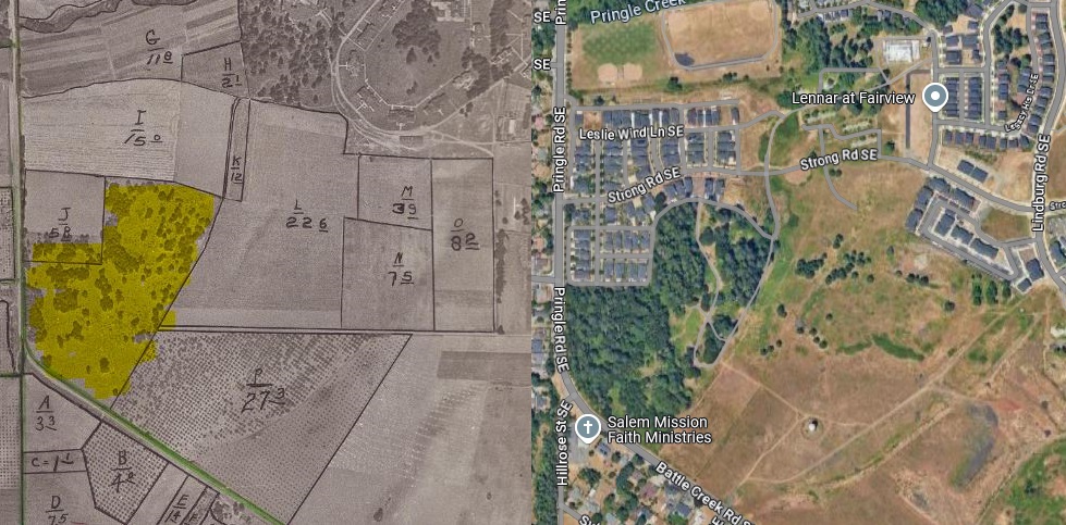 |
| Braden Lane Natural Area in 1936 and current |
You can see how sparse was the tree coverage in 1936! Today there are Oaks and Douglas Fir and other things, but there must have been succession growth. Did the 1936 image show something closer to a remnant Oak Savannah? Or was it even second growth planting by settlers? This natural history should be discussed more! Can we know from it anything about Kalapuyan management of the Oak Savannah? About the settlers interventions? Then the State Institution? There are layers here, and maybe the future park can furnish evidence and interpretative signage or other display.
At the last Parks & Recreation Advisory Board meeting they saw the new, revised Fairview Park Master Plan.
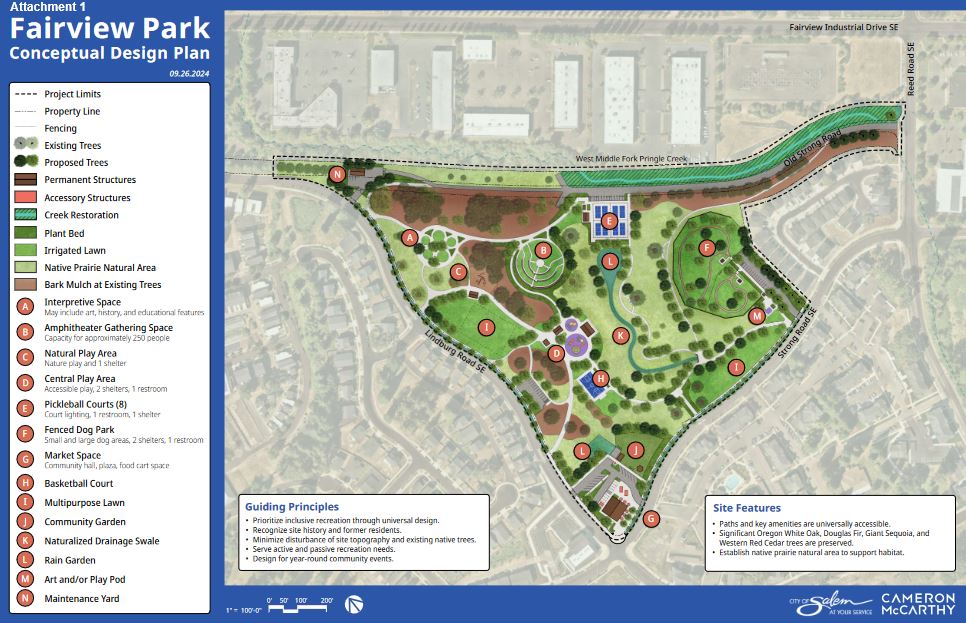 |
| Revised Master Plan Sept. 2024 |
They deleted the sports fields, and shifted the focus to more passive kinds of recreation with more paths and open space.
In it is a concept for the plaza area at the crossroads and old Village Center. This area was not in the original planned park area, so this is wholly new rather than revision.
 |
| Proposed Plaza with food carts and market at G (key to panorama below added) |
The concept is for a market building, food cart pot, and small plaza area. But you can see the parking lot, too.
Across the street is the new church building.
 |
| Intersection of Strong and Lindburg Roads Church on left, park area on right |
We've already remarked on the abandonment of the Village Center, and a food cart pod, church, and forthcoming convenience store on a third corner is just such a slack, low energy kind of development for this key crossroad.
 |
| Just off Lindburg Road |
At least on Lindburg Road there was a path and a kiosk, so it is plausible to say even as an undeveloped park it counts as a park a person could walk to. The new development in Fairview has good sidewalks! There were more people out walking than in most Salem neighborhoods. But again, from older, adjacent neighborhoods, the walking is frequently very dicey.
As this walk around the Fairview perimeter shows, the City map for parks in the Morningside area is not reliable. How unreliable are the maps for other areas? The execution on Walk to a Park Day support materials was flawed, and exemplifies the ways the City talks nice, but does not always walk the talk.
In a second post there will be more to say about walking inside of Fairview and along the new developments.


No comments:
Post a Comment