Over at Salem Reporter there's a tantalizing story about Salmon Brown's house across the street from the downtown Safeway.
 |
| This identification is doubtful - note the sidewalk |
But there is reason to doubt the identification and reason to doubt that the house is still standing.
The photo in the Salem Reporter article is taken from Marion Street looking north.
 |
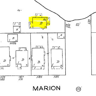
| Recessed from Marion St. sidewalk (1895 Sanborn map, LOC) |
On the 1895 Sanborn map, the relevant houses are recessed a ways from Marion Street and sidewalk. The photos taken from the top of the school, as well as those taken from the ground, also show houses recessed from the sidewalk.
 |
| How to get this into a four-square? (1965) (Salem Library Historic Photos) |
The windows and basic footprint of each house don't align very well. On the later four-square the windows are also old enough to be original, and do not correspond at all with the window openings in the earlier gabled house. The plate of the older house is also a rectangle with a bay window, and the current house has a square plate.
 |
| On the 1926 Sanborn map, houses hug the sidewalk |
By 1926, there is a row of houses right on Marion Street, and the disposition of the two earlier houses on the 1895 map, much nearer the creek, are not easy to line up if at all.
Though the Assessor lists the current house as constructed in 1890, that may be the date of the lot rather than house. In our "Houses of Grant Neighborhood" the foursquare style is dated "1890-1915," but the examples are all from the 20th century, 1905 and later. It would be strange for an old house to be remodeled into a four-square after 1965. The current house in the photo instead likely dates from the early 20th century, consistent with the examples in the Grant neighborhood, and consistent with the 1926 Sanborn map.
Altogether, identifying the current house that is pictured in the photo with the earlier farm house of Salmon Brown is at best very difficult, and more likely just not true.
 |
| But the house on 13th might be right |
Instead, on the 1926 map the Salmon Brown house is likely the one facing the stub of 13th Street (yellow highlight). Note the location of the bay window on the south side just around the corner from the front porch.
Here's the view from 13th today, looking west from the dead-end of 13th. (The four-square is in the back on the left.)
 |
| It's an ODOT parking lot today |
It is at least theoretically that the Salmon Brown house was moved and remodeled after the 1965 photo, but this seems so very unlikely, and historians who claim the house is standing would need to argue for this with evidence, not simply assert it.
But if so, it would have been a second move. Based on evidence from the Sanborn maps, the house may have moved once already, moving approximately to the site of the old barn and fronting 13th at the creek.
 |
| 1895 Sanborn detail with 1926 inset |
From the site on 13th, whether there was one move or two, it would be easy for the Capitol columns to be just rolled into the creek - you can see some of them still from the footbridge! Not all were recovered from the creek and placed at the Capitol.
The history of Salmon Brown is of real interest, but we should be more careful in our history of him.
 |
| Teasing a long series |
Unfortunately, earlier pieces do not shed much light on any move of the house.
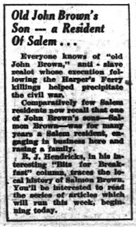
- In the morning paper, the Bitsman ran a long series, mostly on John Brown, in 1931 (front page tease just above). November 10th, November 11th, November 12, November 13th, November 14th, November 15th, November 17th, November 18th, December 6th.
- He returned to the topic in 1937, and the adjoining cartoon is particularly interesting.
Then Ben Maxwell ran a photo comparison in 1949, part of his work documenting things before the school, which Safeway replaced, was demolished.
 |
| December 13th, 1949 |
He did mention a house move, though the second photo after microfilming and digitizing is very difficult to read. And the mass of the house on the left in the early photo does not seem to appear between the trees on the later photo. It's hard to be very definite with any interpretation of it, however.
In the immediate foreground facing Marion street, and flanked by a wooden fence, is an old dwelling that then stood near the center of the block. Some decades ago this structure was moved and in the recent view stands to the right and behind more modern houses.
Facing 13th Street might be more accurate than "facing Marion street," but with the image quality it is hard to say. At any rate, this appears to reflect a move.
I think we need information on the construction of the ODOT building and parking lot. Perhaps the newspapers after 1965 have some notes about the house.
All in all, identifying the four-square with the single-gable house Salmon Brown lived in seems premature and doubtful, almost certainly a case of historical romance and wishful thinking.
Elsewhere, more recently:
- At Capital Taps, which may be an unacknowledged source for these pieces, "John Brown's Son and the Capitol Fire: Chance Encounters on Mill Creek" (2012)
- At the Mill, "John Brown’s Baby lived in Salem" (2016)


3 comments:
(Edit: Revised the comments on the 1949 Ben Maxwell piece, which does after all refer to a move of the house!)
A couple more things with a little more time...
The captions in the the Library's Historic Photo Collection locate the house on 13th rather than on Marion, though naming the corner might be a little ambiguous, since at neither site on the block it's actually on the corner. But the four-square at 1243 Marion is mid-block, not at all on the corner or on 13th.
"The house is at the north end of 13th Street by Mill Creek."
"The location is 13th Street N. and Marion Street."
"The location is 13th Street N. and Marion Street."
The last one of them is a Cronise copy likely made in 1920, but the mark on the print is frequently misinterpreted as the date the image was made.
The image is certainly from the 19th century, but the print made in 1920. It could be a copy negative also. Development in Salem was much greater in 1920 than what this image shows. Consider the density of development just 6 years later on the 1926 Sanborn map.
In the Library's collection there are other images marked as I read it "COPR 1920 TG" that also strongly look later than 1920. The best hypothesis is that from a batch of older negatives, either created by Cronise or acquired by the Cronise studio, the studio made a bunch of copy negatives or copy positives in 1920, which they imprinted with the year, perhaps for a copyright claim. (Here is a different photo captioned with what I believe is the correct interpretation.)
And a few more notes on the 1949 article and photos of Ben Maxwell.
Post a Comment