Friday, October 31, 2014

City Contest: Creative Opportunity - or, Flood the City with Howard Hall!

From a public relations standpoint, the timing of the photo contest sponsored by the Historic Landmarks Commission and just announced is a little interesting. With a highly contested demolition permit in the works, it's a little like one of those hashtag promotions that could go awry.

Howard Hall should matter more
But either way, it's an excellent opportunity to remind the City and the Hospital that our historic buildings matter.

Like Howard Hall, for example!

From the blurb in the Fall HLC newsletter:

Thursday, October 30, 2014

The New Deal in Salem Still has a Meaningful Legacy

It was interesting to see a headline about the end of a stimulus campaign. (It's still odd to read the paper and see a bunch of USA Today branded stuff.)

The stock market might be up - though it's had some turbulence of late - but the job market and the economy as it affects real people still doesn't seem so great. Lousy, in fact.


So has that stimulus really made so much of a difference? At the least, "quantitative easing" is too hidden, too much an obscure mystery only the true adepts can grasp.

So now's maybe a good time to revisit the New Deal, and lucky for us, there are many tangible - literally concrete! - things from it that are still with us and are easy to grasp.

Two images from the design competition
(75th anniversary site)
Berkeley has a funny, probably somewhat neglected website called the "Living New Deal." It lists projects in Salem funded by the New Deal:
To this list we could add:
And reader additions:
 Do you know of other buildings or infrastructure funded by New Deal programs?*

Wednesday, October 29, 2014

The New Bark Mulch Setback and the Old High Street Bypass

Things are a little slow at the moment, and there seems to be less of immediate interest to talk about or comment on. Here's a couple of odd - and a little spleeny - bits that don't really fit into any larger discussion right now.

The High Street Bypass

One thing that has been of a long but slow interest is the way we treat High Street just south of downtown.

High Street Bypass says it's for "local traffic only"
How many people register the sign at the intersection of Mission and High?

Local traffic only - Through traffic use Commercial Street.

If they do register it, it is routinely ignored. In the afternoon, High Street sees a steady stream of drivers using it as a bypass out of downtown. They turn at Rural or Hoyt, using the light there as a way to get back onto Commercial going south.

The problem of through-traffic is acute enough that on the crest of Fry Hill, where the sightlines are reduced, both crosswalks are closed and auto traffic given full priority. Kids, too, sometimes drive too fast there in order to hop the crest and catch some air.

Sidewalks closed on High and Oak by Library
The six lanes of the Liberty/Commercial couplet are just one block away, however, so there is no need for a parallel throughway, and yet we also treat High Street as a throughway here.

One of the things that came out of Bike and Walk Salem is that people on bike prefer a Church Street alignment for north-south travel. So this is not an urgent problem. But if we took literally the "local traffic only" for High Street, we could install one or more traffic diverters or other traffic calming in between Mission and Rural, as well as open the crosswalks on High and Oak, and really make High Street a pleasant byway and adjunct to the park for walking and biking

Why isn't non-auto traffic prioritized here?

Bark Mulch Setbacks

Why???

Bark landscaping and doorless faces make this a Potemkin Village!
I think this is in the County, not City, Off Munkers

Tuesday, October 28, 2014

Cranksgiving is Back, November 22nd

After a three-year hiatus, the Cranksgiving alleycat is back!

Built at the end of the Streetcar Era:
Home of Northwest Hub and Evergreen Presbyterian
Its organizers have been working on the Northwest Hub, and before that were away from Salem. We weren't sure if it would ever be back.

A restorative draught after
the 2010 Cranksgiving
Worry no more! A few days ago they announced the alleycat would return for a second run after its 2010 debut.

Items will be donated to Marion-Polk Food Share:
[P]articipants are given a shopping list of 10 food and household items to be purchased from 10 different locations. The locations aren't predetermined, buy them where you can find them and then return to the start once you've completed your shopping. Keep all receipts, they will be required to prove you followed the rules. The first to return "wins". It's an urban scramble meant to be fun and noncompetitive. All participants will participate solo, unless paired on a tandem bicycle, which of course we'll allow. Bring your bike, a bag, helmet, lock and cash/card. The shopping should cost no more than $20 if you're thrifty. If you're in a hurry it could cost you more. All items will go to the Marion-Polk Food Share.
The event commences at 10am on Saturday, November 22nd, at the Broadway Coffeehouse.

Broadway Commons: Also Streetcar Scaled
It was great also to see the smoothie blender bikes at the Urban Agfest earlier this month had been built by Hub!

Sunday, October 26, 2014

City Council, October 27th - Work Sessions

Maybe the most interesting items on the Council agenda for Monday aren't actually on the agenda itself. Before the meeting is a Council work session on transit, and for the week after they've announced another one for the Third Bridge.

We need to talk more about the ways
transit and the bridge are related
in the total mobility equation

Work sessions

Joint Work Session with Salem Keizer Transit ~ Monday, Council Chambers, 5:30 p.m.

Discussion of Oversight Committee’s Third River Crossing ~ Monday, November 3, 5:30 p.m.

The matters will be kept separate for the moment, but maybe at some point they will cross and start to be more integrated as we talk about increasing human capacity in mobility instead of treating mobility as solely hydraulic autoism. In any case, maybe the third bridge session will have more realism about funding and about seismic retrofits. Maybe. Hopefully.

However!

Buried in an update on Council Goals is this spin on the failed TGM grant application for the bridghead districts:
The City applied for funds through the Transportation and Growth Management Program to undertake refinement planning in the vicinity of the bridgeheads. While this request did not receive funding in the 2014 round, a future request should be more competitive as the region moves forward with the required land use approvals for the preferred alternative. Furthermore, the need for this refinement planning will likelv be included as a mitigation action in the Final EIS.
Is this just completely delusional, or does the City know something about the land use approvals that we do not?

Other Items

A couple of fee related things

The bulk of public comment is associated with the proposed new fee schedule for "utility service rates (water, wastewater, and stormwater)." One person writes: "You are raising water costs to the point where people will stop watering their plants/lawns. "

Thursday, October 23, 2014

Fairview West Addition Looks Pretty Good

In my bikey Utopian fantasy, there might be things to criticize in the Refinement Plan proposed for the Eric Olsen development at Fairview.

Seriously, can new construction be any more adorable?
Edwards Addition, Monmouth
Eric Olsen Development
But since we live in Salem, it's difficult to find fault with the plan. It will be very interesting to learn if representatives from Pringle Creek Community, Sustainable Fairview Associates, Simpson Hills, or the Morningside Neighborhood Association find much substantive to critique. There are a number of technical details on the way the jigsaw puzzle fits together at the seams between different developments, and these seem like the most likely place for revisions.

Overall, though, from here it looks like a realistically optimistic and progressive plan that yet doesn't get too far out on front of the actual market in Salem. It's hard to see a reason this wouldn't speed through the approvals process. (Do you see something?)

Wednesday, October 22, 2014

DAB Looks to end Downtown Parking Garage Subsidy; EOA-HNA Draft Reports Out

Tomorrow in the municipal acronymic pile-up, DAB and EOA-HNA meet!

(click to enlarge)

(click to enlarge)
You can't really see them at this size, but clips from the September minutes of the Downtown Advisory Board have some interesting tidbits:
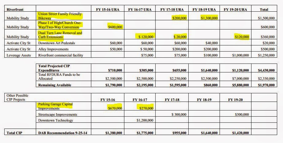
  • Starting in 2017-18 the Board recommends that there be no more subsidy for capital expenses on the parking garages downtown. The subsidy will taper, and the allocation for 2016-17 will be less than half of the usual amount. This is likely to hasten a longer-term solution to the problem of funding downtown parking.
  • In addition to the light and other improvements at Union and Commercial, the DAB is recommending work, principally striping bike lanes, on the High/Church couplet  as well as eliminating several sets of dual-turn lanes. (Though the notes say "Union Street Family-Friendly Bikeway" and "High/Church One-Way/Two-Way Conversion" both labels are a bit misleading. The preliminary steps would involve paint and striping only, and still leave the real family-friendly and two-way conversions for later. See here for more on the Union Street details.)
  • There's also a cryptic allocation for a "Riverfront commercial facility." It's from the Downtown Strategic Action Plan and is still more general concept than detailed proposal or plan.
Here's the "short-term" chart from the final and adopted mobility study recommendations. With this funding plan, more than half of the "short-term" recommendations would be funded, leaving only work on Winter and Cottage Streets.

Tuesday, October 21, 2014

Is Alternative 2A really that much better than the Salem Alternative/4D?

Over at N3B, advocates are talking up Alternative 2A, which widens the existing Center and Marion Street Bridges, as a "compromise."

Alternative 2A, widening the existing bridges, from the air
from Task Force presentation, April 2012
The one clear advantage of it, is that if adopted, it would be easier to modify or dial-back in ten or twenty years as conditions change. It is much more revocable than the others!

But is it truly better?

Here are some of the real trade-offs for people who are not driving cars.

from Chapter 2 of Draft Environmental Impact Statement
(comments in black added)
Maybe the biggest one is the loss of the path along the Center Street Bridge. This would shunt all people who are walking and biking across the river to the Union Street Railroad Bridge. If you are coming from Edgewater, or if you are a speedy, confident cyclist, this removes the most direct route and imposes a good bit of out-of-direction travel.

The out-of-direction travel is even more aggravating for people on foot, for whom the deflections add several additional "block equivalents" to travel time.

Monday, October 20, 2014

Oregon Supreme Court; CAN-DO on Liberty and Broadway - Bits

In a nice appreciation today of the Oregon Supreme Court, Hannah Hoffman describes it as like "watching the ballet."

The building, too, is quite handsome, and it's 100 years old this year.

As the weather has so completely turned around from yesterday's glory, it's a reason to console yourself and take a moment to appreciate one of our most important institutions!

Supreme Court Building today
Its designer, William C. Knighton, is responsible for
several of Salem's loveliest buildings

Saturday, October 18, 2014

The Costs of Autoism: 2.5 Million trips to the ER and $18 Billion each Year

Maybe you will say that it was a slow news day, but it is interesting to note that of the first three pages in the paper this morning, two are devoted nearly full page to the tragic aftermath of automobile crashes.

Page three on survivors

Front page on one who perished
It's more than 30,000 dead each year. The Center for Disease Control says,
More than 2.5 million people went to the emergency department (ED) – and nearly 200,000 of them were hospitalized – because of motor vehicle crash injuries in 2012, according to the latest Vital Signs report by the Centers for Disease Control and Prevention.

Lifetime medical costs for these crash injuries totaled $18 billion. This includes approximately $8 billion for those who were treated in the ED and released and $10 billion for those who were hospitalized. Lifetime work lost because of 2012 crash injuries cost an estimated $33 billion.

“In 2012, nearly 7,000 people went to the emergency department every day due to car crash injuries,” said CDC Principal Deputy Director Ileana Arias, Ph.D. “Motor vehicle crash injuries occur all too frequently and have health and economic costs for individuals, the health care system, and society. We need to do more to keep people safe and reduce crash injuries and medical costs.”
For each person who dies, eight are hospitalized
and 100 go to the ER
On top of $18 billion in medical care, that's $33 billion in lost wages. That's a lot of productivity, too, sucked out of our economy.

If something is dangerous and costly, rather than trying to do the same amount of it but a little safer, maybe a better approach to risk management is to do less of it.

Making it easy for people to choose not to drive should be at the center of the ways we make driving safer for those times when using a motor vehicle is truly the best transportation choice.

Thursday, October 16, 2014

Hearing Date Set for Fairview Refinement Plan of Eric Olsen Development

Eric Olsen development on Rural Street South
You may remember in 2012 the debate over the third Fairview Refinement Plan for the Simpson Hills property. It took a while and many were not satisfied by the final outcome.

A Public Hearing has been set for the first pass at a fourth Refinement Plan, that of Eric Olsen's development just south of Leslie Middle School, and on the surface it looks a lot more sensitive to the Master Plan than the Simpson Hills plan ever was.

The City has set up a project site here, and there are several documents to review.  Here's the concept site plan. Note the alleys for car access and storage in the backs of houses.

Concept Plan for the development
This is by design of course. Olsen's website blurbs "The Front Porch is Back," and the development on Rural by the cemetery and the development in Monmouth both put the porch rather than the garage front-and-center.

Wednesday, October 15, 2014

Super-Sized Wallace and Glen Creek Remains Charlie Foxtrot for Many

Is there any point to talking about Wallace and Glen Creek again?

But the autoist propaganda machine is at it again! So it seems like it's necessary to rant point out that there's a lot of cost to the intersection engorgement.

While the existence of crosswalks - indeed an increase from three to four crosswalks -  sounds like it might be an improvement, because of the massive widening, the intersection will be more forbidding than ever before to travelers on bike and on foot.

On a map it looks like it might be easier to cross, but in reality the crossings will be longer, there will be more lanes of streaming car traffic to contend with or evade, and it will be more stressful, not less. Hale and hearty 20-year-olds might not find it difficult, but those at the ends of the 8 to 80 spectrum will certainly do so. How many parents would send their kids alone across the intersection? How many would want their own parents walking across it?

It's also clear the "improvements" are fundamentally hydraulic autoism, all about flow and pumping more cars through the intersection. (We might, for example, have spent $10 million on alternatives to drive-alone trips, thereby reducing traffic rather than accommodating it and inducing even more traffic and congestion in road widening.)
Once the lights are turned on the traffic lanes are opened, drivers will have some major changes to contend with. The new configuration will provide dual left-turn lanes from northbound Wallace to westbound Glen Creek, in addition to dual right-turn lanes from eastbound Glen Creek to southbound Wallace. There also will be two dedicated left turn lanes, rather than one, from westbound Glen Creek onto southbound Wallace Road.

“What we hope to accomplish is getting more of those cars off of Wallace during the evening peak hours, and in the morning peak hours getting more cars off of Glen Creek onto Wallace,” [Project Manager] Kimsey said.
The crosswalks and necessary traffic light timing for them all constitute "pedestrian impedance," delays and clogs in the ideal world of free-flow and autoist trafficky goodness. 

Here again are the plans from 2011 with an inset of the now-former conditions:

This is from 2011 and may not represent the final, built design
click to enlarge and see notes
Maybe on a sunny day it after the traffic wands and barrels are gone it will be possible to take a picture from the west, uphill side that will show adequately the vastness of the intersection. It's an urban highway, not some pedestrian-friendly byway!

On Glen Creek looking west, up the hill
Postscript

Here's a second thought: How much Cherriots service, calculated from the current "inefficient" configuration, would $10 million buy? Is that months of service, years of service, decades of service? How far would $10 million go just in West Salem?

It is convenient, but not very truthful, to treat the system reboot
and the Third Bridge as wholly separate matters
This is hypothetical, because the funding sources are entirely different, but that might be the best way to think about the opportunity cost of super-sizing the intersection here.

Also, previous notes on this project, going back to 2009, are collected here.

January 11th, 2015

Here's some praise.

No people, no cars, no life
via Moving Salem Forward
There are no people, no cars, no life. I'm just not seeing "WOW" or "transforming investment" or "positive change" or "livability." This is just sloganeering as empty as the intersection. Has the writer actually walked or bike through the intersection? I suspect the photo is taken from a car window, though it is possible that traffic was light enough they walked into the road. At any rate it is taken from a car lane, and represents the perspective of a driver, not a different user of the road.

Anyway, it's good to read the other side...

Update, April 2015

Would you send your child to the park on this by bike?
Note two people on bike in the crosswalk!
(Looking down Glen Creek towards Wallace Park)

Tuesday, October 14, 2014

Oregonian Pulls Thatcher Endorsement for Senate Over Road Construction Mess

Late yesterday, after State Representative Kim Thatcher's campaign for State Senate collided with some road construction problems over the weekend, The Oregonian changed course and withdrew its endorsement.

The Statesman picked up the story off the wire
This wouldn't be news here, but Thatcher's business is in fact a road construction firm, and contracts with ODOT appear to be part of the mess and reason for the de-endorsement.

From the weekend's piece:
Newly disclosed state records show state Rep. Kim Thatcher's closely held construction company destroyed evidence and engaged in a cover-up to fend off efforts four years ago to investigate allegations of state contracting fraud.

A state judge hit KT Contracting Company Inc. with a $60,000 sanction in 2010 for its deceit. Two company officials -- Thatcher's husband, Karl, and their nephew -- repeatedly asserted Fifth Amendment rights against self-incrimination when questioned under oath about the evidence destruction....
The Statesman then picked up the news story off the wire (clip at top).

The Oregonian's Editorial side hadn't been aware of the story, and decided the news was big enough they needed to revise editorial positions.

Also perhaps of note: Thatcher's opponent apparently bikes, or at least has courted people who bike in Portland.
(Since there's no substantive transportation policy matter here and this blog is not meant as a place to talk about why one person is a better candidate than the other, comments are turned off.)

Monday, October 13, 2014

A Forgotten Master of Brick? Lyle Bartholomew's Buildings Stand Up

While it has not been difficult to find out a little about the planning and design of Parrish Middle and North Salem High Schools, the planning and design of the old Leslie Junior High has been a minor mystery.

But it turns out that its designer has a meaningful body of work in town.

Salvation Army (Update: 1938)
via City of Salem Walking Tour
(attribution tentative)

Old West Salem City Hall, 1936
via Waymarking

Leslie Junior High School, 1937 (Update: 1927-1937)

Saturday, October 11, 2014

City Council, October 13th

On Council agenda for Monday is very little of direct interest here. There's a couple of second reading of ordinances that have already been discussed, that sort of thing.

So this will meander more than a little.

One of those matters is the first reading of the ordinance to vacate remnant alleys and streets at the Blind School. So let's talk about that in an indirect way.

Last month the Hospital trumpeted its new Cancer Institute.

Shiny!

But the Hospital was conspicuously absent in press or public conversation about James Sallis' talk, "Rx for Better Health."

(click to enlarge)
Maybe this shouldn't surprise us given their commitment to drive-alone trips and car storage.

A huge proportion of the hospital campus is devoted to parking
The bias for treatment over prevention - does this qualify, maybe, as a bit of rent-seeking? - is a huge structural problem in the way we deliver health care. Cancer treatment is far more lucrative and prestigious than promoting basic activities like walking that retard rates of cancer.

As long as you have ill people, we have services to sell!

Thursday, October 9, 2014

Riverfront Park Bike Repair Station is Open! Other Good News and Bad News

Getting ready to pump up a tire
There's a workstand with tools and a tire pump.

It's located right by the spash pad and dock, hopefully with enough visibility that vandalism won't be a problem - though it's also a little off the way for more serious recreational riders who might not find it from the Willamette Valley Scenic Bikeway. 

Earlier in the summer:
Fresh concrete for bike repair station at Riverfront Park
If it's successful, maybe more can be installed around town.

In any case it will serve those in Riverfront and Wallace Parks well.

More Good News

(This has nothing to do with bikes!)
Ok, so the burst water pipe and subsequent flooding is not good news. But the recovery appears to offer Wild Pear an opportunity to enhance the restoration of the 1880 Adolph Bock.

They talk about taking out the tin ceiling, numbering each panel, and then restoring it in order and say
We are committed to doing everything it takes to restore it to its historic standards, and make it as good, if not better, than it was before
I mean, they're embracing the preservation role with relish!

That's a cheery thought.

Wednesday, October 8, 2014

Chemeketa Bikeway's Future? Also, new Firehouse Crossing Shopping Center and its Sidewalk

The crash a couple of days ago between a car and moped at Chemeketa and High brought to mind the proposed development for the old City Hall site.

Revived concept for Old City Hall site: High & Chemeketa,
which would have included the Belluschi Bank lot (far right)
via Skyscraperpage.com
This is an old rendering, and it may have been - or may will be - superseded. Still, it's a pretty big midrise project by Salem standards.

It also went through approvals and traffic analysis before Bike and Walk Salem was adopted into the Transportation System Plan. So it does not necessarily accommodate the fact that Chemeketa is a designated bikeway. Similarly, it precedes the the Downtown Mobility Study and was conceptualized before there were plans to reconfigure High Street.

So what happens to the streets when this thing gets built?

(See here for the extension on the demolition permit and the site plan approval.)

CB|Two Continues to Experiment with More Walkable Designs

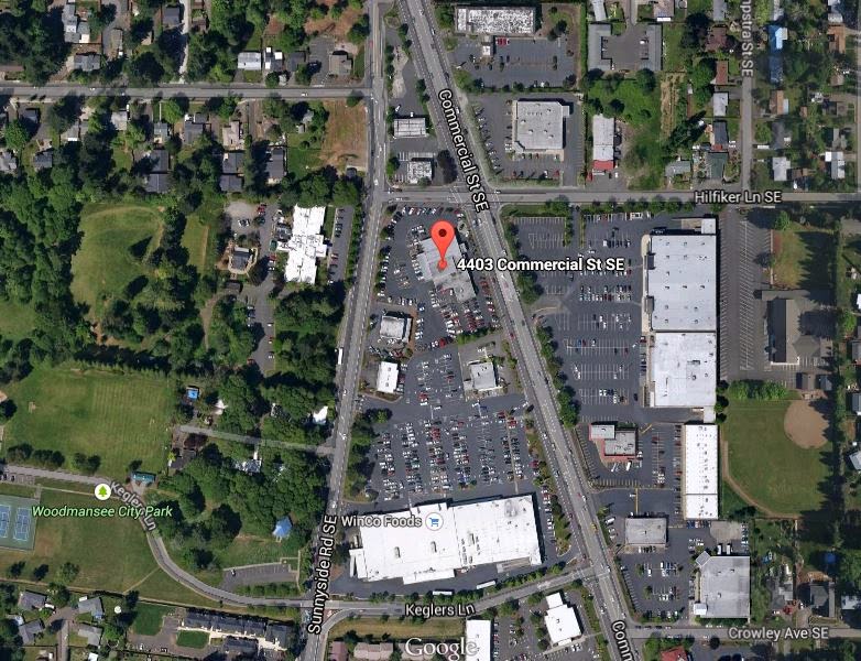
Remember the auto dealership that was demolished earlier this year just north of Winco and across the street from Trader Joe's?

Now Demolished Dealership at 4403 Commercial Street SE
(look at all the blacktop and parking!)
CB|Two is designing a new shopping center for the site at 4403 Commercial Street SE.

Tuesday, October 7, 2014

Crash on Chemeketa Shows Need for Improvements; Beavers Show the Way: Newsbits

Some scattered notes from the paper...

Two Crashes; Chemeketa Still not First-Class Bikeway

Since we started counting in September 2012, drivers have crashed over twenty times into large stationary objects off the road.

Tracking multiple moving objects in space is difficult enough, but if drivers cannot avoid large stationary objects like houses, maybe the underlying conclusion should be that cars are inherently dangerous?

Two crashes
There was a crash also on a primary bikeway into downtown. The details are slightly alarming because the driver of the car admitted to police she "sped up to catch a green light" on Chemeketa and a moped driver, not expecting the speed-up, apparently was making a turn on to High Street and hit the car.

In order to make Chemeketa a first-class bikeway, it needs additional traffic calming and actions to shunt through-traffic over to Center street or the State/Court couplet.

Drivers should never see "speeding up" for a light as an option on a first-class bikeway.

Update on Parkway Car Dealerships

You might recall the announcement that Lithia Motors would be leaving downtown to move the the Parkway.

Talk about Walking, Biking, Land Use, and Transportation Tomorrow

Don't forget, tomorrow on Wednesday, October 8th, James F. Sallis, Distinguished Professor of Family & Preventive Medicine at University of California, San Diego, will give a Healthy Communities talk, "Rx for Better Health: Walking, Biking, and Moving."

(click to enlarge)
A recent add to the program looks terrific!
Sallis' presentation will be followed by an interactive exchange with local officials on specific steps that local governments and citizens can take to improve conditions for pedestrians, bicyclists, and other “active travelers.” The local panel: Linda Norris, Salem City Manager; David Fox, Salem Planning Commissioner; Janice Naimy, Senior Director of Health Innovation, Family YMCA of Marion & Polk Counties; and Garth Brandaw, AIA, Senior Principal, CB Two Architects.
Previous talks along the same lines from Gil Penalosa and Jeffrey Tumlin have not had any formal public engagement with City Staff, and this looks like a solid move in the right direction. Hopefully discussion will be substantive rather than the same old bromides.

More details from the initial announcement after the jump...

Monday, October 6, 2014

Zena's 1853 Phillips House Languishes, Wallace Road Betrays Robert Wallace's Generosity

Did you get out this weekend??? It was glorious early fall!

Sagging barn on Zena Road, early 1900s - it will be gone soon
Don't forget about today's Preservation Pub on our earliest places:
The collection of handmade structures built in the Willamette Valley between 1841 and 1865 embody the culmination the Oregon Trail experience. While their significance to our state’s history is paramount, these buildings are being lost at an alarming rate.
1853 Phillips House Shows Neglect

A ride out to Zena showed lots of old buildings, and one in particular.

Phillips House of 1853 - Vacant since 2002 and in danger
The Phillips House of 1853 is in the same classical revival style of the Conser House in Jefferson. 

By Salem standards, it's really freakin' old! Statehood came in 1859, remember.

Saturday, October 4, 2014

Highway Capacity Expansion Sucks up Safety Resources; Third Bridge Would do Same

News this morning is that a second person has died in the crash the other day that first killed Oregon State Hospital psychiatrist Steven Fritz.

Cary Marie Fairchild died as a result of injuries sustained in the crash.

The crash appears to have been preventable. A cable barrier has been set to be installed at the crash site, and the barriers appear to have a significant affect on cross-overs.

But according to a recent article in The Oregonian, the Newberg-Dundee bypass and Woodburn I-5 interchange expansion sucked up resources that would have been used for the installation:
In 2011, a small pot of money became available [for the cable barriers on I-5] when a Corvallis safety project was canceled. [Tim] Potter, the ODOT manager wrote on Jan. 12, 2012, that construction on the I-5 cable barrier project should begin in the summer, bringing the section into "compliance with current ODOT standards."

But in June 2012, ODOT officials postponed the project because there were not enough resources, Potter said. The reason: The Jobs and Transportation Act of 2009, a massive $800-million spending bill adopted by the Legislature to raise the state gas tax and DMV fees in the name of creating 40,000 jobs.

The headline-making law promised that specific projects coveted by lawmakers would be completed on tight timelines. Specifically, the Newberg-Dundee bypass and Woodburn's I-5 interchange took up money and staff that otherwise would have gone to the I-5 safety project, Potter said.

"The Legislature provided the money for those but there was also a time commitment," he said. "Those two big projects just dominated the resources. In fact, on Newberg I still have resources tied up."
When we consider projects like the Third Bridge/Salem Alternative, we should consider the opportunity costs: Money and time we spend on capacity increases are money and time not available for safety improvements.

New capacity hinders our ability to preserve and maintain existing capacity, and it also hinders our ability to protect road users.

Three drivers hit people on foot

Friday night in the seven o'clock hour, right in the gloaming it seems, three reports of drivers crashing into people on foot came in.

Friday, October 3, 2014

Preservation and Jumble Means Jobs (and beer)!

The weather looks great for wheeling this weekend! It's a great time to think about history as you're out and about.

R.C. Geer homestead from 1878 Marion County Atlas

Back in the spring, you might remember from Salem Weekly the piece about the transformation in process at Geercrest Farm.

Next week on Monday the 6th at Mission Mill, folks from Restore Oregon will be holding a "preservation pub," talking about places like the Geer farm - pioneer-era farms, houses, and homesteads.

The talk arises out of the work for their annual list of "Oregon's Most Endangered Places," and this past year the remaining pioneer homesteads in the Willamette Valley were included as especially at risk.

Historic Preservation League:  Most Endangered Places
Phillips House in middle photo
These buildings from between 1840 - 1865 are often deteriorating, are generally out of the way, and ultimately are irreplaceable.  Once they're gone, they're gone, absolutely gone.

The Geer farm from 1848 is lucky to have a non-profit and education project behind it. A few other homes have been relocated to Mission Mill or other places in town. The McCulley House is fine example of one that's been moved and restored. Other houses have been modified and are a little camouflaged, so to speak.

Smith-Fry House of 1859
You might not immediately recognize the "Edes" house. Today we call it the Smith Fry House, and it's at the top of Gaiety Hill, right by the Library.

A while back the folks at Mission Mill put together a map of buildings and places in Salem that date to this period - and there's more than one or two.