Thursday, July 28, 2022

Climate Action Plan Committee: Cherriots and the Long Range Plan

The Climate Action Plan Committee meets on Monday the 1st, and with some apposite timing they will be talking with Cherriots about transit and the project underway to write the new Long Range Transit Plan.

Interestingly, the City strategies, TL08 and TL09, correspond pretty closely to frequency and coverage. Frequency, it should be noted, has a higher emissions reduction potential than coverage.

On frequency

On coverage

But again, the lead on five of the seven strategies on the agenda is not the City.

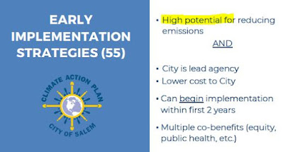
The subset of 55 should have "high" potential (May)

The Committee was going to be structured around a review and decisions on of this subset of "early implementation strategies," and instead the meetings are a series of updates on what other agencies are doing. The meetings are passive, about watching what others are doing rather than initiating urgent action under the City's control. The City was supposed to be the lead agency on the early action.

Wednesday, July 27, 2022

Cherriots Surveys on Frequency vs Coverage

You've probably heard that Cherriots and their consultant is writing a new long range plan. They have a new open house and survey.

Existing Conditions, December 2021

One of the primary questions is whether area residents prioritize frequency or coverage.  Frequency is more buses with shorter wait times essentially on the existing network; coverage is expanding the network for more or longer routes extending farther into neighborhoods.

It is interesting that the question is not regarded as settled. In two previous surveys, both presented to the Board this week, one survey of the general public and one of actual riders, frequency was the highest priority.

Frequency is the top priority

People who ride transit now aren't asking so much for lower fares or fareless transit. They want shorter wait times and more frequent buses. Nor are they asking for more or longer routes for greater coverage.

Tuesday, July 26, 2022

City Council, July 28th - Airport Mania

Council meets for a formal Work Session with two topics on Thursday the 28th.

Eugene welcomed a new airline in August 2021
via FB, Keeling curve added

One of the topics will be Salem's hope for something like this, welcoming a commercial carrier and service with great fanfare to the Salem Airport.

The Staff Report talks about considerable cost for necessary remodeling.

To cost millions of dollars

But it doesn't discuss at all the cost in increased greenhouse gas emissions.

The refusal to evaluate policy like this in terms of climate impacts is just thumbing our nose at the Climate Action Plan, ensuring it is symbolic only and never substantial.

Editorial and inset article from June, 2018

The other topic is an update on the Policy Agenda. Two items are of interest here.

Sunday, July 24, 2022

Checking in on the Fairview Projects

With construction underway on Reed Road this summer, it seemed like a good time to check in on the projects at the former Fairview.

While the New Strong Road is not yet connected and finished, Lindburg Road is complete except for the connection at Reed Road which is blocked and torn up a little.

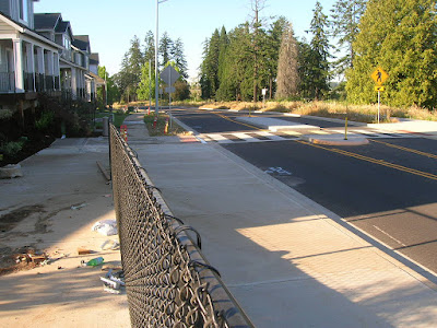
And on Lindburg Road the crosswalks are substantial. They connect from the new residential areas to the forthcoming park area.

Enhanced crosswalk on Lindburg at Shall

At a T-intersection with a new local street, Shall Street, one crosswalk is fully marked and has a center refuge median.

There is no marked crosswalk on the other side, and Lindburg here is not stopped. Only Shall is stopped.

So the downside is that drivers on Lindburg do not stop automatically, but would only stop for a pedestrian in or at the crosswalk. But a person on foot only has to contend with one direction of auto traffic at a time.

Still, the lack of a signed stop on Lindburg might make it more difficult for a blind person. Hopefully the medians exercise a calming function and slow speed on Lindburg.

Enhanced crosswalk on Lindburg at path connection

At the crest of the small hill, as Lindburg swoops down a little to the primary intersection with New Strong Road, there is a second enhanced crosswalk at a ramp and path connection.

From the path connection in the other direction
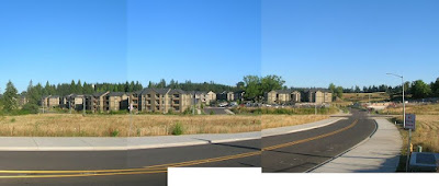
Looking across to The Grove apartments

There is no "village center" yet, and we may find that concept for a commercial hub is pretty well abandoned. We'll have to see.

Saturday, July 23, 2022

City Council, July 25th - Our Salem and new Climate-Friendly Rules

Our Salem is already a little outdated. On Thursday the 21st the LCDC (the board) approved new administrative rules on climate and city planning formulated by DLCD (the State agency).

Cover of the Staff presentation to LCDC

Some of the rule changes will supersede or modify policies and code for Our Salem, which Council looks to enact formally with a second reading on Monday.

From the DLCD press release

I guess the benefit is now City Staff get to point the finger at the State when people complain, so in there is political cover in that sense. "Our hands are tied."

But it's also disappointing the City isn't following our Climate Action Plan and going further on their own. (See a little more on the passivity and reaction in "Climate Action Plan Committee: Transportation and Passivity.")

I am sure Staff will come to Council later with an update on another set of code and policy changes to bring Salem into compliance with the new rules. It will be interesting to learn where exactly are the new inconsistencies. There is also an explicit set of new tasks the rules assign to each city and area. (The chart is too abbreviated to be very legible, and obviously there will be more to say about it later - but it gives a holistic sense of more work to do.)

Salem area compliance tasks

In the meantime, at Council for Our Salem the second reading is broken up into four pieces:

Staff identify next steps:

  1. Update the Transportation System Plan to align with the updated Comprehensive Plan
  2. Update the Comprehensive Parks System Master Plan to align with the updated Comprehensive Plan
  3. Coordinate and implement strategies in the Climate Action Plan
  4. Conduct a new Economic Opportunities Analysis
  5. Conduct a Goal 5 inventory
  6. Develop a Housing Production Strategy

And to this we will add a seventh, which itself contains multiple actions (see chart above): 

7. Update everything for compliance with the new Climate Friendly and Equitable Communities rules.

Friday, July 22, 2022

City Council, July 25th - Capitol Street between Center and Market

At Council on Monday there is an interesting proposal to think about a 3/2 safety conversion with a buffered bike lane for Capitol Street NE between Center Street and Market Street.

Three wide auto travel lanes at Mill Creek on Capitol

On the surface it follows logically the unsuccessful proposal for a system of protected bike lanes in the bond, and also the successful proposal to complete the eastern portion of the Union Street bikeway with full connections to the Esplanade.

Capitol Street here appears to be overbuilt for car travel.

The traffic count between Union Street NE and D Street NE showed a total daily traffic volume of 12,900 vehicles. The traffic count between D and Market Streets NE showed a total daily traffic volume of 12,800 vehicles. These traffic volumes are within the range that two travel lanes could accommodate and present an opportunity to consider removing a travel lane to accommodate a bike facility.

Capitol Street northbound is also part of a one-way couplet with Summer Street southbound. Summer Street in this section has only two car travel lanes, a bike lane, and two strips of parking. Another reason to redesign Capitol Street is to bring it into a symmetry with Summer Street. (But we might also ask, why not more protection on Summer Street also?)

Summer St north of D, with two auto travel lanes only

Though few students are probably coming from the south, a bike lane on Capitol also would connect directly with Parrish and via D Street with North High.

There are real reasons to consider the proposal.

Yet the concept fits a little uneasily with adopted plans and looks to be an example of planning something before we have executed on a previous plan. It could be planning churn instead of good sequencing with construction to realize a previous plan.

Back in 2018 Council formally adopted the Winter Maple Bikeway Plan. While the City has made actual progress on the residential segment between D Street and Pine Street, the segments north and south of that remain unfinished.

Maple-Winter Plan for downtown (2018)

In particular, there is already a plan for buffered bike lanes on Winter Street between Court Street and D Street. But no progress has been made on this.

Capitol here is a high-stress section
our online bikemap

As part of the conversation on the proposal for Capitol Street, the City should formally address how this new concept fits with plans for Winter Street downtown.

More bike lanes is always a good thing, of course! If we are going to meet our climate goals, every street needs provision for bicycling.

It will be great to learn more, and maybe there are very good reasons to move forward with this. 

Other Council items will be in a separate post over the weekend.

(See all previous posts on the Winter Maple Plan here.)

Thursday, July 21, 2022

Costs on I-5 Widening for Kuebler to Delaney Road Skyrocket: At the MPO

The Policy Committee for our Metropolitan Planning Organization meets on Tuesday the 26th, and they look to endorse adding $14 million to the I-5 widening at a short section south of Kuebler Boulevard to Delaney Road.

Buried in a bundle of amendments

You may recall previous rounds on the project. Because of various ways the project has been defined, it has been hard to get a bead on it. In conceptual planning it was a $48 million project.

The first budget had it at $18 million, considerably smaller.

Then it increased to $35 million.

And now $50 million.

See previously:

Sometimes ODOT plays with a slippery scope in order to show a smaller cost estimate at first and then gradual increases that seem easier to swallow. Other times ODOT just plain underestimates. And now we are objectively in an environment of escalating costs. So some combination of all three of these may be in play.

From ODOT approval forms

As leverage, ODOT threatens "there will be a bottle neck on I-5" if the project is not funded, but gives no attention to induced travel and increased emissions.

Back in 2015

Just as for an order of magnitude comparison, you may recall back in 2015 when Amtrak Cascades needed $10.4 million and the two-year budget for the Oregon portion was $28.1 million. So ODOT proposes to spend about twice that on a very short segment of I-5.

Wednesday, July 20, 2022

Farm Story Follow-up: Climate and Land Use

Today's "day in the life of" feature on a local farm was pretty neat, and nice to read.

Front page today

The genre has its own demands, and newspaper space considerations impose still others. But there is so much more to say.

A story just last month, and a different farm

As we read about new protection for farm laborers, and also about the tremendous heat wave in Europe, the micro-scale of a single day on a farm misses a more historical macro perspective. 

Tuesday, July 19, 2022

Legislative Committee with Priorities for 2023 Session

The City's Legislative Subcommittee meets on Friday the 22nd, and the agenda has a number of interesting items. There is no packet or other explanation with the agenda, and there might be more to say later.

Agenda

Unsurprisingly since they left it out of the bond proposal, the City appears to be asking the Legislature for money to stabilize the bluff face over south River Road.

So much speeding: The Police said "eye-opening"

More interesting is what may be a stronger embrace of photo speed enforcement. The bill referenced in the agenda item, SB 560 from 2019, did not pass. It was an attempt to allow all cities in Oregon to employ photo radar. Apparently existing statute explicitly excludes Salem? That is hard to square with our current installations, however. So that will be interesting to learn about more.

SB 560 from the 2019 session

There are also notes about seeking funding for Peace Plaza, for connectivity across OR-22 at Cordon Road, and strengthening the framework for sweeps of camps along "dangerous roadways or environmentally sensitive areas."

Front page yesterday

Or how about just more housing and slower roadways rather than more sweeps? Yesterday's story was about race, but class and housing status may be more directly relevant here in Salem.

Monday, July 11, 2022

Reviewing Chapter 4 of the draft 2023 MTP, and a Digression on TDM: At the MPO

The technical committee for our Metropolitan Planning Organization meets in Tuesday the 12th, and they are reviewing an early draft of chapter 4 on existing conditions for the 2023 Metropolitan Transportation Plan (formerly RTSP). Here's some incidental notes in passing with a longer discussion of Transportation Demand Management.

Start of Chapter 4 in the early draft 2023 MTP

There's a map with "critical urban freight corridors," and it shows the SRC.


This map of freight routes shows the SRC

The chapter is very much a draft, again, and that's the kind of detail that might be an accidental vestige of the 2019 RTSP/MTP carried forward, but it's also a detail worth keeping an eye on.

In a section discussing bicycling and the "regional bike system" they mention a barrier as "community consensus on the validity of implementation." This is too anodyne. It ratifies the idea that bike lanes are optional, not that they are a fundamental baseline. It might be more accurate to talk about "community resistance" rather than the false balance of "consensus."

Sunday, July 10, 2022

From Jessie Dalrymple to Mrs. Joseph H. Albert: A Cycle in Bicycling

Earlier this week the Mill posted that great cyanotype of the Fourth of July parade on Court Street in 1892. A strong candidate for one of the women cycling is Jessie Dalrymple. She seems to have biked mostly before marriage and not so much, if at all, afterwards. It's hard to disentangle gender and class, however. Her story, as we can sketch it here, and perhaps later say more if new evidence comes to light, might really illuminate bicycling in Salem society during that first great bike boom of the 1890s.

Myra Albert Wiggins (l) and Jessie Dalrymple (r)
at Myra's wedding (detail)

We've actually seen Jessie before, at Myra Albert Wiggins' wedding in 1894. 

Myra and Fred Wiggins had met bicycling. With Otto J. Wilson and Myra's brother, Joseph, at least five people in the wedding party are known to have biked. Others are possible, even likely.

Joseph Albert, as we saw yesterday, was son of an important banker and later a banker himself.

Albert-Wiggins Wedding, Nov 24th, 1894
(Oregon State Library)

Jessie had in fact married Joseph, a year after Myra's wedding, in 1895. (He's kneeling directly in front of Jessie.)

November 13th, 1942

January 3rd, 1939

Joseph was, at least for a while, a figure in Salem bicycling. An early bike club, the Chemeketa Bicycle Club, organized in May of 1887.

Saturday, July 9, 2022

Where's Joseph? Wallace Marine Park and a Missing Name

Popular names in ordinary, colloquial usage often operate somewhat independent of official names. We talk about Bush Park, not always Bush's Pasture Park. The Peter Courtney Bridge hasn't seem to stick, and the Minto Bridge or Taco Bridge seems more usual. You will think of other examples. This is a very regular thing.

There is in Wallace Marine Park a marble plinth that suggests another instance of forgetting or simplification in popular revision.

Dedication to Joseph H. Albert
and Paul B. Wallace

At the south end of the north parking lot, in between the Union and Marion Street Bridges the stone reads:

This park is dedicated to the City of Salem by
Joseph H. Albert
Paul B. Wallace
With the hope that succeeding generations may enjoy the facilities for recreation and relaxation, and may grow in appreciation of the beauties of our Willamette River.

Between the Union and Marion St Bridges

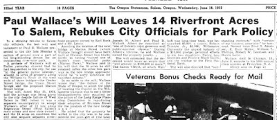
Here's a sketch of some of the history of Wallace Marine Park. It suggests a much more varied origin and set of intended meanings!

Jun 18th, 1952

Friday, July 8, 2022

City Council, July 11th - MLK Parkway

After the proposal to rename Center Street ran into difficulties, the effort shifted to the Parkway, and with blessings from ODOT and the Oregon Geographic Names Board, the way looks clear. 

On Monday Council looks to ratify and adopt the name change, to "Dr. Martin Luther King, Jr. Parkway."

To rename Salem Parkway

That seems like a fine move. The full name seems likely to be shortened to "MLK Parkway" in casual conversation, and the rhyme will help fix it in memory without any significant loss of meaning.

At the same time, it is a little odd that there is no public comment specifically in support of the shift from Center Street to the Parkway yet from our NCAAP chapter or Oregon Black Pioneers. More comment is sure to come over the weekend.

Here's how many Salemites would have been introduced to Dr. Martin Luther King, Jr., in what appears to be his first substantial notice in the paper, when he was arrested "on charges of violating Alabama's anti-boycott law" in 1956. His house, the piece in the afternoon paper points out, had been bombed the month before while he was leading the boycott. The morning paper does not appear to have published anything about him. Its corresponding piece about the boycott on February 23rd, and in immediate follow-up the rest of February, mentions Rosa Parks only. (See also an earlier note on the boycott that also mentions her, December 6th, 1955. Gaines Street still seems worth more discussion as a candidate for reconsideration.)

February 23rd, 1956

In other action, Council will get an information item on the initial approval and subsequent appeal of a proposed food cart pod in West Salem at Riverbend Road. The appeal claims there is not enough parking, will be too much noise, more garbage and rodents.

Wednesday, July 6, 2022

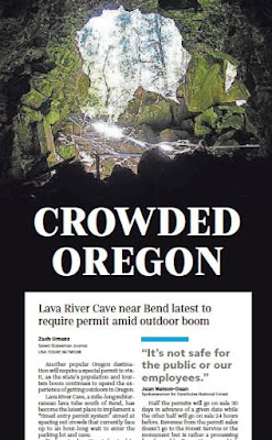
More on Wilderness Decongestion Pricing

The front page today has another piece about decongestion pricing for park and wilderness. There is now, it seems, a steady drip-drip of stories about permits for these areas where there are too many people trying to use an outdoor resource that had previously been "free."

Front page today

Front page last month

The stories get framed up, especially at the headline, summary level, as a loss, as an unfair cost imposed on the citizenry. A revenue grab by greedy government. Punishment.

But what is really being harmed by the crowds is the outdoors itself and our enjoyment of it.

As these permit programs are being implemented, suffer criticism and pushback, are adjusted, and finally settle into effectiveness, there might be resources for talking about road pricing and parking. 

Tuesday, July 5, 2022

Climate Action Plan Committee: Transportation and Passivity

The Climate Action Plan Committee meeting originally scheduled for July 6th has been postponed to Monday, July 11th. They'll be focusing on transportation and land use this month.

LA Times, Sunday front page

First, though, let's take a brief detour to the newly amended infrastructure bond proposal. The City sent out a press release on Friday.

From the Friday press release

On the one hand, the Davis Road and Union Street projects are valuable, not bad ideas at all. (But again, Union Street is a restoration of a segment that had been cancelled, not some new expansion, and we should not oversell its significance as a new thing.)
But the "careful trimming" the City praises exemplifies the way we largely keep auto capacity untouched and instead cannibalize from other valuable walking and biking projects. Non-auto transport is still fighting over table scraps. Council and Staff funded the new inclusions with these deletions:

  • $450,000 by eliminating railing replacement from the 15th Street Bridge improvement (structural improvements will continue at $460,000)
  • $1.5 million from sidewalk infill
  • $1.29 million from sidewalk replacement
  • $3.96 million from Safe Pedestrian Crossings

The only time car capacity was touched is "$1.1 million by eliminating right turn lanes from the State Street Project."

The approach to the bond - for the next decade, very nearly the period over which we are supposed to reduce our emissions by 50% in 2035, it must be stressed - does not adequately respond to our climate crisis and the need to reduce emissions from driving.

"Complete Salem's sidewalk network" - TL03

After all, the Climate Action Plan says to "complete Salem's sidewalk network." We should be doing as much expansion of sidewalk and bike lane as we possibly can, not deleting some sidewalk and bike lane to fund other sidewalk and bike lane. These kinds of projects need to be additive. It should be more, more, more, not "balance." Even when there are other funding sources available, "new grant sources," we should push for the maximum on these, not retreat to a false sense of balance.

Monday, July 4, 2022

4th of July Bike Parade in 1892 Shows Women Biking

The Mill posted a very nice detail of a cyanotype this morning. They didn't say much about it, however.

A child followed by two ladies

It has people bicycling! And not just men, but what looks like a child under a parasol and several women on bike also.

The full detail WHC 81.9.1.3 (1892)

The day after the evening paper published a story about the celebration in 1892.

July 5th, 1892

Included in the long order of parade was the Bicycle Club.

Saturday, July 2, 2022

From Semaphore to Sign: Traffic Control Develops in 1920s

I'm not yet 100% positive on this, but provisionally I want to suggest that the very first non-human traffic control signal in Salem for streets without a rail crossing came in 1922. Here's a sketch of some of the history.

July 1st, 1922 and Cleveland Police Museum

The "semaphores" here might be these right-angled ones like the Cleveland Police Museum shows, with "stop" reading in one direction and "go" reading perpendicularly. The flags could also just be like the stop/slow flip signs construction flaggers use. I hope to find an illustration at some point.

April 23rd, 1921

This was part of the first attempts to regulate and standardize traffic control, which registered here in the early 1920s. The modern tri-color signal head had just been proposed a year earlier in 1921.

But it wasn't until 1937 that Salem actually got such a signal.

August 18th, 1937

While there had been stops for railroad crossings, for intersections wholly separate from rail stop signs themselves seem to have been introduced circa 1926. Council passed what may be the first stop sign ordinance, a "through street ordinance," in December 1925, and the primary reason was to speed up "traffic through the center of the city." Safety at intersections was a secondary consideration. Autoist convenience was the main thing. (See a more general history of the stop sign here.)