Thursday, October 31, 2013

Halloween

Not to be too gloomy, but between Day of the Dead and the recent loss of one mid-century building, another mid-century building comes to mind.

Sometimes when you're in the library or walking by, you can see a puff of smoke and the heatwaves shimmering the air.  It's a moment to say a prayer, tip your cap, or however it is you honor the departed.

Virgil T Golden Building at Sunset in Fall
This one, like most mid-century buildings, runs horizontal, not vertical. They don't use surface area very efficiently. They sit on parking lots and express the logic of auto-distance, not walking distance. They were built when energy was cheap and suburbs seemed like the answer.

Virgil T. Golden Building Midday in Spring
But while we've given attention to the 19th century Victorians, the streetcar era storefronts, and the early 20th century Bungalows and Craftsmen, hardly any consideration has gone to mid-century modern buildings.
Contrasts:  The great play of corner and curve
Not all of them are worth keeping, but at least some of them offer interesting details or historical significance, and it's time to start thinking about them and how they fit into the urban fabric. The National Register of Historic Places uses a fifty-year rule of thumb and Salem's buildings from 1940 - 1960 deserve more attention and consideration.

Wednesday, October 30, 2013

3rd Bridge Oversight Team to Meet Salem Alternative on Halloween - Updated

Tomorrow, Thursday, October 31st, the Salem River Crossing Oversight Team meets to hear analysis of the "Salem Alternative."

June 24th Presentation to City Council of "Salem Alternative"
It's not clear whether the analysis will then formally become part of the draft Environmental Impact Statement. The project team is rather close with the details and information right now, and it certainly would have been nice to have the report posted so that members of the public could actually have something new to say on it during the public comment periods.

As it is, the agenda anticipates a meeting on February 6th, and hopefully no decision would be made before then. Surely this is just an "information" meeting, right? Right?

Trick or Treat:  The Halloween Agenda
N3B has posted here and here on the meeting, and they are hoping to get information on its projected cost and ability to ease congestion.

The meeting runs from 11:00 am to 2:00 pm at the Mid-Willamette Valley Council of Governments, 100 High St. SE, Suite 200, above La Capitale/Bar Andaluz.

(Bonus:  Be sure to check out the costumes! Maybe Clown,  Phantom Tollbooth, and Sexy Traffic Forecast Model?)

Update!  Here's the Sexy Traffic Forecast:

Moving the deck chairs
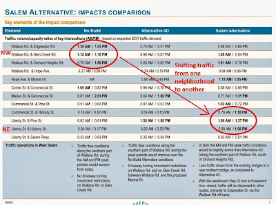
First off, there are serious reasons to doubt the whole traffic model.  But if you accept the model, the internal logic shows that you're not reducing congestion as much as shifting it from a higher income neighborhood to a lower income neighborhood, from West Salem to Highland.

Here's the traffic and other impacts comparison.

Here's the whole presentation to the committee.

A map and a really big map.

N3B also notes the following changes:
the Salem Alternative has morphed once again. It changed a number of times during the time the Salem City Council was considering it. Today it looked very different than it did when the Salem City Council approved it. Here are some of the major differences:
  • In the new Salem Alternative, the [Rosemont] exit off Hwy. 22 westbound is closed.
  • In the new Salem Alternative, Marine drive connects to an elevated span westbound that runs along the bank of the Willamette next to the water.
  • In the new Salem Alternative, the eastside bridgehead is elevated over Front St., not at grade.
  • In the new Salem Alternative the Oversight Team hopes to redesign Marine Drive, which traverses Wallace Marine Park, to be an arterial street -- an "expressway" as Keizer City Councilor Cathy Clark put it. (However, as presented, there are still about six streets that intersect with Marine Drive in West Salem. Some will need to have traffic signals. What kind of an "expressway" is that?)
  • In the new Salem Alternative, the bridge is not a "signature bridge" as the Salem City Council desired.
More to come....

Tuesday, October 29, 2013

Commuter Rail Open House Next Tuesday, November 5th

It's time to start thinking about commuter rail again.

The Oregon Passenger Rail project has an Open House coming up a week from today, on Tuesday, November 5th.

It'll be from 5pm - 7pm at the Chemeketa Center for Business and Industry on 626 High St. N.E.

Detail of Salem Area Alignments
Middle Section, Albany to Wilsonville
(rotated 90 degrees)
From the site:
As part of this project, ODOT and the Federal Railroad Administration are preparing a Tier 1 Environmental Impact Statement (EIS). This environmental review process will help ODOT and FRA make a number of important decisions, including selection of the general rail alignment and communities where stations would be located. The project will also determine several service characteristics, such as the number of daily trips, travel time objectives and the technologies to be used (for example, whether the trains will be powered by electric or diesel-electric engines).
We're beginning to see some winnowing.  At least in and around Salem, it looks like the Oregon Electric line along River Road South, Riverfront Park, and through the Highland neighborhood has been eliminated.

Still in play is a new alignment along I-5 and an old one along the current Union Pacific line that Amtrak uses.

Sunday, October 27, 2013

Demolished Cooke-Patton House and the Civic Center Debate

Let's start off with a tribute to Lou Reed, here asking maybe the most important question. Godspeed.


In today's paper there's a different note about loss, about the Cooke-Patton House, demolished for the State Library and Capitol Mall expansion after the Capitol fire of 1935.

Cooke-Patton House Demolition, 1939
Current site of State Library
Salem Library Historic Photos
The residents of the "Piety Hill" neighborhood north of the Capitol, both Salem's "upper class," and more "middle class," were an important part of the 24/7 purchasing power that kept downtown merchants busy and made downtown lively.*

Piety Hill Neighborhood from old Capitol
Cooke-Patton is the right-most in the inset series
Today the government offices empty at 5pm and on weekends, and don't nourish downtown in the same way. The remaining residential districts are father away, and people don't walk or bike or even drive to downtown very often.  Even if the distance is only a mile or two, for many it feels "far."

Approximately Same View Today
I don't think there's a direct lesson here for the Civic Center discussion, but as we talk about seismic retrofits for City Hall and the Library, we need also to be talking about how we invest in public space - how we formally organize places like plazas and landscaped ponds, streets and sidewalks, and how we configure informal spaces, even the spandrels and other interstices in the ostensibly "empty" spots between where we deploy new buildings or expansions.  Not just where do we put things, but how do they relate, and how do we move through them.

Saturday, October 26, 2013

City Council, October 28th

Council agenda items can be handled this week in bullets.  There's nothing substantial of interest for transportation.

What will replace McKenzie Hall?
At the North State Hospital Parcel, McKenzie, Yaquina, Santiam, Eola,
and Breitenbush Halls are not likely to be preserved.
Since the redevelopment would remain inside the Historic District,
Council would like to be able to review the design of new construction.
 Items:
  • Construction Deferral Agreement "Activations" on Skyline Road  Instead of requiring road widening at the time of construction permits, the City obtained agreements that the developments would pay for the widening when the whole road was done.  With the road bond project starting, it is time to collect the fees for the these construction deferral agreements.
  • Ex-Parte Contact problems!  The road plan for the Bella Cresta subdivision out on the extension of Mildred Lane and Skyline was not yet finalized when a City Councilor - discreetly left unnamed in the staff report - talked about it to the neighborhood association prematurely.  The Councilor was busted and so the hearing needs to be reopened.
  • The annual Planning Commission report is pretty empty.
  • And there's the first reading of the new ordinance to "provide City Council the authority to initiate review of Major Historic Design Review decisions for new construction."  Council will schedule a hearing and there will be more to say then.
To get urban 3-lane standard:
Skyline Road. between Liberty and Kuebler,
to get sidewalks, bike lanes, and center turn pocket.
(It's nice to see the Saturday paper have a preview of Council instead of waiting for Sunday or even Monday!)

More on the Civic Center after the jump...

Friday, October 25, 2013

Lottery-backed Funds for Kroc Center Path? Salvation Army Opposes Gambling!

Wednesday's online note and Thursday's front page article on the proposed path at the Kroc Center have brought out the usual cries of "no tax-payer-funded frivolities," but even if you think a path would be a boondoggle, it wouldn't exactly be funded by taxes - the proposal on the table is to use ConnectOregonV funds, so would it be ok if funded by video poker, lottery, and scratch-off tickets?

Buy a lottery ticket,
Support a path
And more interestingly, what would the Kroc Center think?

Here's what the Salvation Army has to say on gambling:
The Salvation Army is opposed to gambling. The nature of gambling lends itself to exploitative, deceptive and manipulative practices. It is contrary to Christian principles of love, freedom from oppression and concern for others.

As such it should not be a means of income generation or economic development, whether by government agencies, charitable organisations, churches or commercial interests....

Gambling is becoming increasingly common and accessible, often promoted and enabled by governments. Gambling may be large and sophisticated – such as lotteries, casinos, slot machines, online gambling or sports betting – or small and loosely organised informal games of chance.
Kinda interesting, don't you think?

And what kind of public investment in infrastructure is appropriate for a what is, in addition to being a youth center, a church enterprise, a high-gloss Mission of the Salvation Army?

Wednesday, October 23, 2013

Corvallis Features Cemetery Path and Nearly 100% Bike Lane Coverage

On a field trip over the weekend to Corvallis it was possible to visit the Crystal Lakes Masonic Cemetery. The way the historic cemetery manages foot traffic and security at one time seemed like a fruitful comparison for ways we might think of managing foot traffic and security in our own Pioneer Cemetery.

But as seems to be the case of late, comparative data from other places is rarely persuasive.  So maybe this is not useful.  Anyway...

Crystal Lakes Cemtery Walking Path Opening
Signage:  Dogs on Leash, Closes at Dusk
Bordering the cemetery is the Crystal Lake Sports Field, a very large complex of baseball and soccer fields, Lily City Park, and a new 34 unit condo development, Coho Ecovillage, at the southern edge and sharing the cemetery parking lot.

Crystal Lake Cemetery in Corvallis (center)
borders sports complex and housing
Cemetery custodians had reported that the condo development, a cohousing arrangement, rather than bringing hippie riffraff, as was initially feared, instead has brought increased security to the cemetery!

Eyes and ears - people who care.

CoHo Ecovillage;  Cemetery on R in map
The northern edge, has a footpath opening (at top) signed for dogs on leash and that the cemetery closes at dusk. That path leads to the path system that circles the sports complex.

The axis of the path is north-south only. While a map suggests an east-west access would be more useful, more directly connecting the neighborhood and sports complex, there is a slough on the east edge of the cemetery that would make this more difficult, and it is logical that the cemetery would use the slough as a natural barrier.

So the walking path is low-key and not something that is highlighted. It is neighborhood and local lore, not something the City or County officially maps or promotes.

But it shows that it is possible to have a walking path through a cemetery that enhances security and historic values.

Tuesday, October 22, 2013

Area MPO Meets Today; Rideshare to Refund 3 Parking Stalls Worth of Funding

Our area Metropolitan Planning Organization meets today at noon, and there's a couple of interesting items on the agenda.  The first item of interest, a refund of $72,000 for transportation demand management activities, shows the inconsistency - even insanity - of our current funded priorities (as opposed to unfunded policy rhetoric, however sweet).

Back in 2009 in a discussion of the local allocation of STIP funding, the meagre amount we formally spend on programming that supports trips other than drive-alone stood out.  Back then, according to Cherriots,
The amount allocated is the entire budget for the Rideshare program. It does vary from year to year but it has been around $225,000 (total) each year which must cover all of the Rideshare program activities, salaries, benefits, marketing and outreach.
What was true then is true today:  That's crazy! They work to promote and facilitate essentially all transportation options other than the drive-alone-trip. And that's all we give them.


By comparison, In 2009 the widening at Wallace and Glen Creek was projected to be about $9M. 


So RideShare was getting about 2% annually of the total cost of the Wallace and Glen Creek project. 

Since then, the Wallace and Glen Creek project seems to have climbed to around $15M, maybe even heading to $16M.  The exact numbers aren't important.  It's a lot more than $9M.

Monday, October 21, 2013

Win a $2,600 Custom Bike in the Drive Less Challenge

Win stuff during the Drive Less Challenge today through the end of the month!

It's a statewide contest, so there will be lots of people involved, but hey. There's a lot better chance to win this than the lottery!

The grand prize is "a $2,600 custom-built bike with trailer and carrying case by Bike Friday."

See the flier for more!  (Cherriots didn't include the info on the website, apparently, and instead committed to old-school dead-tree direct mail - "Watch for the Cherriots mailer."  Huh.)

Cherriots flier with prize information
But wait!

Saturday, October 19, 2013

Pictures of the City Hall and Police Station Concepts

So what's the City to do? In the paper yesterday some suggested that the whole Civic Center and Police Station thing is a secret.

While there haven't been as many details out as perhaps is optimal, the project did receive a large display at the library about three years ago!

Student Concepts for Civic Center and Police Station
Sustainable Cities Initiative Boards at Salem Public Library
December 2010
If a display at the library isn't public enough, what is?

But it's true, then, that there wasn't a new update really until now.  Perhaps the City should have made more effort to show another round of details.  But as a photo in Salem Weekly pointed out, people don't often don't attend open houses or other information meetings.  Even when you're critical of the City on one thing or another, you have to have some understanding of the indifference cycle from their perspective:  Indifference, indifference, indifference, BACKLASH!  Of course, some of this is self-inflicted.  Citizens who have suffered through the Third Bridge public process, for example, would be forgiven for any cynicism or thinking that public participation is nearly pointless.  It's a sticky wicket for sure.

Anyway, information here is better late than never.

While the article in the paper shared some details, over at CB|Two, there are big pictures Click to enlarge the images.  (The City has also buried some of the images in a pdf here.)

Civic Center and Proposed Police Station
Notice Atrium opened, Council Chambers relocated
Image looking south from above Trade Street on Liberty side.
Image: CB|Two

From higher up - City Hall and Police Station
Image: CB|Two

Nearly the whole Civic Center Superblock looking west
from above Waterplace
Image: CB|Two
The drawing's annotations and more after the jump...

Thursday, October 17, 2013

Move Peace Plaza! It Doesn't Work - In Fact, It's Broke!

Tomorrow night, Friday the 18th, some folks are meeting at the Grand Theater at 6:30pm to talk about some of the City's recent projects. One of the notions that seems to be generating concern is the possibility that a new Police Station and associated construction at City Hall would "demolish" Peace Plaza.

While the intent behind Peace Plaza is laudable, the space rarely functions as a gathering place. With City Hall's weekday 9-5 hours on one side, the Library on the other, and two busy, busy one-way streets completing the boundaries, Peace Plaza usually shows the peace of eternal rest more often than anything else. It's dead mostly. That can't have been the intent and design!

So let's think seriously about seizing the moment offered by a City Hall renovation/expansion to relocate Peace Plaza to a more lively site.  And in whatever is left between the Library and an expanded City Hall, let's create a new and different public space that works.

One of the few scheduled events in Peace Plaza:
A Talk and Vigil for Peace in Syria, August 2012
(Notice, however, that the Peace Plaza proper in the distance
is not usable for gatherings!)
As a gathering place, it's a null.  Events are infrequently scheduled formally in the plaza. If it were a good place to gather, you'd think there would be both a greater number of events and a larger diversity of kinds of events.

As a loitering place, it's a little stubborn.  As the Library offers warmth, shelter, and bathrooms for those who don't always have them, the plaza is sometimes a place for cigarette breaks.  Sometimes this can be intimidating, especially for children, families, or solitary women.  It's not an unsafe space, but it doesn't always feel effortlessly safe.

There's not the burble of activity, eyes, and ears that make for a safe and inviting public space.  All people should be welcome - but that means more people, more different sorts of people, and more and different activities.

Is anyone there?
No visibility or intuitive connection from Liberty;
the berm closes off the space on this side
The edges are either inert or full of cars.  The street connections are poor, and fail to draw in people walking who aren't already going to the Library or City Hall. It's isolated. Commercial and Liberty are terrible for walking and biking here, and the Civic Center is low-density, single-use development on a greensward and campus. There's no reason to come here unless you're going to the Library or City Hall. Finally, the concrete and brutalist architecture is full of hard edges and hard walls, and conveys a feeling more like a fortress than friend.

Wednesday, October 16, 2013

Cherriots to Engage Consultant for Comprehensive System Analysis


Recently Cherriots has entered into negotiations with Jarrett Walker, the author of Human Transit, the book and the blog, for a "comprehensive system analysis."

This is perhaps slender for a full post; you'll see there's a good bit of missing information.  On the other hand, it is an interesting development.

The Request for Proposals closed last month and Cherriots received four qualified proposals.   Last month the Board gave approval to negotiate with the high scorer.

Jarrett Walker's Human Transit Blog
And it turns out the winner is Jarrett Walker and his firm Jarrett Walker + Associates.

The RFP itself is unfortunately locked behind a byzantine database wall, the "Oregon Procurement Information Network (ORPIN)."  Ostensibly constructed to ensure fairness for bidders, it doesn't work very well for the interested public and seems on the contrary to erect as many barriers as possible between the public and public documents! And since the contract is not yet signed, Cherriots is not able to say much beyond the public documents - which themselves are effectively out of reach.  (Not very transparent, alas.)

So we'll go with a summary of the Request for Proposals (we're just googling here, and it's at least possible, though not probably very likely, this is bad data, so a little caveat emptor):
The CSA [comprehensive system analysis] will study the impacts of roadway, land use, and demographic changes occurring in the District service areas over the next 10 years that will affect public transit service, and make recommendations for improvement in service in each year.

An evaluation of System operations, equipment, and facility requirements for short-range (1-3 years) and long-range (4-10 years) will be completed. The core of the CSA is a short-range plan that will recommend mode and program changes designed to improve service efficiency, apply resources where they are most needed, and modernize the transit system based upon current and projected conditions within the service area. The CSA should also provide short- and long-range direction in terms of service expansion, equipment requirements, and future facility needs. [italics added]
Presumably once a contract is signed, more information will be released.

The CSA (yeah - you probably think a box of yummy veggies, too, right?) calls out "roadway, land use, and demographic changes" and it will be interesting to learn more about how these factor into the study. Even as we talk about making Salem more bikeable and walkable, we keep plopping new development on the outer edges where it is most difficult to walk and bike and use transit.  We don't integrate land-use and transportation planning very well.  In the aughts, the City and DLCD argued over this very matter, and the City dug in so deeply that the DLCD gave up. This will be another opportunity to discuss some of the matters and maybe execute some course-correction.

Salem's greatest density is on east side around anti-walkable Lancaster
Not anywhere close to downtown, transit center!
Income and ethnicity is obviously a big factor here also
The dark census blocks = a little over 10,000 people/square mile
map from The Atlantic
This study also comes at an interesting time.  Cherriots has really stayed in the background in the debate on the Third Bridge.  It would be a plausible scenario for a transit agency to offer a vigorous defense of transit's power to reduce congestion.  Instead, our agency has been pretty meek, maybe even a doormat, on the Bridge.  Maybe an outside consultant will be able to galvanize the agency. With the seismic work at the Capitol and a cascade of land use changes, including changes to parking on the mall, Cherriots will also have an opportunity to attract new transit users among State workers.  The Keizer Transit Station doesn't work very well as a multi-modal hub, and there will be an opportunity to do a better job with the planned South Transit Station.

Without the RFP, it's hard to know the right level of generality.  Maybe these things are too strategic, too high-level, and that the study will focus more on fiddling with - or optimizing, if you prefer - schedules, routes, and whatnot. It's crazy, for example, that the bus schedule doesn't work for Salem Hospital! And there's still the question of weekend and evening service.

Like with all studies, it's a blank slate and collectively we can do much or do little with them.

(For more on Walker...He's been in-and-out of Portland a lot lately, and recently you might have seen that he gave an interview to Willamette Week.  Here is a link to his recent Center for Transportation Studies talk.  And a group of videos from "A Field Guide to Transportation Quarrels.")

Update

Transit Oriented Development envisioned in
Salem Futures, 2002
(click to enlarge)


Tuesday, October 15, 2013

Council Delivers Free, Unlimited Downtown Parking to Petitioners

From the paper's story about the vote last night at Council:
“It’s going to be a new challenge, but one I think we ought to accept with some excitement,” said Salem City Councilor Chuck Bennett, who made the motion to approve the initiative.

Salem Mayor Anna Peterson said downtown businesses will have to take “personal responsibility” to make free unlimited parking work. Businesses will have to encourage employees to follow parking rules, she said.

The vote to approve the initiative wasn’t unanimous: Councilors Brad Nanke and Dan Clem opposed it.
It's hard to believe this won't be one of those "be careful what you ask for; you just might get it" situations.

There is of course a non-zero chance that proponents of metered parking are wrong. It is possible that free, unlimited parking will be a great boon to downtown and will bring a golden age of prosperity, vitality, and joy.

From here, though, the odds of this seem very, very small.

(And it's important to remember that if this turns out to be the case, we'll be the first to admit that's a win:  The goal isn't for a car-free downtown or anything like that; the goal is for a thriving downtown.  It's just that some of us think a thriving downtown actually is more likely with metered parking, a more walkable environment, and a smaller car/everything-else ratio.  We have the same goal; we disagree significantly on the tactics to achieve it.)

Instead, it seems more likely that local commuters will discover a new source of free parking, that downtown employees will find it all too convenient to park all day in the on-street stalls, those who parked in the garages will move to the free on-street stalls, and that parking petitioners and other merchants will call for increased enforcement as actual customers find it increasingly difficult to find parking.*

Then the question will be how to fund the enforcement? Do we cannibalize general funds - to trot out the tired cliche, do we close police and fire stations to support more parking enforcement? Is this really the policy choice Salemites want to make?

And then we'll likely be back at meters again. Maybe even on a cycle more accelerated than the Parking Task Force originally envisioned.

Some suggest this is would be a "poison pill," but isn't it rather just an empirical test?  Like the closest thing to science we can get in parking and transportation?

Data from other cities has not been persuasive.  So let's get data from right here.  Let's just see if it works.  Maybe it will.  But more likely it seems that it won't.

Working through this may take more than months. It may take a year or two - though the holiday season will be a great test. But it seems almost a sure bet that unlimited, free on-street parking will fail and that the proof will be in the pudding, finally.

*In several places online folks have expressed surprise at the "unlimited" part, and have even said that the petition was about "no meters," not about time limits.  Here's the first clause in the petition:
Within the Downtown Parking District described in SRC 7.010, parking meters and time limits are prohibited for any city-owned parking (on or off-street)...
Sure, there are a few exceptions, but the clear intent of the petition was to ban meters and to remove time-limits.

NEN meets Tonight to Discuss North State Hospital and Road Bond Surplus

Northeast Neighbors meets tonight, October 15th, at 6:30 p.m. in Salem First Church of the Nazarene, 1550 Market Street NE.

Belluschi Clinic Demolished at 13th and Center
Looking north towards Safeway
On the agenda is an update on the North Campus of the State Hospital.

Leland Report

McKenzie Hall (pictured), Yaquina, Santiam, and Eola
are low-priority for preservation, likely to be demolished.
What about the Belluschi Breitenbush Hall?
There will also be discussion of candidate projects for the road bond surplus.

Already, warning signs have gone in next to Safeway on 13th between Center and Marion!

Walking Man Alert on 13th near Marion

Sunday, October 13, 2013

City Council, October 14th - Parking of Course; Also Historic Review

Well, the big item on Council agenda for Monday is the Parking meter petition, but there's nothing really new to say on it. The new staff report has additional details on the budgetary consequences of losing the revenues from moving to a longer "free" parking scheme. (For all the discussion of downtown parking, see here.)

So instead there's a few forward-looking items that are interesting.

State Hospital North Campus:
Pietro Belluschi's Breitenbush Hall not likely to be preserved,
but would require a public process before demolition
In "a future report," the City announced a proposed new layer of oversight in historic design review of new construction.
Currently, Council can only initiate review of historic demoliton decisions. The proposed amendment will allow Council to initiate review of Major Historic Design Review applications for new construction in addition to demolition decisions.
It would be interesting to learn what problem this is supposed to address - what recent Major Historic Design Review was not reviewed by Council and should have been.

Mid-Century building by Pietro Belluschi
without official historic significance
demolished last week without any public notice
One future set of design reviews that could be in mind are ones that will follow from the sale and redevelopment of the North Campus of the State Hospital.  Council will accept an information report and update on the project.  In it is a note about the mid-century buildings of "low significance," led by the Belluschi-designed Breitenbush Hall. The report says, "[the] Developer must obtain both a Stage 2 Demolition Approval and Historic Design Review Approval from the Historic Landmarks Commission."  The amendment would facilitate Council involvement in the approvals process. (For more on the North Campus redevelopment project, see here. )

Saturday, October 12, 2013

Weekend Fun: Death Match Race Walk, LifeSource Fair

This weekend's a great time to say thanks to our great Breakfast sponsors!

If you've never been to LifeSource, the Customer Appreciation Day is a great time to check them out.  Today, Saturday the 12th, from 11am to 4pm there's music, samples, a bbq, and 10% off.


Remember also  the Governor's Cup Coffee Roasters


And Cascade Baking Company

Thanks to all our sponsors!

Fun in the Highland Neighborhood

This is too funny!

The second annual Race Walk to the Death between the Grant and Highland neighborhoods takes place today - at 5pm on Saturday.
There's a race walk race for everyone this year! Divisions include: Ladies Open, Mens Open, 5'3" and Under, Senior Citizen, Kids Race, Head to Head Smackdowns, and the Highland vs Grant vs The World relay race. If you have anything left in the tank- a potluck, good beer, and a little dancing will follow the races.
Spectating will likely be amusing as well! Bike on by.

And you see the life, keep in the back of your mind the destruction wrought here by the proposed giant bridge and highway - and nearly hidden traces of history, like Herbert Hoover's home!

It's just two or three blocks from the races on Hazel.

Herbert Hoover's Salem home, camouflaged and remuddled!
Regular readers will know this was Herbert Hoover's childhood home when he lived in Salem. Virginia Green has written some about it in her timeline of Salem history. You can see an old view with the original roof here.

Race walking video promos after the jump...

Friday, October 11, 2013

Earthquake Prep: When we can't Maintain Existing Bridges, Why $1B for Third Bridge?


A nationwide earthquake drill is scheduled for October 17th, and lots of folks in Oregon are participating.

There's nothing wrong, of course, with focusing on individual safety.

But a lot of the problem with a large earthquake happens well after the quake itself:  Survivors need food, clean water, medical treatment - lots of things that involve the movement of people and goods.

After the earthquake, a lot of brick structures will look like this
Belluschi clinic at 13th and Center
And no amount of sheltering in place will repair broken water mains and sewer lines, trashed water treatment plants, busted up roads, and collapsed bridges.  So focusing on the micro-scale of "drop, cover, and hold" may result in more than a little bit of a pyrrhic victory.

Infrastructure is hugely important here. (And that means the scale of government, not the smaller one of private individuals and self-reliance.)

So let's talk about those bridges.

Thursday, October 10, 2013

Walk and Bike to School Day Gets Nice Press; Memorials, also

So it turns out that Washington Elementary School may be the epicenter of walking and biking to school in Salem!

Yesterday's Walk+Bike to School Day enjoyed nice coverage with a story and big photos on the front of the Mid-Valley section in today's paper.
Washington Elementary School students already walk in greater numbers than most schools around the district, according to a 2010 survey of 2,750 Salem parents. As many as 43 percent walk home, according to the survey. Poton hopes to boost those numbers and to make sure they’re doing it safely.

He often sees students arrive at school on bikes without helmets, he said, likely because families can’t afford them. He is looking for community partners, including the local fire department, to help fill that need.

So far his efforts to get students moving have paid off. As many as 300 students walked or biked to Washington on Wednesday, according to his count.
Washington Elementary School was one of five schools selected for an in-depth analysis as part of Bike and Walk Salem's Safe Routes to Schools recommendations. (The other schools: Englewood, Hoover, and Faye Wright Elementary Schools, and Walker Middle School.)

Map of Improvements proposed in
Bike and Walk Salem's
Safe Routes to School Plan
(click to enlarge)
It may be that if we are talking about "return on investment," this is a part of town where devoting a relatively greater proportion of resources will yield a commensurately greater reward.

Though the SJ piece focuses on Elementary schools, Waldo Middle School is practically co-located here, and as middle school students are significantly more independent and have better judgment than elementary schools, investments for Washington students should enjoy a multiplier effect - though if Waldo students aren't walking and biking much, it would be interesting to learn more about why there is such a difference.

In any case, maybe we need to think hard about focusing a larger proportion of investment here.

Tuesday, October 8, 2013

Office Building by Pietro Belluschi Demolished Today? Whiskey Tango Foxtrot!

A commenter reports that the mid-century modern medical clinic at 13th and Center designed by Pietro Belluschi was demolished today.

Medical Clinic Designed by Pietro Belluschi at 13th and Center
Anyone else gone by the site and can give additional confirmation on this?

Another reader pointed out by email that a broker's website lists it for sale as "land."  So demolition looks all too possible.

The Coldwell Banker listing is for "land" and not a building
While the building is "minor" Belluschi, about him the Oregon Encyclopedia says:
Pietro Belluschi of Portland was an internationally known architect and a key innovator in the development of an elegant modernism, especially in residences suited to the materials and climate of the Pacific Northwest. His work won him widespread admiration and resulted in his appointment as dean of the School of Architecture and Planning at the Massachusetts Institute of Technology....During the second half of the twentieth century, Belluschi was a major architectural visionary in Oregon and the United States. He was admired for his use of fine craftsmanship and careful detailing, his response to regional conditions, and his preference for classical clarity of form.
He was a big deal. Preservation of the building might not have been possible, but that its demolition would occasion no debate and happen in silence in Salem would be a travesty. 

If true, where's the Historic Landmarks Commission when you need them?!  How is it possible to get a demolition permit without raising flags?  WTF!  Geez.

Here is the best list I have of Salem buildings he designed (#7 now gone, and #6 looks to follow in the State Hospital redevelopment):

1. Willamette University Library/ Smullin Hall, 900 State St., 1938
2. Willamette University Science Building, 1941
3. Willamette University Baxter Complex, 1943
4. Willamette University Doney Hall, 1948

5. Oregon Statesman Printing Plant, 280 Church St. NE, 1944
6. Oregon State Hospital, Breitenbush Hall, 2600 Center St. NE, 1945-50
7. Clinic for Clark Campbell and Wulf, 1280 Center St. NE, 1948
8. First National Bank of Portland, 280 Liberty St. NE, 1947
9. YWCA Building, 768 State St., 1946-52
10. Marion County Courthouse, 100 High St. NE, 1950

Drink a toast tonight, friends. Raise your glass to Pietro Belluschi.