Wednesday, December 30, 2015

Eighth Salemite this Year dies While Walking; Mission Street Remains Terrible

As the year winds down, two more crashes on Mission Street have been in the news.

One of them yesterday evening resulted in injuries fatal today to a woman who was crossing the street.

Rebecca Schoff was the eighth person on foot to be struck and killed this year by a person driving a car.

Previously:
Tow Truck Operator Strikes and Kills Woman Crossing Mission Street

Crash Site: Ford jogs with two T-intersections
From the Salem Police last night, the 29th:
The Salem Police Traffic Control Unit is investigating a pedestrian/vehicle crash that left an adult female with life-threatening injuries.

Today at approximately 5:43 pm, Salem Police officers were dispatched to a report of a pedestrian/vehicle crash that occurred on Mission St SE and Ford St SE.

When officers arrived on the scene, they found that 29-year old Rebecca Schoff of Salem had been struck by a Bales and Brady Tow Truck that was being driven by 35-year old Timothy Hall of Salem. Hall remained at the scene of the crash and cooperated with investigators.

The investigation showed that Rebecca Schoff had been crossing Mission St SE at Ford St SE in an area that had no crosswalks, marked or unmarked. Timothy Hall was driving the tow truck on Ford St and was turning left onto westbound Mission St when he struck Schoff while in the special left turn lane on Mission St. Schoff was transported to Salem Hospital with life-threatening injuries.

No arrests have been made and no citations issued at this time, and the investigation is continuing. Anyone with information on this crash is asked to contact the Salem Police Department at 503-588-6123.

Are the Mill Creek and Salem Renewable Energy Office Parks Already Obsolete?

From a large commercial real estate firm, Newmark Grubb Knight Frank, a fancy new management report, "Suburban Office Obsolescence," has been floating around a little bit, and in light of our new Director of Urban Development, and her stated charge to "lend her leadership to ongoing efforts to retain and grow existing businesses as well as attract businesses to Mill Creek and the Salem Renewable Energy Technology Center," it seems at least a little relevant.

The report's main focus is on existing, vintage 1980s campuses remote from city centers.

Salem doesn't really have any of those - though SAIF, the Civic Center, almost all of the projects in whole Pringle Creek Urban Renewal Area follow the campus forms of this model in many ways; the new cluster of State offices out on Fairview Industrial also meet it in some ways; and of course the Kroc Center is a disconnected campus in a more modern idiom. There's some campus influence here for sure.

Closer to the real subject of the report itself, we do have those parcels out by Kuebler and Gaffin Road that we seek to build into a new suburban office parks.

East of Kuebler, the Mill Creek Corporate Center
and Salem Renewable Energy and Techology Center
 are remote from anything except the interstate.
What do they say about location?

Tuesday, December 29, 2015

More on This Year's Century Buildings: Court Apartments and Roth Building

You already knew about McKinley Elementary School's 100th anniversary. There's a few more buildings in Salem also celebrating 100 years this year. Here's a few notes on some of them.

One of the largest building types in or on the edge of the "missing middle" of housing density is the small, streetcar scaled apartment block of a century ago.

Salem has very few of these remaining, and it happens that one of them is 100 years old this year.

Court Apartments - Jan 1st, 1916

Detail of the "middle"

Today, via the google at Court and Cottage
According to the paper's 1915 year-end wrap in real estate,

Sunday, December 27, 2015

Our Habits in Modeling and Overbuilding

Much of the critique and skepticism about planning for a new Police Station is based on what the resulting bond measure will yield in increased taxes. It comes at things from the perspective of the budget of the individual citizen.

Plenty has been said - and will be said - on that, so instead let's consider our habits of modeling and whether there might be other reasons to be skeptical of the planning process for a new Police Station.

Let's take a tour through a couple of local historical examples of planning that seemed "wise and prudent" at the time, but which history has shown in fact to be far from wise and prudent. Consistently, it seems we overbuild things based on aggressive modeling.

(If you know of local civic/public disciplines in which modeling is surprisingly accurate, it would be good to know. Leave a comment about that, if you would. Success is probably relatively invisible compared to the screeching and grinding and protest in the face of failure or inaccuracy.)

Even if you do not agree that the situation with a new Police Station demands skepticism, it should not be a stretch to agree that skepticism is totally plausible and reasonable. It's not crazy at all. And since skepticism is reasonable, it is also reasonable to ask for more proof and argument from proponents.

Modeling Parking Demand

Back in the 1970s, it seemed wise and prudent to build big, public parking garages downtown.

An older facade on the Chemeketa Parkade  
Unfortunately we have found that we don't need them all or we don't need them as big.

Marion, Chemeketa, Pringle all operate ≤ 50% full
There's a huge surplus of parking in City garages.  At peak the Liberty Parkade is about 60% full, and the rest operate under 50% full at peak. And the Urban Renewal Agency struggles with a substantial budget deficit in the parking district.

The garages themselves are also holes of under-productive land and building in the urban fabric of downtown.

Our parking garages are a clear example of overbuilt infrastructure.

Tuesday, December 22, 2015

So What about the Minto Bridge in High Water?

Ever since the January flood of 2012, it has been an interesting question - indeed something of a hobby horse here - to ask how often the Minto Bridge would be closed.

Inset, the river at about 19 feet on the 17th
Main photo, the river at about 25 feet on the 19th
This really only mattered because there was a period when the City was making crazy exaggerated claims for the bridge and trail as a transportation corridor for commuting and errands.
It is expected up to 14 percent of residents will use the route for commuting, representing up to 21,700 non-automobile commuters. - Minto Bridge and Path Master Plan.
That's puffery that bears no plausible relation to reality.

So for a time it seemed necessary to critique it. Fortunately the City backed off and mostly the Minto Bridge is properly framed up as a recreational amenity. The moment has passed, but the question about seasonal closures remains interesting because it's not talked about enough.

So this is basically just trivia, but it's still interesting.

Monday, December 21, 2015

2015 in Review: In Memoriam

It was a strange, sometimes wonderful, but mostly terrible year to walk in Salem, and the increase in people killed while walking is the top story of the year here.

January 29th - and more were to come
In a nutshell, on August 6th at 7:30pm, folks talking a nice group walk set off in the Highland neighborhood, here pictured at Academy and Hazel.

The August 6th walk in Highland
Less than two hours later, and about two blocks away, in an unmarked crosswalk at Pine and Maple a driver struck Caroline and William Storm, killing Caroline. They were not part of the group walk, and were just out walking the dog. There's no causation here, just coincidence. But there's no denying the symbolism and tragic irony.

That's where we are, an awful blend of the wonderful and the unspeakable.

Deaths back over 400 this year, up 20% over last year
via The Oregonian
In general traffic violence and death was up statewide this year. Salem was no exception.

More than anything, it was the deaths of seven eight people, struck down in crosswalks, on sidewalks, and even in a work zone, that mattered most in 2015.

In Memoriam:
The defeat of weekend and evening bus service and the start of construction on the Minto Bridge seemed like the other top stories this year.

Friday, December 18, 2015

Car Dealership Site for Police Station Chance to Fix Terrible Intersection

Last night the Police Station Council Subcommittee met, and over at SCV and Hinessight they've got some detailed discussion of the current state of the debate. Indeed the overall costs remain high and the refusal to include seismic work on the library seems foolish. But here there's nothing new to say on these.

Instead of considering proposed building size and cost - what to build - which others have done plenty well, let's just consider the leading site candidate - where to build - from the long list of eight, and short list of four finalists.

Of the four finalists, the O'Brien parcel at Commercial and Division Streets scored highest by a significant margin.

O'Brien Parcel Sale Flyer
A project here would be across the street from the proposed new United Gospel Mission development, and right at one of Salem's most dysfunctional intersections.

Remember the crash with all the chickens?

Thursday, December 17, 2015

10 Best New US Bike Lanes in 2015

I got nothing today. Instead, check out this list of the best new bike lanes around the country.
If Salem is going to be the "best city in the United States," how about we get ourselves first one of these and then a network of them?

(And a good state-level bike plan would recommend and then require these as best practices!)

Random update - the steeple-like thing made me think of First Methodist. And it seems to me there's a great visual rhyme here with the State/Court Street couplet and what might be done with a protected bike lane going from three car travel lanes to two. Equally, for the Liberty/Commercial couplet.

Western Ave in Cambridge, MA
our own State Street

Wednesday, December 16, 2015

Tell ODOT to Make the State Bike Plan Better!

A couple days ago, keyed I believe to the first formal Open House for the draft Statewide Walking and Biking Plan, ODOT also launched an online "open house" and comment form.

Online "open house"
The plan has for a while seemed slack and toothless.

Even established insider advocacy organizations have concerns. A month ago a coalition submitted comment about its shortcomings.

Tuesday, December 15, 2015

State Street Survey, Ramp Spaghetti, Church St. Sidewalk, Baggage Depot - Newsbits

Lots of interesting bits this week in neighborhood news.

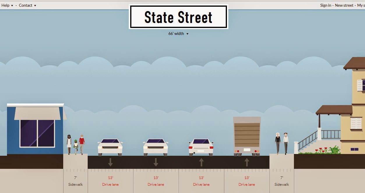
Approximately the current four-lane section
(via Streetmix)

State Street could look more like this!
The State Street Corridor study has the first survey out!

Weigh in on this important study full of possibility for reshaping State Street between 12th and 25th to be more walkable and bikeable, more vibrant, interesting, and prosperous. (For previous notes and posts on the study, see here.)

Monday, December 14, 2015

Amendments to Transportation System Plan also at Planning Commission Tuesday

In addition to the matter of the proposed Goodwill in West Salem, on Tuesday the 15th the Planning Commission will also hear about a suite of proposed amendments to the Salem Transportation System Plan. As the Staff Report introduces them,
The currently proposed amendments are primarily housekeeping. They include:

1. Updated to the introduction (regulatory context, population and employment forecasts, and travel characteristics);
2. Updates to existing conditions in various modal elements; and
3. Recommendations to support the Chemawa-I-5 Interchange Area Management Plan (a regional project conducted with the Oregon Department of Transportation (ODOT), the City of Keizer, and marion County).

This package of proposed amendments will include changes to the following elements of the Salem TSP: Introduction, Street System, Transit System, Transportation Demand Management, Intercity Passenger Transportation, and Freight Movement. Most of the changes are textual edits; however, there are a few minor policy and map amendments. Staff is planning on presenting a package of more substantive amendments focused on changes to the capital project lists and priorities in the future.
As far as I can tell there's no great change of any significance (see correction just below), though the drift of a number of the edits nods to multi-modal change but may actually retreat from substantive change or action.

Not sure the interior shows this same modal balance!
Instead of a drift away from drive alone trips, there's a drift towards them.

Saturday, December 12, 2015

City Council, December 14th - Fairview and the State Hospital

Most of the good bits on Council's agenda for Monday are discussed in other posts or elsewhere, so we'll start with links. At the top is more on the way we approach redevelopment at former State institutional sites.

Le Breton Hall in 2011
You already know about the new plan to demolish Le Breton Hall at Fairview.

Also very interesting is something SCV turned up. The Salem Housing Advisory Committee recommends "12 acres of affordable housing at the North Campus site [of the State Hospital] on Center Street," or approximately a quarter of the acreage that might be redeveloped:
Affordable housing fits the North Campus redevelopment vision. The North Campus is within several established neighborhoods and within biking/walking/transit proximity to concentrated employment at Government and medical facilities.
From the beginning of talk about the prospect of redevelopment it has seemed like this proximity has always been one of the most important features.

It's 10 minutes by bike to the Capitol!
It is good to see some convergence! - for advocates of better transportation, advocates of better land use, advocates for better neighborhoods, advocates for affordable housing all to see this parcel as critical and useful. (Now if the health advocates will weigh in!)

And although not all the buildings are involved, historic preservation is also represented. The most disappointing omission from the current preservation plan, but also one with great difficulties, is the Pietro Belluschi design of Breitenbush Hall. A long and very thin strip, it has a form and site disposition perfect for institutional use, but more difficult for other market-based uses. It hogs up a lot of the land and spacing, and makes it more difficult to deploy other new buildings around it.

Half of Belluschi's Breitenbush Hall - A shallow strip, super wide
and a good distance from the sidewalk across a lawn
So it's probably going be demolished. SCV has details on a tour of Breitenbush Hall at the State Hospital.

Friday, December 11, 2015

West Salem Goodwill at Planning Commission; City Whiffs on Second Street

On Tuesday the 15th the Planning Commission will be looking at the Proposed Goodwill store and development project in West Salem.

Proposed West Salem Goodwill from Edgewater
Formally, it's a "consolidated zone change, class 3 design review, class 3 site plan review, class 2 zoning adjustment, and class 2 driveway approach" and there are 136 pages in the Staff Report and submittal packet.

Whew.

There are a couple of interesting things about it. From here there are details to quibble over, but overall it doesn't seem like anything not to approve ultimately. Staff Recommendation is for "approval" with conditions. But it handles the question of Second Street in what looks to be very wasteful fashion.

Ninety Degree Turn

The first interesting thing, something we've remarked on before, is the 90-degree rotation that puts the main axis and entry on the parking lot instead of along Edgewater.

Thursday, December 10, 2015

Saturday Tour Proposed Fairview Park - See Ruins and Possibilities!

The latest issue of Salem Weekly has the details on an official walk of the proposed Fairview Park area!

Le Breton Hall in 2011

Latest site conditions map - with slopes, views, trees
From the piece:
A tour of the property is scheduled for Saturday, December 12, at 10:00 a.m.

Signs will be posted at the corner of Reed Road and Old Strong Road SE directing people where to park for the tour.
The focus presumably will be on the possibilities for the park, but don't let them get away without talking about Le Breton's proposed demolition! The matter was pulled from Council last week, but it will reappear on the agenda for Monday the 14th.

The estimated cost to "deconstruct" the building is now $250,000, up from the original estimate of $50,000 merely to "weatherize" the building for TBD future uses. The current estimate to weatherize it has also increased:
As due diligence was completed, it was found that the cost to secure and weatherize the building will cost $190,000, mainly due to unforeseen problems with the roof and gutter system....The Seller is willing to absorb $90,000 ($250,000 less $160,000) of the cost of the deconstruction of the LeBreton building in exchange for additional Earnest Money.
There's no outright discussion, however, on why it is preferable to spend $250,000 for demolition and not $190,000 on preservation. This is assumed, not proved or argued.

(For previous discussions of Le Breton, the proposed park, see notes tagged Lindburg Green.)

Wednesday, December 9, 2015

Frank Tanaka's Tokio Sukiyaki House Closes in 1942

Yesterday we noted the Mill's online restaurant history exhibit. One of the most important chapters is the one on Frank Teruhiko Tanaka (1887 - 1980) and his Tokio Sukiyaki House on Commercial Street.
Business was good until international affairs led to increased hostility and discrimination against people of Japanese descent in Salem. Even before Pearl Harbor, the Tanaka family took out advertisements in local Salem publications to show their dedication to the U.S. Despite this patriotism, business dried up at the restaurant and it was forced to close in 1942. Soon after the Tanaka family was forced to leave Salem for an internment camp under Executive Order 9066....They did not return to Salem.
Tokio Sukiyaki (top middle), 1940
Salem Library Historic Photos
Same scene in 2014, via google
In the 1940/2014 side-by-side, you can see the restaurant in the middle at top, above Fitt's. The buildings on the south half of the block, especially at the corner, were heavily remodeled in a moderne style just a couple of years later, so much so that some accounts describe the buildings as new construction. In the contemporary image, you can see the lone remaining part of the Eldridge Block, which was mostly demolished for parking, and which remaining part Greenbaum's fortunately preserved.

More on Eola

You probably have heard before that Abigail Scott Duniway was very early, and for a brief while, a teacher at Eola, way back when it was known at Cincinnati.

Home of Cornelia Marvin Pierce, Salem Library Historic Photos
There's another curious woman with ties to Eola.

Somewhere up in the old town of Eola was the house of former State Librarian Cornelia Marvin Pierce. (Is it still there?)  After she retired from the library, she married former Governor Walter Pierce, who is known to have had connections to the KKK and may even have been a member. "Reflecting on her career in 1955, [Cornelia] characterized as highlights her support of leading eugenicist Dr. Bethenia Owens-Adair, and her husband Governor Pierce's 1923 passage of Oregon's sterilization law."

Sterilization was practiced both at the State Hospital and at Fairview and the Sterilization Board wasn't abolished until 1983.

Tuesday, December 8, 2015

Christmas Citrus in 1915 and extra STP-U funds at the MPO

What a crappy stretch of weather we are having. Here's a sunny and perhaps slightly amusing diversion.

A local history of citrus is well outside our scope here, but the role perhaps of trains is at last somewhat relevant. So we'll go with that.

According to Wikipedia, back in 1907, the Southern California Fruit Exchange, a coop formed in 1893, launched the Sunkist brand and a national marketing campaign.

Here's what the Christmas promotion looked like in 1915.

Full page spread for Sunkist Oranges
December 17th, 1915
Plain oranges are routine now, so it would have to be something like Bergamots to generate any kind of excitement nowadays. Or maybe all citrus itself is too ordinary - and we're back to the Tesla.

Mission Mill has recently started a new web project as an online archive devoted to their physical exhibits. They just published their show on restaurant history and it's worth a look!

Eating Salem website
At the MPO

Also, the Technical Advisory Committee for our local Metropolitan Planning Organization meets today with a fairly light agenda, but they've got a bit more discussion about some dollar bills they found under the sofa cushions.

From the agenda and packet:
Due to the MAP-21 extension, the SKATS MPO will have about $1.0 million more in FY 2015 STP-U federal funds than was conservatively programmed for FY 2015 in the SKATS Transportation Improvement Program (TIP). Five projects were submitted for consideration for funding using the additional funds. See the attached memorandum for additional information
Let's just assume the two Cherriots projects are worthwhile. But the County projects are all hydraulic autoism, all about more capacity and through-put on roads in unincorporated urban land.

It's very disappointing the bonus money wasn't allocated to walking and biking - to the 21st century! - instead of retrograde auto capacity expansion for the 20th century.

This will make its way to the Policy Committee, I'm sure, and maybe there will be more to say then. (Or maybe not.)

Update, the 11th

See comments below for discussion of the particular Macleay & Lancaster project.

The largest impact to NE corner

Monday, December 7, 2015

Why Pedestrian Rights themselves may not be Sufficient

The conversation around the weekend's op-ed on "pedestrian rights" and "safety" seemed mostly all too predictable.


Stay out of the way!
Critical responses and comments to the piece fell into buckets we see quite often:
  • Might makes right: cars are more powerful, so of course it is prudent and right for people on foot to scurry out of the way
  • I am a strong, fast, and defensive walker/biker, and I protect myself; if you are hurt, it is because you have failed to be strong, fast, or defensive, and it's your own damn fault
  • People on foot are a bunch of whining entitled brats, expecting people in cars to inconvenience themselves to slow or stop
  • It's just a matter of civility and politeness; if everybody was nice, paying attention, and not in a hurry, most problems would disappear - "can't we all just get along?"
Much of this recapitulates the basic structure of important debates that we are having in several areas:
  • Is gun violence only the result of bad actors or is it also a manifestation of a system problem? 
  • Is racism only the effect of bad actors or is it something more deeply entrenched in systems?
  • Is poverty only the result of individual bad choices and not trying hard enough or is it an expression of a biased system it is too difficult to escape? 
So is the primary burden on individual road users to make better personal choices, whether they are behind the wheel or on foot?

1937 propaganda - via NYRB
Or do we have a system that makes it difficult for people to make good decisions and actually encourages deleterious decisions and patterns? And then does this system need thorough-going, structural reform?

The position here is that good intention and civility on the part of road users is insufficient in our current system of hydraulic autoism and that we have a system with too much licit jay-driving.

Sunday, December 6, 2015

Rainy Sunday Night Newsbits


This is interesting. From the City:
The 336 Hour Challenge
Experts agree that the next major Cascadia earthquake could keep 25,000 commuters in this region from getting home for two weeks, due to road and bridge damage! Is your business ready to shelter and care for your employees for two weeks after disaster strikes? Are you also prepared at home?

SEDCOR’s Cascadia Threat Series assists large and small businesses in improving their ability to recover from a disaster. Gain the knowledge you need to not only prepare yourself and your company, but to play a critical role in helping the community recover.

The City of Salem is partnering with SEDCOR, Marion County, Oregon Emergency Management and the American Red Cross for this purpose on December 9, 2015 at the Salem Convention Center. There will be lunch and a presentation from noon until 1:30 p.m. Exhibitors will be available from 11a.m. until 2 p.m.

Admission including lunch is $20. To register and learn more go to 336 Hour Challenge.
It seems like there's some increasing realism here about the disruptions caused by the earthquake - even if two weeks seems yet on the short side. If it's as massive as they say, months seems more realistic than weeks.

At the same time, it's still about finer-grained and small-scale preparation for individuals rather than about infrastructure. So still not very much about the massive significance of preparing the Marion and Center Street Bridges. How many State employees and managers live in West Salem and won't be able to reach State offices?

If we assume that the probability of earthquake is evenly distributed, there are 168 hours in the week and 40 hours in a standard workweek. So the odds that earthquake strikes while you are at work are only about one in four - and the more likely problem is  you are away from work and you can't get to work.

It still seems like we're talking about one big camping adventure and not enough about the loss of life, critical services, and infrastructure.

Morningside

The Morningside Neighborhood Assocation meets on Wednesday the 9th, and they've got a few items of interest.

Saturday, December 5, 2015

City Council, December 7th - Zoning and Encroachment

This was going to be more about the proposed demolition of Le Breton Hall, but that was pulled from Council agenda temporarily. So instead, maybe a few more general remarks, and then a couple of interesting zoning and conditional use questions.

Demolition earlier this year at the "Crescent"
That's Kozer Cottage (Fred Legg, 1920) with the mural
On the demolition, it's not like anyone is saying "save all the buildings!" Because plainly they cannot all be saved. At this site it is completely reasonable to demolish many, even most, of the buildings. And a lot of demolition has already been done. That's ok.

But because Le Breton is the oldest, it has the greatest historic value, and it deserves a much larger measure of care, attention, and effort. For the City to give up on it after just four months seems very premature. It may yet be necessary to give up on it, but that should have a time-line measured not merely in a few months. Did the City really think it was going to be quick and easy and not assign sufficient resources to see it through?

(Apparently the McMenamins already turned down an opportunity to redevelop the Dome Building at the State Hospital, and may not be interested in Le Breton, but in light our of own romanesque City Hall, this still seems apropos and a relevant if unflattering comparison.)
Bike Parking at Gaiety Hollow - Tempest in a Teapot!

So on the 25th of last month a formal appeal was filed on the question of bike parking at Gaiety Hollow, the home and garden of Elizabeth Lord and Edith Schryver.

Friday, December 4, 2015

Skyline Before and After: Widening not Unambiguous Benefit, Speeding more Likely

With construction season having wound down, the City's been trumpeting its projects. But assessment of them is always with an autoist lens. Here's a more nuanced look at one of them.

Unfortunately the angle's not the same, but this is a before-and-after of the same stretch of Skyline Road that the City recently widened.

One shoulder only, two travel lanes - Via google

Sidewalks, bike lanes, turn pocket, 2 travel lanes - Via the City
As the City describes the changes:
The Streets and Bridges Bond widened Skyline Road to minor arterial street standards with a center turn lane, proper travel lane widths, bicycle lanes, curbs, gutters, sidewalks, storm drains and street lights between Kuebler Boulevard S and Liberty Road S. We appreciate your patience regarding minor lane closures until all work is completed in December, 2015. Once complete, the improvements made will increase safety for pedestrians, bicyclists, and motorists!
But the rhetoric about increasing safety is only partially true.

Thursday, December 3, 2015

California DOT Acknowledges Induced Demand - More Roads don't solve Congestion

This was making the rounds the other day and it seems at least a little significant and more than a little useful around here.

The California Department of Transportation is in some sense officially recognizing the law of induced demand on roadway expansion and the conclusion that we can't build our way out of congestion with new capacity.

CalDOT's research page
The link: "Increasing Highway Capacity Unlikely to Relieve Traffic Congestion"

ODOT, our local MPO, and our City haven't quite figured this out yet.

But more and more state DOTs and local governments are finding that drivers fill new roads and that the apparent "congestion relief" only works for a short period of time. Trying to solve congestion through more roads and through wider roads just leads to more congestion. It's circular and it's not actually a solution. Moreover, it's an intensely expensive non-solution. Just a waste.

If we want to reduce congestion, we need to consider tools like congestion pricing, better transit, better land use to place destinations closer together, better walking and biking. We need to make it easy to see driving as the transportation choice of excess rather than the choice of economy, prudence, and convenience.

Wednesday, December 2, 2015

City Proposes to Demolish 1908 Le Breton Hall at Fairview

Well this sucks, and if it is the first official act of the Steve Powers administration at City Hall, it's a terrible portent.

Citing higher than expected preservation costs, the City is proposing to demolish the oldest structure at Fairview, Le Breton Hall.

Le Breton Hall shortly after construction at
the Oregon State Institution for the Feeble-Minded
circa 1908 - WU Archives
From a "Future Report" on the park, dated December 7th for Monday's Council meeting:
Staff recommends that the Agreement be amended to require the Seller to deconstruct the building [Le Breton Hall] prior to transferring the land to the City. This recommendation is based on the high cost ($140,000) to secure and weatherize the building; the ongoing annual cost to secure building; the anticipated high cost to renovate the building for an as of yet undetermined use; the lack of funding source for the renovation, and; the lack of funding source to maintain and operate the building after it has been renovated.
Le Breton Hall was designed by Walter D. Pugh, who was also responsible for the Old City Hall (1893), for the Grand Theatre (1900), and the Bush-Brey and Bush-Breyman blocks (1889) on the west side of Commercial between State and Court. Though his architecture isn't always first rate, his buildings have played an important role in the second and third generation of Salem development and history. As an increasing number of buildings at Fairview are demolished, the remaining ones take on a greater importance. Le Breton is the oldest building and the primary one with direct ties to the first stage of the institution, a now embarrassing one in which it seemed reasonable to talk of the "feeble-minded." Scrubbing this history for a park seems mean and cheap.

Oregonian, January 8th, 1911 (Le Breton, top left)
This site is challenging for historic preservation, but feels like the City is now pivoting much too quickly from an interest in preservation to the park and to demolition.

Hopefully more will come out about this change of heart.

(For previous notes on the Fairview parcel, the demolitions, and the park, see here.)

New City Manager says he will Walk or Bike to City Hall

Welcome receptions are love-fests, right? Everybody's putting their best foot forward.

Well, that's a very nice foot forward.

Welcome to town, City Manager Powers.

Bike Map from Crestview to City Hall
The article said Steve Powers was in the process of buying a house on Crestview Drive, so it seems fair to comment on the commute. Crestview, like it sounds, is on the crest of the hill above Candelaria school. Given that as the crow flies it's not very distant at all from downtown and City Hall, it also fairly encapsulates some of the challenges for people on foot and on bike in Salem.

Though Crestview is an attractive low-traffic street for walking or biking, it is in an enclave bounded by River Road, Commercial/Liberty, and the cemetery. Maybe more than anything, this will give City Hall first-hand experience on the barrier posed by the Cemetery.

With a Cemetery connection, continuous and very lovely low-traffic route is possible. But without that, a person has to contend with very busy roads.

It's also hilly, and maps might not reveal how much hill-climbing will be necessary on foot or on bike.

A person who walks or bikes regularly from Crestview will have an effective first-hand experience of the challenges for non-auto travel in Salem. Not all of them of course, but a decent enough sample.

Hopefully he will be a voice for a more balanced transportation system.

Cheers, and Good Luck, Manager Powers!

Tuesday, December 1, 2015

Second Street NW Undercrossing, Portland Road Corridor, Fairview Park - Citybits - and updated

Lots of interesting bits around the City this week...

But first one Cherriots note.
Yesterday was the last day with the free pilot program for "the Connector," the ride-booking service for West Salem operated by Cherriots. Starting today service on it now costs a regular fare.

It will be interesting to see how useage is impacted with the fares. It may not tail off that much, as it was probably serving disproportionately transit-dependent riders who were already using Cherriots. But maybe it attracted some new riders who will be price-sensitive. I don't know. It'll be interesting to watch. The raw count of riders was never very large. Back at the September board meeting an evaluation at the mid-mark of the pilot said:
After 3 months of operation, the service seems to be doing well. We have seen an increase of ridership each month. The service has been used by 133 different passengers. The service is averaging 1.55 passengers per revenue hour (which is just slightly less than our CherryLift and RED Line services) . This is below our target of 3 - 5 passengers per revenue hour...
But the total numbers also round to zero in the big picture, and they may be evidence that in order to make transit scale and be meaningfully effective for large numbers of people in the hills - to make a dent on rivercrossing traffic, that is - tolls will be necessary on the bridge.

West Salem Redevelopment Advisory Board

WSRAB meets tomorrow and they'll get updates on parking in the Edgewater district, on the Goodwill site, on the latest draft of the West Salem Business District Action Plan, and most interesting of all, a proposal to take the Second Street Undercrossing concept to the next level.

Bike Parking Remains Lone Issue Outstanding at Lord and Schryver Museum

The Lord & Schryver Conservancy's fall newsletter came out last month, and in it is an update on the "change in use" proceedings to convert the home and garden into a kind of museum.

November 2015 newsletter
Buried in that update is news on the lone "outstanding issue": bike racks!

November 2015 newsletter
Geez.

Holy Smokes that seems like a crazy disproportion to the actual effect of bike racks. Is this really the bridge on which to make that last stand?

Briefly, here again is why the Conservancy's proposed location is not very good: There's not enough clearance on the alley.

Detail from site plan above; red comments added;
bike parking standards from Portland added as insert

The alley is very tight in places, and bikes and riders
could get clipped - via Gaiety Hollow
It's also of course not within 50 feet of the primary entry.