Sunday, January 31, 2016

Transportation in the Neighborhood Associations this Week

Several small transportation bits are at the neighborhood associations this week. West Salem will talk about "a transportation plan," NEN about the median on 17th and Chemeketa, and Grant about a proposed drive-through.

West Salem - Monday

This one is short and a little cryptic, but might be interesting: "West Salem Transportation Plan Update – Salem Public Works Department," as it's listed on the agenda for tomorrow, Monday the 1st.

I suspect this is the West Salem Business District Action Plan for the Second Street undercrossing and the associated projects, but maybe there's some other West Salem Transportation Plan in the works.

Two other items are of interest as well: "Stellers Eagle / Bald Eagle Concern (Hazardous Intersection due to Parked Cars)" and "Student Parking Near West Salem High School."

The West Salem Neighborhood Association meeting is 7pm at Roth’s West, Mezzanine level, at 1130 Wallace Rd NW on Monday, February 1st.

Northeast Neighbors - Tuesday

The median island prohibits a westbound left turn from 17th
NEN meets on Tuesday the 2nd, and they'll be talking about the intersection of Chemeketa and 17th.
Kevin Hottmann, City Traffic Engineer – Possibility of Removing the No Left Turn Sign on the Median Island at 17th Street NE and Chemeketa Street NE
This bears watching. Would it entail the removal of the island? If we are serious about making Chemeketa a fully family friendly bicycle boulevard, we should probably be thinking about ways to discourage even more auto traffic on it.

On the surface, this looks like a move in the wrong direction.

Saturday, January 30, 2016

Winter Street Bridge Opening Recalls Church Street Bridge Deterioration

The Winter Street Bridge over Shelton Ditch is open again. The City posted it to social media earlier this month, so this is old news. But it's still interesting, and you should check it out on a walk or ride.

Though the bridge is one of several designed circa 1930 by R.A. Furrow, an associate of Conde McCullough, this particular bridge itself isn't that interesting. It was a minor example, one of the lesser bridges in Salem. (See here for more on Furrow and his set of bridges. Furrow was also handled the Commercial Street bridge that was just replaced by the Civic Center.)

The replacement is historically sensitive and they did match the patterning of the old, vintage style fairly well. (Though it seems like the shim and patch you can see below might have been handled more elegantly.)

2016: New concrete (L) and old concrete (R)
From February 2012, a little after the flooding
The railing is a close match and conforms to what ODOT calls a "type D" standard, which was generally used in Salem's bridges of this vintage. (They do insert the cabling to bring it to modern standards.)

But it's not a copy.

Thursday, January 28, 2016

McGilchrist Block Parking a bit Careless, and May not be to Code

Coming into downtown, I never use State Street. Outbound for all but two blocks west of Liberty, it goes in the wrong direction and isn't useful. Consequently, I have never used or even looked at the newish bike parking in front of the McGilchrist block on State Street.

But perhaps very few others do as well. (Have you used this set of racks?)

If you wonder why we harp on bike parking here, well it's because it gets overlooked so often.

Code is perhaps ambiguous, and if you don't bicycle, the code is written in such a way that it would not be difficult to misunderstand what constitutes a "stall" or "space":
Bicycle parking spaces shall be a minimum of 6 feet by 2 feet, and shall be served by a minimum 4-foot-wide access aisle.
Staple racks like these are intended for one bike on each side, and so by code a row of them should be installed with four feet of space between each pole mount. (If you place two 6x2 "spaces" side-by-side, you get a 6x4 box; each staple rack, then, would be centered in a 6x4 box, and the racks spaced on four-foot centers.)

I didn't have a tape measure, but the spacing on these is much closer to two feet than to four feet (maybe the concrete seams are on three-feet spacing?). If you considered each staple rack as having only space for one bike, then there would be two feet of space, and it might appear they meet code. But if you intend for each rack to hold two bikes, then they do not meet the intent of code.

Wednesday, January 27, 2016

Downtown Redevelopment Candidates and Union Street at Commercial: DAB Tomorrow

The Downtown Advisory Board meets tomorrow, Thursday the 28th, and they've got some juicy items on the agenda.

Consideration of "opportunity sites," dormant real estate and candidates for purchase and redevelopment by the Urban Renewal Agency, has been percolating, and they've now got a tentative list and ranking. At the top are the Belluschi Bank, aka former Wells Fargo bank, and Marion Car Park.

Pietro Belluschi's 1946-8 First National Bank:
Approved for demolition in 2008 and 2014

Marion Car Park from inside the Conference Center
They'll be talking more about the list at the meeting. The process would probably look something like what happened on North Broadway, with the so-called "A, B, and C sites" being transformed into Broadway Town Square with Salem Cinema, the YWCA building, and Broadway Commons. This model of urban renewal seems much more powerful than the 1970s style of the Pringle Creek Urban Renewal area, which as far as I can tell is pretty much a bust, generating no new increment of value on top of creating bad public space.

At the moment it is worth registering that the bank and car park are historically significant structures, though of unequal value.

Tuesday, January 26, 2016

Lord and Schryver Museum Needs Convenient Bike Parking, rules Hearings Officer

On Friday the Hearings Officer published the decision on the appeal of bike parking at Gaiety Hollow, the home, museum, and garden of Elizabeth Lord and Edith Schryver. The Officer affirmed the City's denial of alternative parking not to code.

Not Lord & Schryver, but maybe a helpful way to think.
Myrtle Card and Ernestine Levy in Salem, circa 1900
(Detail, Oregon State Library)
The Lord & Schryver Conservancy had contested the requirement that the parking be located near the front entry, saying it threatened to violate the historic integrity of the house and garden, which when it was established in the 1930s as the home and offices for Lord & Schryver would not have had bike parking.

Beginning and End of Decision
But the code is fairly clear, and since we routinely allow elevators, drip irrigation, wheelchair ramps, and wireless communication antennae on or at historic buildings, it's hard to see bike parking as any more disruptive.

Monday, January 25, 2016

State: Safety Plan Open House, Advisory Committee Opening, Scenic Bikeway Changes

Entirely unrelated to tonight's Council report on walking crash deaths, but timely anyway, ODOT has released the online "Open House" (really slow to load, it seemed) for the Transportation Safety Action Plan we discussed earlier this month.

Here, at least, though it is buried fairly deep, there is a section on non-auto road users, more vulnerable people on foot and on bike.

Earlier in the presentation they showed speed as the number one contributing factor.

But addressing speed gets caught up in the notion of spot speed reductions rather than a system-wide reduction in speed, at least in urban areas. (It also may not give sufficient attention to the ways that road "design speed" and our engineering standards implicitly encourage said speeding, and in addition to posting lower speed limits, we need to design for lower speeds. There's a structural contradiction between our saying "don't speed" and our design and engineering which says, "if you speed, we will keep you from harm.")

More than this, the biggest harm reduction strategy is almost certainly to make it easy for people not to drive rather than trying on the edges of driving behavior to make driving more safe.

Until we are willing to define auto use as an inherently dangerous activity, we will continue to fiddle on the edges of things and not change things at the level of systems.

Anyway, check it out, and let them know safety for non-auto users is important.

OPBAC Needs new Youth Member

From the Department of Transportation release:

Sunday, January 24, 2016

Two Land Use Hearings Show Disproportion in Zoning and Code

On Tuesday and Wednesday a couple of matters before the Planning Commission and Hearings Officer suggest ways our zoning and hearings code is out of whack. A simple count of pages in the Staff Reports shows the problem in a nutshell: 53pp for a garage replacement on an existing four-plex, 20pp for a brand new 52-unit apartment/commercial mixed-use project.

New garage proposed for four-plex here - via google
If we want the kind of gentle density increases that come from "the missing middle," this is entirely the wrong way to make it happen. (On the other hand, another way to read it is that our exlusionary zoning is working as intended, making things like gentle density increase and the garage replacement impossible or a real pain in the butt.)

On Tuesday for a full Public Hearing at the Planning Commission is the garage replacement.

Existing garage (top) and proposed new garage (bottom)
(notes in red added)

Saturday, January 23, 2016

Legislative Update - Presession Murmurs

You'll probably have seen the story about the Governor's agenda for the short session of the Legislature this year, which kicks off on February 1st.

It's the E's I guess: Economy, Education, Ethics, Environment. And then a P for Preparedness thrown in.

But no T for Transportation.

Senate President Courtney and Speaker Kotek had already dismissed notions about a transportation package this year and pushed it off to the 2017 session, though Rep. Davis from Wilsonville has said he would introduce a smaller transportation bill that includes a four cent gas tax. But there hasn't been much talk or enthusiasm for this since.

There may be a few related odd-and-ends, though.

You may recall the transit bill the Chamber looks to nudge here and there, though how much passion they'll have for it remains a question. On Friday the paper had more on the concept, co-sponsored it turns out by Rep. Post (R-Keizer) and Rep Buckley (D-Ashland):
Post's bill would establish a way for transit authorities, like Salem-Keizer Area Public Transit, also known as Cherriots, to request funding grants. To qualify for a grant, a transit authority would have to serve an area with a population less than 200,000, or refrain from levying employer taxes. It also would need to specify how the grant would be used and what benefits it would create to receive and keep grant money.
Something that jumps out here - and didn't earlier - is a matter of tone: It seems like the concept approaches transit agencies from a baseline position of distrust, like they are engaged in misbehaving and have to be monitored closely. There's something patronizing about this bill perhaps. (The paper also declined to point out that there was no money attached to the bill.)

The other concept is from Senator Courtney, but it doesn't seem to apply to Cherriots at all. "Courtney's bill would allow transit districts funded by employer payroll taxes to add an employee tax." In excluding them, he doesn't seem to be rooting for the home team. This is hard to understand. Hopefully more will come out about it.

Our whole approach to transit just seems strange and even dysfunctional.

Salem Weekly came out with a strong endorsement of the carbon cap-and-trade concept Senator Edwards talked about late last year. (But the Governor under her E-for-Environment heading doesn't seem also to share enthusiasm for cap-and-trade.)

There also seems to be some interest in a deal to make inclusionary zoning legal.

Maybe there's a few other things, but I just haven't seen that much chatter about things of direct interest here, and there may not be much here to follow in the session.

Draft bills don't seem to be in the database yet, so more things might emerge when keyword searches are possible, however.

Do you know of any other transportation and urban land-use issues that have realistic prospects this session?

Friday, January 22, 2016

Slightly Revised Report on Walking Crash Deaths at Council Monday

At the last Council meeting, it wasn't until about 10:15pm that the pedestrian crash report was up for discussion, and Councilor Andersen moved to postpone it to the meeting of the 25th. Council approved the postponement.

Does he need bright clothing?
Should we shame him for dark clothing?
(Note on Basic Rule added)
The report has been revised silently. In the new version you'll note that details on the Storms have been corrected and the details on Travis Lane inserted new. Maybe there are other edits as well. Unfortunately, staff didn't seize the opportunity to revise the tone of the report. It still seems victim-blamey and impersonal, minimizing the actual human cost of death. (Previous notes here.)

Crosslands, David McGregor, Travis Lane deaths
Most damning is the clear recipe for consequence-free homicide: If you want to kill someone, just make sure you're in a car, you aren't drunk, and they're wearing dark clothing.

Thursday, January 21, 2016

At the Hearings Officer: A Bed and Breakfast on Chemeketa, May's Landing

1811 Chemeketa St. NE
1905 Birdseye Map of Salem
via Library of Congress
While this item has some neighborhood significance, it has no real significance for transportation or anything else, and this is just a note about a favorite house and intersection in Salem. But it is funny how much anxiety is occasioned by the matter of parking on the public space we call a street.

The Daniel S. Yoder house of 1891 is insanely cute. It is a gable-front with a little tiny wing and sits in an elbow of Mill Creek at the corner of 18th and Chemeketa. There are two bridges by it. It's almost Kinkadian. (But for real!)

Kitty-corner is the Samuel Hughes house of 1908.

The intersection jogs and is clearly a seam between two plats. It has charm and character and energy. If your walks and rides don't take you by it at all, when the trees are in bloom you should arrange a spring walk through the Court-Chemeketa Historic District and check it out.

Some new owners wish to turn it into a Bed and Breakfast, and so next week the Hearings Officer will decide on a Conditional Use Permit to go from residential to the B&B. Interestingly, the lot is zoned Residential Duplex.

The Staff Report recommends approval with conditions.

Most of them are about micro-managing parking!

May's Landing is Back

More substantive and directly relevant is the return of the May's Landing project.

Just south of Mission on 23rd
The City just posted a Hearing notice for a proposed 96-unit apartment complex at this site on 23rd Street south of Mission Street.

It will be interesting to see how the proposal has changed from previous iterations and how walkable it may or may not be. You can see from the aerial how much surface parking and industry there is here. Mission Street is wide and fast and inhospitable here also. It's probably a cookie-cutter autoist thing, but you never know - and we can always hope.

Wednesday, January 20, 2016

Policy Committee for Local MPO Meets next Tuesday

Several interesting things appear at the year's first full meeting of the Policy Committee for our local MPO, SKATS, which meets next Tuesday the 26th.

There's not much in the way of decisions to make or "action items," but the documents (it's a big packet, 106pp.) show much about our current values and the policy and funding choices resulting from them.

The Intersection of Autoism and Denialism

At the top of the agenda, and looking back to 2015 for a moment, in the minutes for the October meeting they selected a representative to sit on the Greenhouse Gas Target Rule Advisory Committee for the State. SKATS operates by a "consensus" model and generally arranges things so that all votes are unanimous or at least are "unanimous." So the maneuvering and then explicit split vote here is rare and at least a little revealing:
Commissioner Sam Brentano volunteered to be the SKATS nominee for the DLCD GHG Target Rule Advisory Committee. Mayor Anna Peterson supported Commissioner Brentano's candidacy for the PC representative. She believes that MPO technical staff will likely attend the meetings even if they aren't there in an official capacity. Commissioner Brentano commented that he is not opposed to having technical staff available as long as it would not negate his position. [on which see just below]

Chair Cathy Clark commented that a lot of the greenhouse gas emissions reduction work that needs to be done is the same work needed on the streets, sidewalks, and bikelanes.

Commission Brentano commented that it is his goal to make traveling from point A to point B as easy and safe as possible. Chair Clark commented that she favors high quality service for all modes so that individuals have good choices available to them. Due to economic disparity, if a person has the means, they have choices not available to those with less resources. She favors GHG emissions reduction efforts if it comes with the funding for the infrastructure to achieve it.

Committee members discussed finite resources. Mayor Peterson noted that sometimes trying to do everything equally doesn't have the best results. Roads that are in bad repair impact commerce. A strong economy lifts everyone up. She believes that staff will likely attend the meetings. She disapproves of providing DLCD the opportunity to choose a single representative which could translate to a staff person rather than an elected person representing the SKATS area. Mayor Tiffin expressed concern about nominating two candidates to DLCD. SKATS staff can act in an advisory capacity to an elected official....

Mayor Peterson supported Commissioner Brentano's candidacy to serve on the committee but would prefer not to have a technical candidate. Mayor Tiffin suggested that the motion could be amended so that if a technical representative is nominated and selected along with the elected representative, the technical representative position would be non-voting. Mike Jaffe commented that he doesn't think that this committee will have issues that require voting....

The amended motion to submit Commissioner Sam Brentano for consideration by LCDC as the elected official to represent the SKATS MPO on the GHG Target Rule Advisory Committee and to include forwarding Mike Jaffe for DLCD to consider as a technical representative passed with four votes for the amended motion, three against the amended motion, and one abstention.
Commissioner Brentano is on record previously expressing "disapproval of performing an assessment [of greenhouse gas emissions]," believing it would be "used to the MPO's detriment..."

From the May, 2015 minutes (in the July full packet)
And back in February he suggested "he believes that the impacts of greenhouse gas emissions is based on faulty information" and disbelieved "that efforts in Marion and Polk County to reduce emissions over time would have a significant impact on global emissions."
Assessing the Proportion of Bike/Ped Spending

The report on Federal funds actually spent, the "Obligation Report," is always interesting to see.

Tuesday, January 19, 2016

Salem's Bronze Bicycle-Friendly Rating Up for Renewal in 2016

Whom does our Bronze rating actually serve?
(via MassDOT Separated Bike Lane Planning Guide)
A deadline for the League of American Bicyclists "Bicycle Friendly Community" renewal is next month on February the 11th. I believe this year marks Salem's four-year renewal cycle - though we may be on the August submission rather than the February deadline. We were rated in the fall of 2008 and 2012, and 2016 marks another four years.

So where are we?

The assessment is really bifocal. On the one hand, by national standards and in the near focus, Salem remains a relatively good place to bike. There are tons of communities out there that lack a basic network of sidewalks and bike lanes, has never heard of a sharrow, lacks any interest in things like the Union St. RR Bridge and the Courtney Minto Bridge, and doesn't even try to pay lip service to any notions of "balance" and "multi-modal" planning.

By these standards it would be surprising for Salem to lose Bronze, I think. By these standards Salem does a good job. Not a Silver, Gold, or Platinum job, but a Bronze job, an effort of very real, though minor, distinction.

But on the other hand, by absolute standards and looking out farther, by the extent to which we measure up to our ideals and goals, I would say we're mired in a pretty lousy state.

Salem's commitment to 1980s style bike lanes on busy streets rated as arterials and collectors means our network really only serves the "experienced and confident." That hunched over, almost certainly male, rider on the far right of the typology at top.

(An actual designer would manage the diagramming mash-up, but you get the idea: Our "Bronze" serves only one end of the spectrum.) 

The network intermittently serves some of the "casual and somewhat confident," and pretty much utterly fails the "interested but concerned." They're stuck doing loops out at Minto Park and annoying the bird watchers and dog walkers. In an important way, our failure on the streets exacerbates user conflicts in the parks.

We're still working on a real Bicycle Boulevard in the Winter-Maple project, we're hoping for a real buffered bike lane on South Commercial in the Commercial-Vista project, we're still working on access to the Union St Railroad Bridge at the difficult crossings of Commercial and Wallace, and so on.

As far as specific recommendations from 2008 and 2012 go, we have made real progress on few of them. So there aren't grounds for an upgrade there, either.

(The LAB also has a few areas of emphasis that we might also disagree with some.)

So it would be nice to maintain our "Bronze" rating, but it also no longer seems like anything worth crowing about. It's nice, but not super relevant. It's a pleasant afterthought rather than mark of core commitment. As a "carrot," whose aim is to encourage a greater civic commitment to bike transport, doesn't seem to lead to much more than the default conditions. So, we'll see how it turns out this fall.

Sunday, January 17, 2016

Barrick Funeral Home Closing Could Lead to New Development Downtown

The building at the corner of Ferry and Church has always been a little mysterious. It looks like a mid-century thing, but there's an old chimney, and signs that underneath it might be the bones of a significantly older building.

There is sad news today that Barrick Funeral Home is closing.

Apart from the important role they had in rites for the dead, they also published a postcard series of historic photographs, many of which are reproduced in the library's collection.

The lift span going into place - Salem Library Historic Photos
You might also have gone to see a baseball game at Barrick Field.

Buried in the pictures from the estate sale is an image of some stained glass, and in older buildings around here, you always want to be alert to the possibility that it comes from the Povey Brothers. Hopefully it will not casually be destroyed. Even if it is not Povey Bros., it looks like a handsome piece that should find a new home.

Could this be Povey Bros. glass??? - SJ photo
The owner's plans are either not yet fully baked or he is wary of NIMBYism or other critique:
The funeral home, which has resided at 205 Church St. SE for nearly a century, will be torn down to make room for an undisclosed project, according to owner and operator Greg Barrick. He said he couldn't comment on what would happen to the site, but that it would not be a mortuary.
More housing in a mixed-use development like the 295 Church Street project and the McGilchrist and Roth renovation would be a boon to downtown!

Just no surface parking lot!

Anyway, this corner is one to watch now, and the demolition, as it potentially reveals the older structure underneath, could be very interesting.

(Without knowing anything about the building, it looks on the surface like it has had many layers of remodeling, and does not seem like a candidate at all for preservation. This looks like it could be a clear instance where appropriate deconstruction and salvage of components and materials followed by new construction would represent the highest use of the site. Especially if you have reason to disagree, chime in!)

Update, January 20th

A reader sends a link to a sale listing!

Sales flier for the property
They're asking $685,000 for it and give an approximate construction date of 1932. Presumably this also means "plans aren't fully baked yet."

Unfortunately, it's in an overlay zone that permits a drive-through. Hopefully that won't be the defining feature of a redevelopment.

Saturday, January 16, 2016

New ODOT Transportation Safety Plan Open House on Tuesday

Since road safety is pretty top of mind right now, it is very convenient that ODOT is holding some open houses on a new transportation safety plan. One will be Tuesday right here in Salem.

October 2015 draft Transportation Safety Action Plan
From the release:
The draft Transportation Safety Action Plan will be discussed at a ‘listening session’ that begins at 10 a.m., Jan. 19 at the Oregon Department of Fish & Wildlife, 4034 Fairview Industrial Drive, SE in Salem. The public is invited to discuss the draft goals and policies, and help identify “emphasis areas,” which are priority actions to address transportation safety over the next five years. The plan provides long- and short-term policy for making decisions that address the core transportation safety challenges and opportunities facing Oregon. It also serves as the federally-required Strategic Highway Safety Plan. Anyone interested can also submit comments to safety@odot.state.or.us.
The long, long walk at Fish and Wildlife
The Plan starts off pretty great with what looks like a statement - or approximation - of Vision Zero:

"Oregon envisions no deaths or life-changing injuries on Oregon's transportation system by 2035."

That's a clear and unambiguous goal.

Friday, January 15, 2016

MPO Work Plan Struggles with Denial and Balance

The New Year is supposed to start all fresh, and shiny, and new, but it has seemed impossible to escape the long shadows of winter.

(Credit: Andrew Kent via NY Observer)
The Technical Advisory Committee for our Metropolitan Planning Organization, SKATS, met earlier this week and there are a few items to note (agenda and meeting packet here).

One of the main items was a draft of the new Unified Planning Work Program, the document that outlines the main projects and tasks for the agency in the coming year.

You might say that it's just reading in a wintry mood, but it seems like the Work Plan is in denial of death. It's totally dominated by hydraulic autoism and gives insufficient attention to the death of persons and to the prospect of climate death. It is a sunny look at 1950s autoism, all about through-put, not people, and not shaped around values. It's about movement-through, not how to create destinations of value where people stop and create or exchange. It is nostalgia to recreate a fictive past of free-flow movement, and ignores the end-state of a trip.

Last year's SKATS 2015-16 Work Plan
The longest shadow of them all is the one cast by the Salem River Crossing. The description of the activities for it is worth quoting in full:
Work continues on the Salem River Crossing Study EIS (Environmental Impact Statement). The lead agencies are ODOT and city of Salem. A project management team (staff from ODOT, city of Salem, Polk County, and SKATS plus the consultant team headed by CH2M Hill) manage the project; and an Oversight Team (elected officials representing city of Salem, city of Keizer, Marion County, Polk County, Salem-Keizer Transit plus senior ODOT and FHWA staff) oversees the EIS process.

In February 2014, the Oversight Team cooperatively selected a locally preferred alternative. Also in 2014-2015, a bridge type was determined, funding workshops were held, and work on the Final EIS was started.

In 2015-2016, extensive modeling was completed for the FEIS, as well as engineering refinements to the Preferred Alternative design and footprint, and work had started on a process to expand Salem's Urban Growth Boundary to incorporate the Preferred Alternative footprint.

Tasks in 2016 -2017 include Final EIS analysis and document preparation, agency review (including submitting the FEIS to FHWA for review in September 2016), publishing the FEIS in November 2016; continued work on state land use analysis and approvals, and amendments to Salem's Transportation System Plan and SKATS' TIP and RTSP Amendments. These tasks are required before FHWA will issue a Record of Decision (ROD) on the project to allow federal funds to be obligated for design and construction. [paragraphing added]
And again, for the second year in the Work Plan, there is formal acknowledgement that using the project's own modeling standards and assumptions, the Salem River Crossing won't actually solve the problems it purports to solve - it is internally incoherent at a cost of more than $500 million!

Thursday, January 14, 2016

Northwest Hub Heads into New Year with New Programming

The Hub moved into a very old Safeway building on North Broadway last summer and the corner of Market and Broadway could really take off this year.
Northwest Hub at Market and Broadway
They've already announced some new programming for January and February.

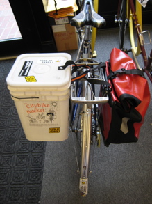
First off is a class to build your own panniers out of recycled buckets.

Cheap and fancy: Two Panniers
via Portland BTA
On Sunday, January 24th they'll be hosting a workshop to make your own hauling capacity. Waterproof hauling doesn't have to be expensive like the Ortlieb bag on the right. A recycled industrial, often food-grade bucket is a lot cheaper and just as good! You'll also be able to repair it more easily as it wears.

If you'd like to learn more, the class, which includes materials, is just $25. Registration is necessary, so see here for more.

Make your own panniers! January 24th at the Hub
Then, on Saturday, February 6th, they're hosting a bicycle safety fair.

Wednesday, January 13, 2016

Proposed Fairview Park Could Include Pump Track; Hillcrest to be Sold

The Fairview Park Planning Process continues apace, and they've got a new survey out. The Salem Area Trail Alliance has been urging folks to vote for a bike park to be included.

Concept 2 shows a pump track on the slope to Old Strong Road
The parcel has been subdivided into three areas, each having four different possible primary uses. Four different concept maps show all 12 options, and the options could be shuffled of course in just about any combination - I don't think any pairs are mutually exclusive.

The four candidates for the sloped area next to Old Strong Road (at top of picture) are: pump track, dog park, disc golf, and loop trail.

The repair station in Riverfront Park (2014)
With a pump track, a repair station and shelter might be nice also.

Tuesday, January 12, 2016

Fred Meyer Gas Station, Lord and Schryver Parking, Cherriots Funding at Legislature

At the Hearings Officer on Wednesday the 13th is the appeal on the gas station near Madrona and Commercial. (See previous discussion here and here.)

On the matters of the appeal itself, I suspect the Neighborhood Association making the appeal will have a difficult time. I don't see errors by City Staff - do you?

Within the framework of the existing regulations and process, the proposal seems licit and the outcome likely to affirm the Planning Administrator's decision.

But the framework itself has serious shortcomings.

At the highest level, the proposal amounts to demolishing existing mid-century cottage housing and a somewhat later office building and replacing them with a gas station.

That seems like it's a clear downgrade in land use, the kind of thing the regulatory environment should inhibit rather than allow or encourage.

The office building to be demolished in grey at arrow,
Clark Creek running underneath.
(Color juiced from City stream map for clarity)
It's also over a culverted creek that immediately runs through a City Park, and fuel and creeks seem like a very bad mix. Even with a "Stormwater Pollution Control Plan," which Public Works could require of the gas station, the baseline is an assumed level of pollution - which still might be unwise. It seems like we already have plenty of pollution from surface run-off with the parking lots and Commercial Street, and that risk of the concentrated kind of pollution from a fuel spill nearly directly into the creek and park is a classic "bad idea." Additionally, as we seek to transition the whole consumer and residential fleet to electric cars, why invest in gas now? Petroleum fuel just seems all wrong in this context.

Proposed Fred Meyer Gas Station Site, Possible Median, and
Commercial Vista Corridor Study proposals (June 8th Memo)
Finally, it's in an area slated for improved crosswalks and medians, and all the turning movements for entry and exit for a gas station seems like a move in the wrong direction for Commercial Street safety and attractiveness.

So just at the summary, policy level, this project seems like it is a failure on multiple grounds.

But it probably meets the letter of the law.

Monday, January 11, 2016

Before Jaywalking: Pedestrian Rights and a Dangerous Instrumentality in 1921

Looking south on Commercial from Court, 1913
This is googlebooks gold.

From the 1921 book, The Law of Automobiles, comes this great pre-jaywalking discussion of cars and people on foot.

It's seems very different.

The chapter on walking rings the central assumption:
Pedestrians and automobile drivers have, aside from statute or ordinance changing the rule, equal rights in the use of the public highways....

The person having the management of the automobile and the traveler on foot are both required to use such reasonable care as the circumstances of the case demand, and exercise of greater care on the part of each being required where there is an increase of danger.

The right of the plaintiff as a pedestrian to free and unobstructed passage also has not been abridged by modern conditions of travel. There is no law or principle of law, or of reason, which confines foot-passengers to particular crossings. Such a restriction would be very inconvenient and annoying. The street should be kept in such condition that foot-passengers may be able to cross, with a reasonable degree of safety, using proper care themselves, at any and all places.
The development of jaywalking laws in the 1920s changed all this.

Sunday, January 10, 2016

Climate Change and Bikes in Today's Paper

Just glancing through the paper this morning, it seemed like non-auto travel and climate change threaded their way through a relatively high number of stories. It was great to see these themes as matter-of-fact context and reporting rather than human interest and spectacle.

Maybe 2016 will be the year that these things really start going mainstream.

Ski resorts, changing businesses, and climate change.

In a USA TODAY article on "next-gen energy" the recommendation to walk, ride a bike, or take transit.

The struggle for clean air in China.

Friday, January 8, 2016

City Council, January 11th - Cueing up TSP Amendments and Police Station

Council meets on Monday, and we've already discussed the report on those struck and killed while walking. There's also a "future report" on proposed amendments to the Transportation System Plan for the 25th. Both it and the report on the Police Station for the work session on the 21st show planning and modeling that is escaping the bounds of known trends and best available information.

Unconstrained Modeling and Planning

The two matters of the Third Bridge and the Police Station appear to show a pattern: Modeling that is unconstrained by empirical data.

Interestingly, the draft amendments to the Transportation System Plan have been edited since they first came before the Planning Commission.

N3B pointed out that the Plan was being untethered from "anticipated revenue sources" and that the most likely reason for this was in order to smuggle into it the giant budget for the proposed Third Bridge and ancillary projects, which at present has no viable funding plan and does not constitute something with a reasonably anticipated revenue source or sources. It is unconstrained by reasonable expectations and empirical data.

December 2015 draft
This is being made more explicit in the latest draft.

January 2016 draft
So that's something to note.

Thursday, January 7, 2016

City Report on Walking Deaths a Little Heavy on Victim-Blaming

Back in August Councilor Andersen asked about the crashes that had killed several people on foot in 2015.

January 29th, 2015
investigating David McGregor's death
Public Works and the Police have now come back with a report to Council on Monday the 11th, and it is worth some extended comment.

From here is seems like there is too much blaming the victim in crashes, and not enough on ways that our whole system is designed to prioritize auto travel at the clear expense of those not in cars.

Grading congestion and delay for cars A through F:
Level of Service (LOS) only means service for those in cars;
it always seems to trump comfort and safety for those on foot
(detail from a different report - see below)
From the report:
The crashes resulted in four serious injuries and seven deaths. There were no common patterns or problems among the nine crashes, but several causes appeared more than once as contributing factors - intoxication, dark clothing, and poor/limited visibility. The following key factors were identified as significant contributors:
  • Intoxication in three of the nine crashes
  • Dark clothing worn by the victims in four of the nine crashes
  • Poor/limited visibility in four of the nine crashes
  • Violating regulations or poor decision making in four of the nine crashes (Specifically: an intoxicated driver driving into a marked work zone; a skateboarder running through a red light; a bicyclist (who was not wearing a helmet) making quick lane changes across two lanes of traffic; and an intoxicated pedestrian trying to cross five lanes of traffic 75 yards from the nearest crosswalk.)
Here's a more detailed summary of each crash from the report. Quoted text is in italics, comments are added between crashes in regular face. All color images added as well. (It is bothersome that no person is named: They are unnamed abstractions, "pedestrians," not individuals with a history and family and friends. But this is the current convention, a reflection of the system problem.)

Wednesday, January 6, 2016

Before it was Downtown Storage it was Larmer Storage - and a Hops Warehouse

You probably saw the article about the tour of proposed Police Station sites. SCV will have lots of commentary, so be sure to check that out.

Probably the most interesting site of the bunch is the old Larmer Transfer and Storage site.

The south building in 2010 - ghost signs! See the big L

Two warehouses on Liberty/Broadway
Aerial of the Larmer Storage block

Tuesday, January 5, 2016

On a Snow Day, Cherriots Gets too Little Love

Early Monday morning - no mention of Cherriots
It was interesting that the City's social media, several notes yesterday and today, conspicuously omitted transit as a commuting solution in snow and ice.
By contrast, Portland Bureau of Transportation plugs it strongly.

Even Portland's traffic engineer in charge of signals lauds it.
This is generalizing from a small sample, so it's not like it's a statistically valid inference or anything, but the difference in tone between a couple of public statements on transit is striking.

Even in the paper it's considerably more defensive in tone than Portland's celebration of transit. It's like the implied audience doesn't really know about Cherriots or believes buses are not safe.
As for commuters, [Cherriots GM Alan] Pollock had one piece of advice.

"We encourage people who are not comfortable driving in these conditions to give the buses a try," he said, stating that they are a safe way to get to work.
By itself, a greater awareness of Cherriots in our City social media won't necessarily change much, but as an indication of differences in deep civic culture and values, it says volumes: We treat transit as a fringe thing rather than a core form of urban mobility.