Friday, June 30, 2023

Tell ODOT to Think about Climate on Costly OR-22/OR-51 Proposals

ODOT's got a new online Open House and survey for their proposal for the interchange on Highway 22 at Highway 51, the road to Independence.

The multi-use path still looks like a second thought
(comments in red added)

If you accept the basic terms of the project, the design looks like the multiuse path remains very secondary, to be fitted in only after the car travel lanes are expanded and designed.

An early roundabout in Springfield, c.2006

Here's an early higher-speed multi-lane roundabout in Springfield. The crossing areas for walking and biking force a person to contend with zoomy drivers who may not be looking for crossing travel from non-auto traffic.

In the proposal for OR-22 and OR-51, the path looks to be designed for east-west travel on OR-22 only. If a person biking wanted to make a turn from OR-22 southbound onto OR-51, or was northbound on OR-51 and wanted to make a turn onto OR-22, they would have great trouble. The design does not appear to have any consideration for those turning movements.

But there are reasons to question the whole project, not just design details for non-auto travel.

Excerpt of 350.org letter

You may recall that our 350.org chapter rightly criticized the project as contrary to our State goals to reduce greenhouse gas emissions. ODOT's not looking at induced demand at all.

Wednesday, June 28, 2023

Salem's First Zoning Map Limns Familiar Neighborhoods

With the debate on the overlay zones, it was time to return to the history of our zoning. 

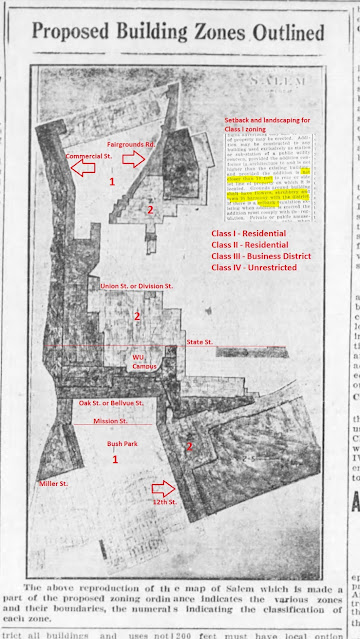
December 11th, 1926, red added

Though it may not be exactly the same map that was adopted, this is very close to the first zoning map for Salem. There was a Public Hearing two days later on December 13th, and the zoning ordinance adopted on December 20th, 1926.

In microfilm and then scanning, the map is blurry and hard to parse. Some street boundaries, and a couple of other big streets, are added in red, as well a couple of places and also some zone numbering for 1 and 2. Zones 3 and 4 are indistinguishable. Some of the boundaries might be alleys rather than the streets themselves, so there's still a bit of uncertainty there, and we might be able to revisit it and be more exact later. But you can still see the main outlines of things.

The better class of "Residential District" had setbacks and landscaping requirements.

These clips are from the afternoon paper, and when we looked at things earlier, the clips were from the morning paper. This time the focus is less on beauty and more on exclusion in the service of property value.

In the lead up to the map, it was interesting to see again prominent instances of the rhetoric of "promiscuity" and "segregation."

"Promiscuous building," January 5th, 1926

Tuesday, June 27, 2023

Salem Continues to Rank Poorly in Latest People for Bikes Rating

Ooof! The new People for Bikes "city ratings" are out, and Salem looks pretty bad.

With a numerical rating of 17/100, Salem is in the 35th percentile overall, and in the 28th percentile among mid-sized peer cities.

That's bad - People for Bikes

The combination of old school, paint-only lanes on busy streets and very few improved low-traffic bikeways together makes for a high-stress network.

We've hardly improved on the conditions the Sustainable Cities Initiative identified over a decade ago.

Anticipated "Level of Stress" analysis (2010/2011)

The current People for Bikes network analysis is substantially identical to this. The new streets at Fairview are the most substantial addition, though until any commercial hub is built, residents of Fairview remain pretty distant from destinations, and must go on zoomy stroads to reach meaningful places.

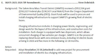
Voting Structure, Cost Escalation, Bus Charging: At the MPO

Expanding the Metropolitan Planning Organization this time and incorporating Ausmville into it looks to be a little tricky. The Policy Committee for our MPO meets today, and they'll be considering engaging some external services to facilitate and perhaps mediate the conversation.

I am not sure there is anything new to say at the moment on it, or other topics also, so this is just a brief, summary post.

"Enlist...a facilitator"?

And conversation on cost escalation continues.

$4 Million on McGilchrist possibly still in play

On both topics see earlier this month at the technical committee. It does not seem that either topic has advanced a great deal:

On EV mania

One item to watch is the infrastructure cost to run a small fleet of electric buses. Some transit professionals are advocating caution. If operating an electric bus cuts into frequency of service or to less coverage, it may be that the trade-off is not actually valuable.

Monday, June 26, 2023

In an apparent Hit-and-Run, Driver Killed Person along Chemawa Road

A little over a week ago in the night, a person driving a pickup struck and killed a person walking along Chemawa Road. They did not stop to render aid, and fled the crash. Police appear to be investigating it as a hit-and-run.

From Salem PD earlier in June and with an update today:

Salem Police officers have initiated a death investigation after a person was located deceased in the roadway just before 5:00 a.m. today, June 17.

Witnesses reported finding a deceased man in the road on Chemawa RD NE west of the intersection at Portland RD NE. The deceased individual is identified as 21-year-old Michael Scott Campos-Kegley.

The investigators are working all available leads, and no further details about this case are being released at this time.

Anyone with information about the incident is asked to call the Salem Police Tips Line at 503-588-8477.

Update 06/26/2023

An update from the Salem Police Traffic Team’s investigation into the death of Mr. Campos-Kegley reveals he was struck by a vehicle while traveling along Chewama RD just west of Portland RD NE in the early morning hours of June 17.

Investigators are searching for a 2018 Chevrolet Silverado which is missing the covering to its passenger-side mirror and has some damage to the passenger-side, headlight assembly. The color of the truck is unknown.

Investigators would appreciate hearing from anyone who may have seen the collision or has information about the case. Please call the Salem Police Traffic Team directly at 503-588-6293.

This post may be updated.

Housing, Livability, and Cars: Notes on Overlay Zones and Origin of Free Parking

The role of housing lurks in the background of two items at Council, the information report on downtown parking and the formal Hearing on repealing the overlay zones.

See recently here:

Here are some additional notes.

Back in August of 1977 free parking in our downtown parking district started.

August 7th, 1977

They were explicit about offering parking for shoppers: "The effort to provide more free parking in downtown Salem...is designed to offer customers the convenience of shopping malls...."

August 1st, 1977

In the lead up to it, the City's "renewal administrator," published a breathless opinion piece. "One can already feel the pulse quickening in downtown Salem...more interesting, stimulating, and just plain fun for people."

October 31st, 1976

It's all so autoist and suburban. There are essentially no residents and no homes in this conception. It's a drive-to destination for entertainment, shopping, and errands. It is not itself a neighborhood. It's for transitory amusement, for a kind of tourism. Downtown is a mall.

It exemplifies nation trends, of course, the flight from the inner city, although it's not really true to say Salem had an inner city.

An important ingredient in the hollowing out of downtown is the expansion of the Capitol Mall, of Willamette University, of the Civic Center, and of the Pringle Creek Urban Renewal Area. Families might voluntarily have moved out of those close-in neighborhoods, but our institutions and big redevelopment projects also displaced them. The loss of Piety Hill is our great image for this.

Thursday, June 22, 2023

City Council, June 26th - Sustainable Cities Initiative and Vision Zero

Holy smokes, Council has a ton of interesting items on the agenda for Monday. Some of them we've previewed a little this week already, and they'll be in a second post over the weekend.

Fascinating is the return of the Sustainable Cities Initiative this fall for the next school year

You may recall the project back in 2010-2011. We'll come back to think a little more about it later this summer.

One thing that immediately comes to mind is that the analytical mapping projects yielded more directly useful information than the more free-wheeling vision projects for entire neighborhoods.

One of the smaller projects was "Accurately Modeling Salem’s Bike Network in ArcGIS" by Michael Duncan, Kory Northrop, and Ted Sweeney.

The project modeled

bicycle routes along the parts of roadways where bicycles actually travel, and measures the level of fear associated with each section of the bicycle network. The dataset can be used to compare cycling routes through the city based on how scary they are, which can help guide infrastructure investment to increase the comfort levels of all bicyclists.

Anticipated "Level of Stress" analysis

This general concept is used now by transportation planning consultants, and the students were out in front of that a little bit. Their use of GIS technology seemed to be advanced relative to many professional traffic planners and engineers, and this might be an area for the City to ask SCI to lean into.

O'Brien analysis

By contrast, the ideas for the O'Brien parcel were abandoned with the Police Station, and related projects for Second Street in West Salem and the Epping parcel off Portland Road have not much corresponded to actual redevelopment.

Make Music Day adds Life to Downtown

Sometimes the Solstice weather for Make Music Day is not so inviting, but yesterday's was perfect: Sunny, but not hot.

There are plenty of galleries of the main performances spaces and people, so be sure to check them out.

A favorite, which I did not see in person, was this organ. Did you see it?!

via IG

Later, a loud Samba group paraded the sidewalks and alleys.

A mobile fest - via IG

You will have your own favorites.

Here are some other notes, more on things in the cracks between.

Wednesday, June 21, 2023

DAB starts Discussion of Parking Schedule, Previews Council Report

The Downtown Advisory Board meets tomorrow, Thursday the 22nd, and they've got a tentative schedule for more parking reform and a preview of an information report at Council on Monday the 26th.

A tentative schedule!

From the memo:

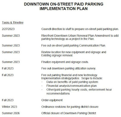
At the February 27, 2023, Council meeting, Mayor Hoy directed staff to return to Council with a plan to implement paid on-street parking in the downtown parking district and phase out the parking district tax.

At the June 26, 2023, City Council meeting, an information report will be shared with City Council outlining the on-street paid parking implementation plan that is outlined in this memo.

The Downtown Advisory Board has recommended converting the free parking district model to an on-street performance-based system of parking and elimination and/or phasing out the parking tax for several years. Ten years of downtown parking utilization studies have recommended replacement of the current Downtown Parking District model with a performance based on-street paid parking management system....

The timeline as you can see suggests it will take three years to implement. In the meantime Staff will also be recommending a reduction in the current free parking arrangement with a limit moving from three to two hours.

In order to manage the increased demand for on-street parking until such time as the on-street paid parking system is implemented, on-street time restrictions will need to be changed from three hours to two hours. Third party data collection results indicate the average on-street parking time limit is less than two hours and a change would increase available on-street parking options. [italics added]

The parking garages would remain free now, and remain free under a right-priced system.

Free parking promo - November 2020

There may be more to say in the Council preview here, as the information report to Council looks to have a little more detail - but also, the conversation might be exhausted, at least here, and there might not be more to say.

See previous notes here tagged "downtown parking."

Monday, June 19, 2023

Salem Bike Vision Announces Summer Slate of Rides

Over the weekend Salem Bike Vision advocates announced three summer rides.

via Twitter

Each ride is aimed at persons with different riding interests and skill levels.

The three rides via signup form

You may recall back in April when they announced a grant award from People for Bikes. People for Bikes said:

With this grant, Salem Bike Vision (SBV) will host three community rides in 2023, working to educate the public about what makes for effective bike infrastructure and helping identify areas where safety is lacking. The organization will also engage local decision-makers around opportunities to use the city’s recently passed bond for safe bike infrastructure.

These are clearly community rides. But if the goal was "working to educate the public about what makes for effective bike infrastructure and helping identify areas where safety is lacking," the target group for the first ride, "those who use their bike regularly and feel comfortable," likely needs no education on effective bike lanes or identifying dicey areas. This is preaching to the choir, and may be a bit of wasted opportunity.

Friday, June 16, 2023

Juneteenth History Walk to visit Church, Home, and Shop Sites of Albert and Mary Ann Bayless

Looking for a deep and meaningful cut of Black history and Salem history on Juneteenth? Together with Oregon Black Pioneers and Just Walk, the Mill's organized a three mile walk around Salem sites associated with Albert and Mary Ann Bayless.

History walk honoring Juneteenth

On the day of the walk they'll publish a map, so hopefully it will be possible to make walks independently later also.

They'll visit the Bayless house site in Piety Hill, churches the Bayless family helped fund and worshiped at, and one or more blacksmith shop sites. You may recall from the talk earlier this year that one of them was likely at the site of our new Police Station.

Early shop at site of Police Station

The walk will start from the Mill's parking lot, just north of the train depot, on Mill and 12th, at 10am on Monday, June 19th.

See previously here:

Addendum, Sunday the 18th

Here's the map!

Map of Bayless family sites

Thursday, June 15, 2023

Mixed-Use Project on Commercial and Bush Evidence to Ditch Complexity of Overlay Zones

Though it is a lesser detail on the whole, the setback on a side building for a proposed mixed-use project with 45 apartments and ground floor live-work studios is concrete evidence in favor of eliminating five overlay zones on Commercial Street.

Proposed building on Commercial and Bush Streets
(Side building under red arrow)

The main building, which would replace lot vacant for at least a decade, is in the new Mixed-use I zone on Commercial and Bush, and is outside of the Saginaw Overlay. Most of its details meet the rules and project does not require a Public Hearing. It requests a few adjustments, but they seem reasonable, and are subject to administrative approvals rather than the formal Public Hearing process at the Planning Commission.

Even though zero parking is required, there is still a modest parking lot proposed. With the live-work units, there are prospects for small retail or services at ground floor. This looks like the kind of thing the new mixed-use zoning was supposed to prompt!

The intersection of Commercial and Owens has potential also to be more of a neighborhood hub for Sleepy Hollow.

One adjustment to note involves the overlay. Part of the project is on a little extension of the Saginaw overlay zone, on the other site of the alley. Even though many of the immediate buildings are single detached houses, the zoning along Saginaw is for apartments. The project requests

A reduction to the minimum building setback adjacent to a street for the proposed single story office building within the Saginaw Street Overlay Zone from 30 feet to five feet which is consistent with the MU-I zone setback standard.

A small portion of the project in the overlay
(RM2 in brown, MU-I in purple)

30-foot or five-foot setback?

The five-foot setback, which would align with the main building, creates an important continuity across the alley.

The proposal to eliminate the additional layers of red tape constituted by these overlay zones will be at City Council on Monday the 26th. The City has published a comparison here. There will be more to say when the Staff Report comes out.

Here are a few brief notes also:

And on the history of the neighborhood:

Tuesday, June 13, 2023

Near Wheatland Road on Wallace Road/Highway 221, Driver Struck and Killed a Person Biking

Very near the Spring Valley Access and trail system on the Willamette Greenway, and just south of the intersection with Wheatland Road, a person in a truck has struck and killed a person biking on Highway 221/Wallace Road.

From State Police:

On Saturday, June 10, 2023, at approximately 11:28 A.M., the Oregon State Police responded to a vehicle versus bicycle crash on Hwy 221, near milepost 11.5, in Polk County.

The preliminary investigation indicated a silver 2021 Ford F-350, operated by Robert Weeks (47) of McMinnville, was traveling southbound on Hwy 221 when it passed a bicyclist, Adam Joy (55) of Portland, traveling in the same direction. The bicyclist fell over, into the lane of travel, just as the F-350 passed. Even though the F-350 had slowed when passing, the rider of the bicycle was run over by the F-350 and was pronounced deceased at the scene.

The operator of the Ford remained on scene and was cooperative with the investigation. [The time stamp was corrected by OSP from 1:28 to 11:28]

Today's paper

The paper uses the passive voice, erases the driver, and firms up "preliminary investigation indicated" translating it to "determined." It also has the wrong time. It shows bias.

Since Joy was a Vancouver middle school teacher and an experienced cyclist, BikePortland has written about it from a road biking perspective:

The roadway on this section of Wallace Rd is two standard lanes. There is little to no paved shoulder space beyond the two lanes. While this highway might look unsafe for cycling, that’s only because of how fast drivers go on it. The surrounding area is very popular for cycling with the bike paths in Spring Valley and the Willamette Valley Scenic Bikeway nearby (the latter being just on the other side of the Willamette River). The Wheatland Ferry — a fun way for bike riders to cross the Willamette River — is about two miles away and the Wallace Rd. section of the bikeway route is less than two miles from where Joy was hit.

I'm not sure what is the "Wallace Rd. section of the [Willamette Valley Scenic] bikeway route. I don't believe there is any Wallace Road section. But this is not an important detail.

I find Wallace Road stressful and uncomfortable to bike there, and I do not enjoy it. More committed road cyclists might not mind, but most people would. It is occasionally, however, a means to an end, part of travel to more pleasant places. It should be a better place to bike.

More significantly, BikePortland also discusses the matter of safe passing distance, and there are reasons to think the driver's exculpatory narrative deserves more scrutiny.

Update, September 21st

BikePortland with an update:

According to the Oregon State Police, the decision to not charge Weeks was made on August 22nd by Polk County District Attorney Aaron Felton. They say there was “insufficient evidence to support criminal prosecution.” While the DA and OSP felt the driver’s actions did not rise to the level needed for criminal penalties, they have issued Weeks two traffic citations: one for Careless Driving (ORS 811.135), and one for Unsafe Passing of a Person Operating a Bicycle (ORS 811.065).

Since Weeks’ careless driving led to the death of a “vulnerable roadway user,” (VRU) the citation triggers a stronger consequence. Bike advocates amended the careless driving law in 2007 for precisely this type of situation. Since the legal bar required for criminal penalties is so high, they sought to narrow the gap of consequences and bring more justice to families through the traffic citation. Violation of 811.135 with a VRU allows a court to require the driver to take a traffic safety course, perform up to 200 hours of community service, pay a fine of up to $12,500 and suspend their license for up to one year.

Update, January 25th, 2024

BikePortland published an important update today, "After reversal from DA, driver faces criminal charge for killing Adam Joy."

On December 19th, [driver Robert] Weeks was indicted by the Grand Jury of Polk County and now faces a charge of criminally negligent homicide....Weeks, a 47-year-old construction company owner, is scheduled to appear at the Polk County Courthouse in Dallas, Oregon on March 27th.

This post may be updated.

Monday, June 12, 2023

Thinking about Governance Structure and Cost Escalation: At the MPO

The technical committee for our Metropolitan Planning Organization meets on Tuesday the 13th, and there are a number of items to note in passing.

New website and home page

The Council of Governments, which hosts and staffs the MPO has a new website. It's optimized for mobile devices, and seems to load very slowly on a desktop. The first two things, finding the TAC meeting notice and the new location for the area bike map were easy enough, though. Maybe as we use it more there will be more to say.

On the meeting, as the MPO continues to grapple with cost escalation, centered on immediate needs for the Verda Lane project and then rippling out to other projects, a source of value engineering on the McGilchrist project may be in play. One of the proposals is to shave $4 million from the first phase, the intersection with 22nd. That may be of interest to critics of the McGilchrist project.

A way to shave funding for McGilchrist?

Other possible effects include pushing off the new sidewalk for Commercial Street SE between Vista and Ratcliff from 2026 out to 2028.

City Council, June 12th

Also at Council on Monday is a proposal for an employee payroll tax. Though the City slips in "unsheltered services," and some want to think that might mean funding for the Navigation Center or other services like that, the center of the list is Fire and Police, "community safety."

Probably it would be better to think of "unsheltered services" under "housing crisis" rather than "community safety." Some unsheltered people might commit crimes, but being unsheltered is not itself a crime or inherently a danger to the citizenry. This is a category mistake, welcomed and intended by some, but not something the City should embrace.

Additionally between recent reports on the frequency of Police shootings here, unnecessary and misdirected force used in policing protests, and the coverup going on with Marganne Allen's death, Council should be under no hurry to give Police additional resources until they figure it out.

Then there is the matter of Fire response, the proportion of calls that are medical rather than fire, and the best way to deliver services that corresponds to the actual call mix.

Others will have plenty to say and better things to say.

The airport is on the agenda for two items, creating a formal project to receive the last of the Fairivew Urban Renewal Area funds, and accepting a small amount of funding from Marion County. There does not seem to be anything useful to say on this folly any more.

Public Hearings on the two budgets, one for the City and one for the Urban Renewal Agency, are on the agenda. Hopefully others will drill into them and have comment.

Bullets:

Sunday, June 11, 2023

Is there a Heritage Tree on Union and Cottage? Checking in on the Union Street Bikeway

With the City announcement of construction starting on the Union Street Bikeway, and then an enthusiastic note over at Salem Bike Vision, it was time to check in on the venerable honeysuckle at Union and Cottage.

Honeysuckle at Union and Cottage

Honeysuckle in 2013

To this non-professional eye, it looked like construction was shaving the root zone awfully close. With signage and netting carelessly draped over it, it didn't exactly look like it was getting much special care.

Friday, June 9, 2023

A New Study for Front Street, Lingering Questions on McGilchrist

On Monday, acting as the Urban Renewal Agency, Council will consider a proposal for a new study on Front Street just north of the Union Street Bridge.

Imagining Front Street at Market Street

You will recall the recent excitement over the prospect of redeveloping the cannery site on Front at Market Street. (Previous notes here.) 

The City proposes to budget $250,000 in unallocated Urban Renewal funding for two studies, $150,000 for a new one on Front Street and $100,000 to update the grocery store study from 2018:

The Front Street multi-modal project encompasses the corridor that will link the Downtown area to the Cannery property project north of the URA. The corridor is impacted by the rail line, a potential trail, a pedestrian bridge over Mill Creek, and bicycle accommodation, which all need to be accounted for during the planning phase and before the developer finalizes plans. The grocery store update is to refresh data from the 2018 analysis in the Riverfront-Downtown URA given increased development completed and underway.

With the railroad, and the desires for housing and for substantial retail and recreation amenities, reconfiguring Front Street will be a challenge - but a worthy one!

That study will probably have a public process and hopefully direct conversation about trade-offs and different notions of balancing all the user types.

It is possible to imagine a lively district there in 2050.

By contrast, it is much harder to imagine a lively district along McGilchrist in 2050. 

This is one of the things that hampers discussion of McGilchrist. Certainly in the nearish term, say 2030 or 2033, even with terrific bike lanes and sidewalks, there is not going to be a high volume of people walking or rolling there, even with the brewery district, the Social Security office, and Veterans clinic. Non-auto travel will remain occasional rather than constant. So from that standpoint it may not be the best place for the City to focus on state-of-the-art bike lanes and sidewalks.

Further out, it's harder to imagine conditions on McGilchrist in 2050. Will robot trucks be the main user? Technological change may impact that area more than downtowns, where the basic act of something like eating in a restaurant remains tethered to the forms of our embodied existence.

But even granting that truck and auto traffic will remain primary on McGilchrist, speed remains a concern.

Over on FB, Commissioner Slater posted 15 theses from the meeting, representing the City position. Most of them seem broadly true and accurate, thought it is possible to quibble with some of them on smaller matters of degree and detail. But the whole seems driven by a tone of "Look at how much bigger it could be. Be thankful for the concessions we have already made." The lack of a public conversation about what we want from McGilchrist shows here.

I want to look more closely at two of the theses and to contest them a little, maybe more for future conversations and studies, for the "next time," rather than for McGilchrist itself:

  • The current professional understanding is that it is safer for bikes to cross intersections on the street, which is how this street is designed.
  • The engineer who did the design believes that speeds will average 30-35 mph.

Here is an enlarged detail from the plan at 22nd Street. (Comments in red and pink added.)

Eastbound on McGilchrist at 22nd
(red and pink comments added)

One concern is the set of ramps and transitions between the multi-use path and the short segment of on-street, paint-only bike lane at intersections.

Thursday, June 8, 2023

Decentering Samuel Thurston in Understanding the History of Oregon

The Oregon Historical Society announced the 2023 Joel Palmer Award for the best article published in the Quarterly over the previous year. This year a German historian from Leipzig, Julius Wilm, won for his article, "Old Myths, Turned on Their Heads: Settler Agency, Federal Authority, and the Colonization of Oregon."

Samuel Thurston
IOOF Pioneer Cemetery
Memorial Day weekend

It was particularly interesting for the critique of the way we have understood Samuel Thurston.

It took until September 1850 to pass the Donation Land Claim Act (DLCA) to legalize existing claims and offer land donations to incoming settlers. The delay deeply frustrated White Oregonians, and when the territory’s first non-voting congressional delegate Samuel R. Thurston departed for Washington, D.C., in the fall of 1849, lobbying for a land law was on the top of his agenda. Authors of later retellings — even those critical of the policy — have greatly exaggerated Thurston’s part in getting the law passed and his input in its framing, widely crediting him with authoring the law or being central to its passage. “Samuel Thurston wrote the Donation Land Act,” a web exhibition on the Oregon Constitution commissioned by the state archives states matter-of-factly. Authors of the classic pioneer-centered hagiography put Thurston on a pedestal as yet another settler-savior who through sheer willpower, as Whitman and Jason Lee had previously, forced reluctant politicians in the metropole to help the White frontier community that was on the verge of being forgotten. Authors of more-recent studies attribute to Thurston the most egregious features of the DLCA — its disregard of Native land rights and exclusion of Black settlers — thereby separating those features from their origin in imperial power politics.

This central importance that historians attribute to Thurston is based on an isolated reading of sources that are not understood in their context nor in their inherent contradictions....The exaggerated agency that authors of both hagiographic and critical history attributed to Thurston obfuscates the role of national political imperatives in developing the law.

2023 Joel Palmer Award winner

This looks like an interesting debate! Maybe Thurston was more of a cog in the wheel than we have supposed. If you are interested in the pre-Statehood, settlement period, and have not already read the article, it is available for free from the website (link at top). Check it out.

Monday, June 5, 2023

McGilchrist at the Planning Commission Tuesday

The Planning Commission meets tomorrow, Tuesday the 6th, and apart from the consent calendar, they have one item only on the agenda, an information presentation on the McGilchrist project.

the agenda item

I'm not sure there's very much new to say specifically about the project, though we'll review or repeat some points. 

More interesting might be how the project is currently situated at a number of different conversations and shows how the City is or is not addressing them or making progress on them.

Communications

Unfortunately there is no Staff Report, and the agenda item links only to the new "fact sheet" and to the project website. These are canned PR items, a bit of propaganda more than contributions to the debate, very much unilaterally conceived, being units of thought pushed out to the wider citizenry.

But on social media and elsewhere citizens have already raised a number of issues, and City Staff might have been more directly responsive to those comments and critique. Merely to repeat the "fact sheet" and project web page is largely to evade those questions and to assume a sympathetic audience at the Planning Commission. Hopefully in person Commissioners and the citizenry will have good questions. 

Like Councilor Stapleton has!

via FB
(The auto-generated caption is not the best)

There are more problems with communications. Back to the Commission agenda, the link in the agenda doesn't even work!

Busted link

The new City website does not seem to have a good architecture that is easy for Staff to use in updating and convenient for citizens to find information.

Thursday, June 1, 2023

Take ODOT Survey on Commercial/Liberty and Trade/Ferry State Highway Couplets

ODOT's got a weird survey out on the Liberty/Commercial and Trade/Ferry/Parkway couplets as part of State Highways 99E 

The street/highway segments

They say

We already have some planned projects on OR 99E and OR 22, and through this effort, we will identify specific bicycle and pedestrian improvements that may be added to them.

They show pictures of different crosswalks and bike lanes to illustrate possibilities, but they didn't choose particularly vivid ones. It's like they weren't trying very hard to illustrate concepts or to select images to get people excited about improvements for non-auto travel.

Then they start the survey. It's nearly all about crosswalks. The northmost section I rarely visit, and on that do not have opinions. (Frequent users/visitors of these streets will have important local knowledge, and hopefully they will comment most, as they will notice demand and need where less frequent visitors may not notice.)

The next section is right by Grocery Outlet, and a crosswalk at D Street has always seemed like it would be helpful. Interestingly, they do not show a circle on both Commercial and LIberty, but a crosswalk only on Commercial dead-ending in the median would be useless!

D Street needs a crosswalk!

Union Street is already getting crossing improvements, and because of the RR as a barrier, east-west walking travel along Center or Marion has not seemed high demand. Crossing at Chemeketa is, and it would be nice to see enhanced crossing facilities at Chemeketa, not just mid-block.