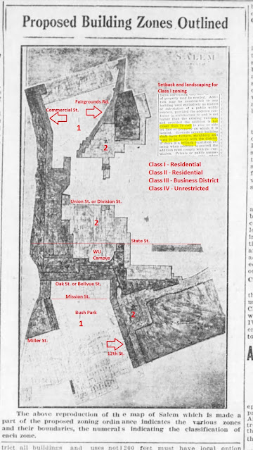
With the debate on the overlay zones, it was time to return to the history of our zoning.
 |
| December 11th, 1926, red added |
Though it may not be exactly the same map that was adopted, this is very close to the first zoning map for Salem. There was a Public Hearing two days later on December 13th, and the zoning ordinance adopted on December 20th, 1926.
In microfilm and then scanning, the map is blurry and hard to parse. Some street boundaries, and a couple of other big streets, are added in red, as well a couple of places and also some zone numbering for 1 and 2. Zones 3 and 4 are indistinguishable. Some of the boundaries might be alleys rather than the streets themselves, so there's still a bit of uncertainty there, and we might be able to revisit it and be more exact later. But you can still see the main outlines of things.
The better class of "Residential District" had setbacks and landscaping requirements.
These clips are from the afternoon paper, and when we looked at things earlier, the clips were from the morning paper. This time the focus is less on beauty and more on exclusion in the service of property value.
In the lead up to the map, it was interesting to see again prominent instances of the rhetoric of "promiscuity" and "segregation."
 |
| "Promiscuous building," January 5th, 1926 |
 |
| "Segregation," December 11th, 1926 |
The rhetoric of "encroachment" and "invasion" also appears in support for an assessment to fund the zoning and planning commission. It was framed as "insurance against unwarranted encroachment...which may seriously depreciate or even virtually confiscate the investment represented in your property."
 |
| Zoning as insurance, May 17th, 1926 |
Another editorial with the "insurance frame" called zoning "scientific management."
 |
| More on insurance, May 20th, 1926 |
It's all a very 1920s rhetoric, and maybe later we can look at some of the connections in more detail. But they shouldn't be very obscure!


No comments:
Post a Comment