The other day over on FB the Mill posted a neat image of the "Giles Packing House Girls."
 |
| via FB |
It led to a longer post about the H. S. Gile Packing House, part of the Willamette Valley Prune Growers Association.
A Sanborn map and footnote suggested it had been where the Vick Bros. building is today, currently part of the Salem campus for Western Oregon University.
 |
| With a Sanborn clip, flipped 180 degrees |
But the note also said "at the southwest corner of Trade and High Streets...." The Vick Bros. building is on the northeast corner. Something wasn't right!
It turned out that the map clip had got flipped and this flummoxed the writer. Orienting the text so it could be read placed north on the bottom of the map, and this non-conventional orientation suggested an errant location on the Vick Bros. corner. |
| 1927 Sanborn, note the compass rose and the upsidedown text |
Zooming out a pinch with conventional orientation shows the compass rose with north at top and the text all upside down. The confusion is easy to understand.
Here's the 1895 Sanborn for the same area (two page composite).
 |
| 1895 Sanborn (Library of Congress) |
You can see the intersection in a photo from c.1890, before the dome was added to the Capitol.
 |
| High and Trade, pre-1893 (Salem Library Historic Photos) |
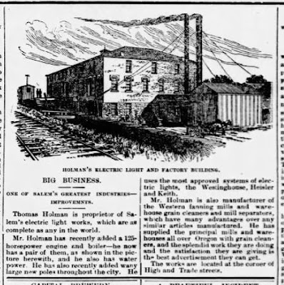
The large building on the southwest corner (upper right hand in pink on the 1895 map) was "Holman's Electric Light and Factory Building."
 |
| January 1st, 1891 |
On the 1895 Sanborn the building is labeled, "Churchill Sash and Door," "Western Fanning," "T. Holman, prop'r."
The building may have been sold to the Wallace interests.
 |
| December 23rd, 1898 |
 |
| Jan. 2nd, 1900 and Nov. 16th, 1901 |
 |
| March 31st, 1896 |
 |
| July 17th, 1900 |
This may be one of the buildings a little later.
 |
| January 1st, 1910 |
But it's all very confusing. The Willamette Valley Prune Association also had property on the southeast corner in addition to the southwest corner. You can see it in this four-block composite. Merely to say "the corner of High and Trade streets" doesn't identify which corner.
 |
| All four corners at Trade and High: Cherry City Flouring, Vick Bros., Willamette Valley Prune x2 (1927 Sanborn maps) |
There was a good bit of churn in this area. Different ownership groups with different names, lots of building additions and evolution without scraping a site and constructing a completely new building, and less documentation because it was the industrial area and not "pretty." You can also see the Oregon Electric line on Mill Street curving around for the run on High Street through the downtown core.
 |
| On Demolition: April 4th,1 1973 |
It had seemed like it might be possible in a summary way to consider properties on the 1927 map that had been demolished for the Pringle Creek Urban Renewal Area, but the churn made that difficult and it will require a closer look.
Today the site of the Holman Electric Light and Factory Building is the water feature and patio for Millrace Park, immediately north of the Pringle Parkade.
 |
| The four corners of Trade and High today |
All this is worth more attention, and maybe another time we'll return to it in more detail.


No comments:
Post a Comment