Though there are some big items, like the code update, which we'll get to in a moment, the most interesting item on Council agenda for Monday is another initiative proposed by Councilor Stapleton.
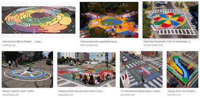 |
| Examples of "intersection murals" |
She proposes to "direct staff to create a proposal to establish a Street Mural program for Council’s consideration and adoption."
Over the past year or so I’ve been trying to find ways to elevate neighborhoods and bring a sense of community and beauty to the City. I believe that a Street Mural program, much like we see in other Oregon City’s, would be a wonderful addition to our neighborhoods. These works of art are designed, installed and maintained by the local community and bring a sense of pride and placemaking to an area. With these installations folks can easily express the culture and/or history of a place or highlight what makes their area of town a wonderful place to be. Beauty is not only for museums, parks or public buildings, it also belongs in the heart of our neighborhoods for all to enjoy.
See this Project for Public Spaces discussion from 2015 for more on the concept. Salem Reporter also has a piece about it, and compares this new proposal a little to the considerably more complicated process for murals on building walls. It says Belmont and Cottage in the Grant Neighborhood would likely be the first site for a street mural.
It is an interesting intersection. On one of the corners is the Roth House, associated with an earlier grocer named Roth (not the current one who just sold). Downtown the Roth building is incorporated into the McGilchrist building. The intersection also has had an empty lot on one of the corners. Though the Grant Neighborhood has opposed gentle upzoning and middle housing, this kind of place-making could calm traffic and also show demand for incremental increases housing and housing type.
In many ways this is a great idea and deserves strong consideration.
Related to Our Salem, and separate from the code amendments, there is a transportation related amendment to the criteria for a major, City-initiated comprehensive plan map amendment. It is in two agenda items, a Public Hearing, and a Second Reading for enactment.
The Salem Transportation System Plan, Street System Element, Policy 2.5, establishes the performance standards for operation and design of City streets. This includes the provision that the City shall allow its existing streets and intersections to function at a Level of Service (LOS) E, which is the LOS at which traffic volumes generally are approaching or at 100 percent of the street’s effective capacity.
The code amendment proposed in Ordinance Bill No. 17-21 establishes a threshold for when a major plan amendment would fail to meet this adopted performance standard. The Regional Travel Demand Model is a broad model of transportation performance and as such, has a lower level of precision than would be provided through a more detailed and focused traffic engineering analysis. To account for this and for the associated margin of error embodied in the Regional Travel Demand Model, code language is proposed to define when a transportation facility would fail to meet the defined performance standard as follows:
(ii) Determining significance. For the purposes of determining whether a proposed major plan map amendment will degrade the performance of an existing or planned transportation facility for OAR 660-012-0060(1)(c)(C) and (D), the following will not be considered significant:
- (aa) The plan map amendment increases average daily trips on a facility by fewer than 200 daily vehicle trips, or
- (bb) The calculated volume to capacity ratio with proposed plan amendment is within 0.03 of the volume to capacity ratio with existing plan map designations.
Working within the LOS paradigm, this seems like a reasonable adjustment.
But with the City considering a project to update to the Transportation System Plan for 2022-23 (these things always take longer!), there might be an opportunity to rethink the whole LOS paradigm, which counts cars instead of people, and transfers the analysis of mobility from the movement of people to the movement of sheet metal and engine. We are analyzing and modeling the wrong thing, especially if we want to reduce emissions and have more resilience.
This is also interesting as a tiny admission of margin of error in traffic modeling. I submit that even .03 is a wild assertion of unrealistic precision, either for the regional model or for "focused traffic engineering analysis."
 |
| Traffic modeling is full of false precision |
In one study of traffic modeling, the standard deviation of actual from forecast was over 20%. (This is count, not v/c ratio, so the comparison isn't exact, but for a discussion of margin of error, it's close enough.)
In the "Facts and Findings" for the large parcel directly east of the new Costco, at the Planning Commission next week, the City makes explicit how they understand the tolerance: "any v/c ratio that is calculated to be within 3/100ths of a percent (0.03) of the mobility target is deemed to comply with the target." 3/100ths of a percent vs. 20% is several orders of magnitude!
 |
| Year 2000 Forecasts circa 1980 vs. 2019 |
For example, in the circa 1980 study for the Front Street Bypass, consider the projected vs. actuals on Front, Commercial, and Liberty Streets: 54.2k/35.6k (-34%), 4.8k/12.3k (+156%), 5.8k/16.6k (+186%). These are all over the place, some higher, some lower than projections. And they are off by much larger factors than a fraction of a percent!
Our current use of traffic modeling and the LOS paradigm is so full of false precision. We need to ditch this autoism.
Previously see:
Council and staff dropped Peace Plaza for consideration for a pod of micro-shelters, and they have selected three of the sites for the next steps. They look to advance a proposal with
$200,000 of the State Sheltering grant for towing services, authorize use of the NW corner of Front St. and Hood St. NE property, 1280 Center St. NE, and 2410 Turner Rd. SE, for micro sheltering.
With the public comment period now closed, Council looks to make final decisions on the bundle of code amendments.
During that final comment period a few more comments came in and a few of those prompted further revision. The set regarding Fairview Refinement Plans appear to have been pulled entirely to be handled in a separate set of amendments, as there seemed to be complicating factors as well as the threat of an appeal to LUBA.
The cluster for tree conservation continues to attract critique from tree advocates and from developers, and that the bundle seems to be not quite satisfactory to both sides suggests that it might be a viable and effective compromise. In the final bundle, there was an interesting instance of horse-trading that will be very interesting as a trial.
In order for a tree conservation plan or tree conservation plan adjustment to be approved preserving less than the minimum required 30 percent, it must first, however, be demonstrated that there are no reasonable design alternatives that would enable a minimum of 30 percent of the trees to be preserved. In those situations where there are no reasonable design alternatives that would enable a minimum of 30 percent of the trees on the property to be preserved, any combination of one of the following mitigation measures would be required to be provided for each tree removed in excess of 70 percent:
- Residential density increase. One middle housing dwelling unit or accessory dwelling unit (ADU) provided for each tree removed;
- Solar power off-set. One solar array provided for each tree removed;
- Electric vehicle charging. One residential electric vehicle charging station for each tree removed;
- Open space lot. An open space lot reserved in the development that is planted with two trees for each tree removed.
That looks like an interesting experiment. Maybe it will work, maybe not, but it seems worth trying.
There's a cluster of letters from staff associated with a local
architecture firm, and they seem to be writing from a template.
Nonetheless, the comments are interesting. From one letter:
Table 806-9 changes the required bike parking to one stall per dwelling unit in the CSDP, which in larger developments can become an amount that can directly harm the amount of space for housing, or perhaps most importantly, open space that is desired in these code updates. As an avid bike rider, I fear my bike getting stolen if I leave it at a bike staple for longer than an hour or two, and when I lived in an apartment I opted to bring my bike inside for security. Multiple family living outside the CSDP seems to have a more modest bike parking requirement. I understand the intent of promoting multi-modal transportation in this denser area, but making it 10x the amount of other zones seems excessive. Maybe 2 or 3x as much?
The design standards shown in Section 524 inhibit the creative potential of the Front Street area. These standards depict a more historic design standard, and even contradict some of the examples shown in the section (for instance, neither of the precedent images in Figure 524-3 clearly show a horizontal change in color, material, or molding/transition piece) to designate the “bottom” from the “middle”). This may be one of the more exciting areas of Salem to be developed, and pigeonholing it to match the more historic character of downtown would be a giant mistake. This district should maintain flexible design standards in order to make it a unique and new area of Salem that can become a destination.
So for the project at the former Nordstrom site there will be 157 apartments, and that would require about 80 staple racks. They may have a point about jumping to this level of one per dwelling creating an oversupply at this moment. At the same time, we routinely oversupply car parking in large surface lots and oversupply street capacity by planning for rush hour maxima rather than normal use. At our present moment oversupplying for bicycle capacity seems like a small problem.
The point about the Front Street area design standards also seems worth noting, and perhaps dovetails with ways we misapply our Historic Preservation framework.
One the one hand the omnibus code package means that some helpful details will not get nitpicked to death; but on the other hand, some details may not get the debate and analysis they deserve.
Bullets for the rest:
- The annual Travel Salem report on tourism promotion.
- A small contract for arts tourism promotion
- It seems weird that Capitol Manor gets to use a pass-through on hospital bonds.
- And the annual financial audit for the City and a financial report for Urban Renewal Agency


2 comments:
What happened to the Salem Climate Action Plan? At the end of the agenda it doesn't even show up on the schedule for future public hearings. What is holding it up?
Over on the Tree Advocates FB page, they write in support of the tree code package:
"Updated Tree Ordinance Merits Support
City staff have updated the proposed tree ordinance draft to address concerns raised by the Home Builders Association. The changes do the following things:
(1) Require that builders provide solar, electric car stations, or other "green" features if they retain less than 30% of the existing trees.
(2) Establishes a criteria for circumstances when a developer may go below 30% of trees preserved.
(3) Allows a certified arborist to establsh a tree protection zone other than that set by the ordinance for nonsignficant trees.
The revised ordinance draft brings Douglas Fir back into the group of significant trees.
These are all reasonable changes to the proposed code amendment and the proposal as a whole merits passage."
Post a Comment