The City's published the recommendation for the big Bond Measure. Salem Reporter also has a summary and overview. Council has scheduled a formal Work Session to discuss it on May 16th, and there will be more to say then.
 |
| The allocation (from Budget Committee materials) |
At the moment, here's the streets and sidewalks portion in outline taken from the City's description. Comments here are in italics, regular script is quoted from the City summary.
If there is a theme here to the initial impression of the proposed bond, it is the lack of a big idea and total shape. The bond is a list of projects, a grab bag, and not something designed with a vision for climate or some other high value. What is the theme and narrative for the bond? The City calls it a "Community Improvement" bond. From here, that is vague and not super compelling. You might see the lack of a big idea, that it is not structured "top-down," as a feature rather than bug, however. It will be interesting to see what others have to say.
 |
| SF Chronicle (l) and Oregonian (r) this month |
But if this is the big bond for the next ten years, as we look back at it from 2032 or 2035, will we be happy with it? Will in 2035 the projects for "community improvement" seem bold, merely adequate, or badly underpowered? We have some important targets coming up in 2035.
Except for Marine Drive (below), the City doesn't list dollar amounts in the summary so we know the relative weight of investment without drilling into the spreadsheets buried in the subcommittee's meeting agenda. Dollar amounts here are rounded to the nearest half-million and taken from the spreadsheet in the April 4th meeting packet.
The City leads with a "bike/ped" list, but the three projects are mere fragments, small segments, not at all part of a great increase in total network connectivity. They are also awkwardly placed in the category.
Bicycle / Pedestrian Improvements (almost $20 million total)
- State Street
13th St NE to 17th St NE Bike Lanes and Pavement; Pavement
rehabilitation and striping reconfiguration to one travel lane in each
direction with a center turn lane and bike lanes. Includes a pedestrian
crossing at 15th Street and streetscape features. Also includes a new
traffic signal at the 17th Street intersection with NB and SB right turn
lanes on 17th Street. (About $14 million. If we assign the whole project to "bike/ped," that's really expensive for three blocks of connectivity! But of course there is a lot of car stuff in this also.)
- Pringle Creek Path - Civic Center to
Riverfront Park (half funding, anticipate grant for other half);
Construct a pedestrian bridge crossing of Pringle Creek under the
Commercial Street bridge, construct a new path along Pringle Creek from
Commercial Street under the existing railroad bridge to the Riverfront
Park. Includes creek overlooks and art wall. (About $3.5 million)
- Liberty Street NE
and Church Street Bridge NE railings - replacement concrete railings,
matching historic style at bridges over Pringle Creek. (About $2 million. Fixing the railings might be necessary, but this doesn't increase connectivity at all.)
The whole "Bicycle/Pedestrian" category is a little misleading. State Street is a 4/3 safety conversion, and it might be better categorized as an "Urban upgrade," along with McGilchrist, Fisher, and Pringle below. The bridge railings were originally a "Bridge Rehabilition" project but after April 4th got stuck in this "bike/ped" category. The Pringle Creek Path is really a Parks project. This category is not descriptive and doesn't work very well. It appears more for PR value, I think, so the City can say it has something big for walking and biking.
Sidewalk ($25 million total)
- Safer
Pedestrian Crossings to include median islands, lighting, rapid
flashing beacons (as needed), and new curb ramps and sidewalks to meet
ADA requirements. Locations TBD, after outreach and Council approval. ($7.5 million)
- Sidewalk
infill or construction of missing sidewalks for pedestrian
connectivity. Locations TBD, after outreach and Council approval. ($7.5 million)
- Sidewalk replacement of sidewalk panels that are failing. Locations TBD, after outreach and Council approval. ($10 million)
Pavement Repair and Rehabilitation. (About $23.5 million total) Fix up existing roadway, include curb ramps to meet ADA requirements at:
- Commercial Street SE: Fabry Rd SE to Interstate 5 Ramp and 12th St Cuttoff to Boone Rd SE (About $2.5 million each, $5 million total)
- Center Street NE: 17th St NE to 24th St NE (About $3.5 million)
- 12th Street SE: Mill St SE to Hoyt St SE (About $5 million)
- Silverton Road NE: 17th St NE to Williams Ave NE and Beacon St NE to Fisher Rd NE (About $5 million)
- Doaks Ferry Rd NW: Brush College Dr NW to Emerald Dr NW (About $1 million)
- Portland Road NE: Beach Ave NE to Northgate Ave NE (About $2 million)
- Liberty Street SE: Mill St SE to Trade St SE (About $0.5 million)
- Madrona Avenue SE: Peck Ave SE to Commercial St SE (About $1.5 million)
Most of the "repair and rehabilitation" projects, as well as other projects, include sidewalks, crosswalks, and bike lanes, but not all of them. Center Street, Silverton road, and Madrona (above) do not include bike lanes in the initial descriptions. We should not leave any large street without a bike lane now. Most medium streets rated collector, and all larger streets rated minor arterial or bigger are supposed to have them. Keeping some streets substandard is a real deficiency in the current concept, and the City should explain this. This is a clear sign of being oriented to the past rather than to the future.
 |
| Bond not connected enough with Our Salem |
Overall there is no commitment to the total bike network. The protected bike lane proposal of Councilor Stapleton and Cherriots President Davidson is not included, for example. And in looking at the whole list of projects, it does not appear to be conceived as anything to make a great difference in reducing driving and in overall mode split. It's improvement on the edges only (and some edges, like those on Center Street and Silverton Road, still won't get even old-school paint-only bike lanes). The way the "bike/ped" category was awkwardly filled with projects that better fit other categories is also evidence for this. In total the bond projects are about maintenance and keeping things the same, not about making significant changes to the way we get around.
Urban Upgrades. Includes new curb, sidewalks, multi-use path or bike lanes, stormwater treatment, and streetlights - with pedestrian crossings (About $61 million total)
- McGilchrist
Street SE: 12th St SE to 25th St SE (includes realignment and a new
traffic signal at 22nd Street, upgrades to two creek crossings, and rail
crossing improvements.) (About $14 million)
- Fisher Road NE: Silverton Rd NE /
East-West Curve (includes a traffic signal replacement at Sunnyview Road
and pedestrian crossings at Beverly Avenue and Devonshire Avenue) (About $28 million)
- Pringle Road SE: McGilchrist St SE to Georgia St SE (includes four pedestrian crossings near transit stops) (About $19 million)
 |
| McGilchrist in the draft 2023 CIP |
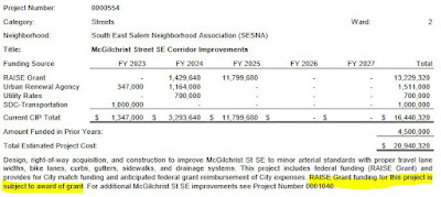
Interestingly, the City is still showing a Federal TIGER/BUILD/RAISE grant on McGilchrist in the draft 2023 CIP. If they are going to include it in the bond, they should definitely take the RAISE grant out of the CIP. More generally, the City should not include speculative funding sources in the CIP.
New Street: Marine Drive NW
- This first part of Marine Drive will go from Harritt Drive to Taybin and include a new multi-use pedestrian path connected to Wallace Marine Park. There will be a new road at a 'collector street standard' with two travel lanes, including new curb, a sidewalk on the westerly side, 12' multi-use path on the easterly side, stormwater treatment, and streetlights. Includes connector streets at Harritt Drive, Beckett Street, and 5th Avenue. This estimated to be $23 million of the $157 million for transportation in the current bond package.
Bridge Rehabilitation. (About $3.5 million total) Strengthen existing bridge to remove load restriction at:
- Liberty Street NE Bridge over Mill Creek (About $0.5 million)
- 17th Street NE Bridge over Mill Creek (About $1 million)
- Mission Street SE Bridge over Pringle Creek (About $1 million)
- 15th Street NE Bridge over Mill Creek (About $1 million)
Again, as the Council Work Session on the 16th approaches, there will be more discussion and analysis from the City, more reaction and comment by citizens, and there will be more to say. Maybe it will have snapped into focus by then, or we will find better ways to grasp and explain the whole and its parts.
 |
| From the November 2021 "accepted" final draft (comments added) |
But at first glance it just does not seem very responsive to our climate needs, and in 2035 we may look back and see a great missed opportunity.
Addendum, May 1st
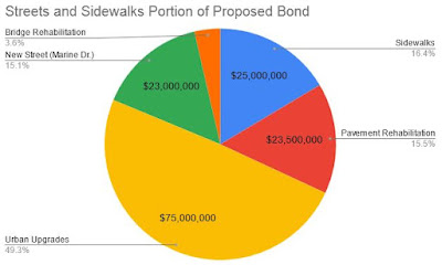
Here is a revised pie chart for the Streets and Sidewalks section. I have eliminated the "Bike/Ped" category and reassigned State Street to "Urban Upgrade"; the Liberty and Church Street railings to "Bridge Rehabilitation"; and the Pringle Creek Path off-chart to "Parks." This gives a better picture of the actual transportation allocation. (I also lost 1%, about $1.5 million, in rounding, but for the purpose here of relative proportions that doesn't matter.)
 |
| Streets and sidewalks categories (revised) |
Urban Upgrades and Marine Drive take about 2/3 of the total. True repair and rehabilitation are only about 1/3 of the total.
The Urban Upgrade projects deserve a closer look. Consider a completed project, Market Street near Swegle School. That went from two car travel lanes to two through lanes and a continuous center turn pocket. That's widening and 1/3 more asphalt. It's not clear why we always need to add that center turn pocket. The Market Street segment looks very overbuilt.
 |
| Older two lane cross section (by streetmix) |
 |
| Current urban standard (by streetmix) |


2 comments:
Added a second pie chart, a couple of street cross-sections, and comments about the allocation.
I agree that this bond proposal is a hodgepodge mess. I do not think it will pass. It needs a theme. Or it needs to be divided up and clarified as to goal.
I read a lot of questions and dissent. I'd like to see something to address homeless should be much stronger and to preserve our infrastructure.
Future fire station property has no appeal. Even equipment, which is needed, seems to have no appeal to voters.
This will be a lost opportunity.
Post a Comment