The technical committee for our Metropolitan Planning Organization meets on Tuesday the 12th. They have information on a segment of Commercial Street, some interesting survey results, and bits on the approach to congestion and project scoring.
TIP Amendment
One of the items in the meeting packet is a TIP amendment.
 |
| Start of multi-use path along new UGM facility New Police Station in background (at D and Commercial, 2021) |
Alas, the TIP amendment is really only a formality and a bit of a Potemkin instance of public process. The Staff introduction says, "This is considered a full amendment because it is adding mile points on a new section of roadway." But otherwise it doesn't really meet the spirit of a substantive amendment. It's hard to imagine any amount of public comment that might cause the project to change.
As you can see at top, the City already required a multi-use path as part of the new UGM redevelopment between D and Division along Commercial Street. (See also "City Fails to Solve Charlie Foxtrot, Uses Kludge at Front-Division-Commercial Intersection.") In the amended project there is no real opportunity for a new bike lane or a new configuration. There's not a decision point with options on which the public might comment or show a preference.
Earlier, the City and ODOT made plans and deliberately did not solicit comment before the project was baked and constructed. This non-process contrasts with something like the State Street Corridor Study, during which people were given ample opportunity to object to bike lanes, over and over. |
| No biking on sidewalk |
And now with this new multi-use path segment we invite sidewalk biking at a location where just two blocks south of it, we expressly prohibit sidewalk biking downtown. It's bad mixed messaging.
The sidewalk in front of UGM is also often clogged with clients of the shelter smoking, wandering, or just congregating. It is not a good bikeway.
In so many ways this is a bad design.
 |
| Hard to read. (blue=add, red=???) |
In the meeting packet is a sketch of the project area and description. It offers no more clarity.
When the Union Gospel Mission development came through the City, they required the sidewalk in front of the development from D St to Front St to be a multi-use path and connected the bicycle path to the Front & Commercial St intersection improvements triggered by the Police station development (2019/2020 construction). This changed the needed ARTS project bicycle path accommodations between Union St and Front St & Commercial St and freed up some of the funding we originally estimated and included in the STIP for this project for similar work the developments have since implemented. This means we have the opportunity to expand the bicycle path enhancement features on Commercial St AND add in Front St to Union St into our project as well (limited to pavement markings and signing for the Front St portion).
This clarifies little. It might sound good, like "bicycle path enhancement," but it's impossible to understand what is actually going on here. And the overall design is clearly enhancement for cars, with any bike lane and sidewalk very secondary.
The moment for public comment, and a genuine possibility to influence project design, was much earlier in the process. But the City and ODOT chose not to solicit comment on any of the street changes on Commercial related to the UGM or Police buildings.
It was a real missed opportunity.
MTP Survey
And they should want genuine comment. Also in the meeting packet is a summary of a survey for the MTP, the "long-range" plan.
Safety and comfort for non-auto travel leads the way! These lead "congestion" and "road conditions."
 |
| "Unsafe walking" and "unsafe biking" |
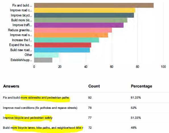 |
| More sidewalks, bike lanes, safety |
Congestion Management Plan
But our mania for congestion relief runs interference.
In the packet is a draft of the Congestion Management Process plan, a Federal mandate, and its corridors of interest overlap a lot with the protected bike lane concept of Councilor Stapleton and Cherriots President Davidson. In so many ways we need to accept motor vehicle congestion in order to reduce emissions from driving and to slow urban speeds for better safety. We need to start making different trade-offs if we are going to hit our emissions and safety targets. We need less driving, not more road capacity and higher speed driving under free-flow conditions.
 |
| Looks a lot like the bike lane proposal |
But the Federal framework for clean air does not include carbon pollution yet, and also is more interested in reducing idling and slowing than in reducing driving itself.
 |
| So much incoherence here (yellow in original) |
Just for reference, the official list of strategies is helpful. The whole RC category, "roadway capacity," is one that needs increased scrutiny, critique, and modification or just outright deletion. Pricing is listed separately as a potential strategy, but we don't employ it yet, so it's not in the table.
 |
| Official list of strategies |
Unused strategies, including pricing, are listed in an appendix.
 |
| For possible use later |
As an agenda item separate from the Congestion Management Process plan but nonetheless wholly related to it, the committee will hear about getting access to a newish source of mobile phone (and internet of things) traffic surveillance data and analysis.
RITIS (Regional Integrated Transportation Information System) is an analysis platform developed by the CATT (Center for Advanced Transportation Technology) Lab at the University of Maryland. The Oregon Department of Transportation (ODOT) purchased a license to use RITIS along with travel time data from INRIX (a third-party provider) covering the years 2016 to 2030. ODOT included access to RITIS for staff from local jurisdictions in the contract. The types of analysis available are outlined in the attached memorandum and will be shown in a brief demonstration at the meeting.
There a huge methodological problem with the INRIX data and likely with the broader RITIS framework: They measure delay from a "free flow" state; consequently, if traffic is traveling at the lawful speed limit on a road or corridor, in nearly all cases significantly below the free flow speed, the lawful speed counts as "delayed" and an instance of "congestion." Only streets with rampant speeding are not considered full of delay. Streets functioning as intended are already defined as congested and defective, requiring intervention or relief. This is messed up.
While RITIS is just a tool, it is one that has a very great structural bias. See previous notes:
- "Another Congestion Story Misses on Carbon, Crashes, and Compliance" (2015)
- "SKATS Considers Annual Work Plan, Still Struggles with Climate" (2020)
TIP Scoring
 |
| Preliminary rankings |
After a preliminary scoring, Salem's McGilchrist project ranked at the top, and three Cherriots requests as well as the County's requests for south River Road anti-truck stuckage and a north River Road study at Brooklake scored at the bottom.
The TAC will make a recommendation for sending five projects to ODOT for more detailed scoping. (The Staff Recommendation is for those projects with blue cels highlighted in the left hand column. The projects for completion funding are already scoped and exempted.)
See previously on the application and scoring process:
- "Pre-Apps for the 2024-2029 Cycle at the MPO" (December)
- "Initial Ranking of Pre-Apps for the 2024-2029 Cycle" (January)
- "City Includes Protected Bike Lane on Latest McGilchrist Proposal" (March)
The TAC zooms Tuesday the 12th at 1:30pm. The agenda, packet, and meeting information can be downloaded here.


3 comments:
You write: ' They measure delay from a "free flow" state; consequently, if traffic is traveling at the lawful speed limit on a road or corridor, in nearly all cases significantly below the free flow speed, the lawful speed counts as "delayed" and an instance of "congestion." '
Actually in the April 5 update for RITIS (so after the memo was written and sent out), the option to use posted speed limits for travel time index and planning time index has been added. Previously we've submitted the posted speed limits so we'll be able to report TTI and PTI using either (or both) method going forward.
Ray
MWVCOG/SKATS
Hey, that sounds like helpful progress! Thanks for the update. (But the "option" for posted speed should be the default!)
They should have removed some lanes and put in a roundabout.
Post a Comment