Back in January Councilor Stapleton initiated a process for street art and intersection murals. On Monday Council will consider the next steps with some revised code and a Public Hearing.
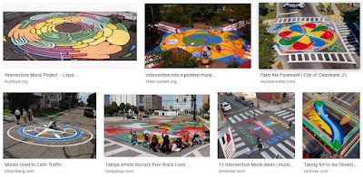 |
| Examples of "intersection murals" |
The package at Council has a couple of other elements tucked into it. It seeks
to create an approval process for “Street Paintings” in Salem, to provide an exemption for temporary banners regulated by a City-issued permit, and to provide an exemption for City-authorized signs in the public right-of-way....
the amendments addressing City-authorized signs in the public right-of-way will allow for the replacement of the Salem welcome sign on Portland Road NE, as requested by Northgate Neighborhood Association. The sign code does not currently provide an exemption for placing signs in the right-of-way and the welcome sign, and similar signs, are unable to meet the standards in the sign code, which are designed to address signs on private property. [link added]
It is a little amusing that the current "welcome sign" is non-compliant.
The rules have a lot of red tape, and also resolve a considerable discretion onto one person, named "the Director," who I assume is the Director of Public Works:
Street paintings as defined in SRC 15.010 are allowed in the city, subject to rules and requirements as determined by the Director. The Director shall promulgate rules to administer the time, place, and manner that street paintings may be placed on streets within the city.
Hopefully we can get at least one rolled out this summer and can start assessing and iterating, with luck to loosen some of the red tape and make them easier to create.
 |
| Neighborhood solutions |
Perhaps related to this, one of the brand-new projects in the Capital Improvement Plan the Budget Committee just looked at a little over a week ago is titled "Neighborhood Solutions," described as funding for things "to preserve and enhance neighborhood livability and safety....funds will be sued to construct engineering measures that address vehicle speed and volume." These could be the speed humps Councilor Gonzales proposed or this street art. It will be interesting to learn more about this.
 |
| Revised concept plan (yellow added) |
Immediately east of the new Costco, the proposed Kuebler Village development has a Public Hearing for the appeal of the Planning Commission's approval.
The latest plan shows the southeast quadrant zoned as MU-II, with a concept plan for two three-story mixed use buildings (in pale yellow), two four-story mixed use buildings (also pale yellow), two large parking garages (dark grey), one three-story apartment building (pale periwinkle), and one three-story medical office (light brown).
The rest of it, zoned CR, has concepts for retail, grocery, bank, fast food, hotel, restaurant, and medical office, as well as lots of surface parking. The Planning Commission allowed no more than three drive-thrus.
The Staff Recommendation is for denial:
Staff does not believe the applicant has met their burden of proof addressing the decision criteria, specifically that the transportation system will not be degraded with the proposed Comprehensive Plan Change and Zone Change for Comprehensive Plan Change and Zone Change to 14.55 acres of Commercial designation with Commercial Retail (CR) zoning and 9.8 acres of Mixed-Use designation with Mixed-Use II (MU-II) zoning.
They also highlight an analytical problem:
The applicant’s TIA shows that the intersection of Kuebler Boulevard and Battle Creek Road will have an increase in delay (from 77.6 second to 91.0 second) and have a Level of Service (LOS) from ‘E’ to ‘F’ between their project impacts and impacts after their proposed mitigation. However, they show the Volume-to Capacity (v/c) decrease from 1.58 after project to 1.14 after mitigation. The inconsistency raises concerns on whether the applicant meets the decision criteria.
There are several other interesting details. The developer would prefer to use a forthcoming Mixed-Use III zoning, but since we are not yet finished with Our Salem, that doesn't exist officially yet. They also say that if they don't get consent from the neighborhood association for the MU-II, they will revert to an older proposal for only CR zoning, and ditch the MU-II component. The maneuvering is a little complicated.
If we had a stronger Climate Plan, we could also assess the project on induced driving and increase emissions.
This set of four quadrants around 27th and Kuebler, anchored by Costco, is just heading in totally the wrong direction, a suburban model based fundamentally on regional driving trips and the proximity to the I-5/Kuebler interchange, in many ways inimical to walking, biking, and even busing. It's all about longer driving trips.
The project also has its own City web page. Previous notes here: "Another Contested Development Proposal at 27th and Kuebler" and "Losing our Way on Climate: Casino and Kuebler Village Move Forward.
 |
| Dreams of a beltline, 1984 (Year 2000 plan) |
Separately, the way that this area around Kuebler is being developed really should give us pause and suggest great skepticism about more general dreams of a beltline and widening efforts, including the current Cordon/Kuebler Corridor Study. The big parkway width and speed for a beltline will induce big, autoist development, those "regional industrial and commercial centers," and will explode the urban growth boundary. If we want less driving and fewer emissions, this is not the path for us. (See notes here on a beltline concept for a river bridge [2018], and a Council note on the corridor study [2021].)
Bullets for the rest, a bunch of final orders:
- Council affirms the approval for apartments at the former Bone parcel for the Titan Hill project on Doaks Ferry. (A note about this from December.)
- Council affirms the approval for the single detached housing at Robins Lane. (See this Salem Reporter story for more.)
- After it was pulled from the last meeting, the approval for Meyer Farm is back on the agenda. (All notes here.)
- And affirming the denial on the former Mushroom Plant. (Previous note here.)


No comments:
Post a Comment