A reader from our 350org chapter wrote to suggest that the project for OR-22 and OR-51, which has been holding an online Open House this month, was worth more notice.
 |
| 4 possible sets of roundabouts and ramps |
In particular, they suggested ODOT was wildly missing on the spirit and intent for reductions in emissions and VMT.
They are right!
The project already has experienced mission creep. Separate projects were consolidated:
- Realign connection with Doaks Ferry Road
- Reroute Riggs Street
- Close driveways on OR-22
- Improve safety for corridor, especially intersection of OR-22 and OR-51
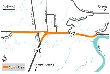 |
| Project area |
So now ODOT proposes an overengineered serving of spaghetti:
- An expansion of Riggs Street through the old Eola/Cincinnati
- Frontage/access roads
- Multiple ramps to OR-51
- Grade separated crossing, with OR-51 on a bridge above OR-22
 |
| One version of the total concept |
ODOT identified four different ramp and roundabout concepts (image at top).
At the moment it does not seem useful to try to select one of those as best or to spend any time trying to differentiate among them. They all center flow, speed, and throughput.
As our 350org chapter says,
The proposed interchange at Highway 51 and 22 should be rejected because it is too expensive and will induce additional travel and greenhouse gas emissions and because much more affordable actions that can improve traffic safety in this corridor can be implemented much more quickly.
A new interchange will induce additional travel and commuting from Independence to Salem that will increase rather than reduce vehicle miles traveled (VMT) and greenhouse gas emissions contrary to state goals and Executive Order 20-041 which directs state agencies, including ODOT, to do everything within their authority to take actions to meet GHG reduction objectives. To comply with this executive order, ODOT should reconsider the need for this project and consider and select an affordable solution that improves safety that is consistent with meeting GHG reduction goals.
They highlight cost. The interchange will be expensive. But also one of the reasons the Doaks Ferry part of the project was delayed was because of a previously unknown "ancient" landslide and associated unstable soils. On a smaller scale this promises overruns like those of the Highway 20 Pioneer Mountain to Eddyville bypass completed last decade, "Oregon Finishes Road Replacement 10 Years Later, $220 Million Over Budget," as OPB noted.
The whole project is positioned for large overruns.
Generally, there is no evidence that ODOT has used any of the tools generated by the "least cost planning" analytical process, which they had touted a decade ago. I believe the current instance is called Mosiac, though this is now nearly a decade old:
Mosaic is Oregon’s version of least cost planning. In its direction to ODOT, the Oregon Legislature defined least cost planning as: "a process of comparing direct and indirect costs of demand and supply options to meet transportation goals, policies or both, where the intent of the process is to identify the most cost-effective mix of options."
Mosaic has been developed in an effort to meet that definition. At this time Mosaic is focused at the planning level: sets or bundles of possible transportation actions or investments, and is not intended to analyze individual projects. The project stakeholder committee made this decision because a planning-level analysis allows for the inclusion of many different types of solutions including Transportation Demand Management, alternate modes, and others. In the future, Mosaic may be adapted for use at the project level. [italics added]
ODOT might say this is too small, too much an "individual project," yet the spirit of least cost planning should more fully animate the planning process here. ODOT has had time to let the concepts filter through multiple layers of analysis and planning now. It should be ready for "the project level" now.
 |
| 1975 Oregon Footpaths and Bikeways Progress Report |
Finally, the vintage sidepath along OR-22, one of the first to be constructed under our Bike Bill in the early 1970s, is nowhere discussed. The on/off ramps associated with OR-51 and the access roads, all appear to be formulated as if that path did not exist. The current process clearly envisions any bike lane as a very secondary layer to be fitted in later. But it should instead be centered as an opportunity for an improved bike facility that actually induces new bike travel, especially in the summer time.
Altogether the current state of the OR-22 and OR-51 Rickreall Road to Doaks Ferry Road project is misguided and unwisely supersized.
There will likely be more to say later.


1 comment:
The project is wildly over designed and the problem is a result of ODOT’s, and Polk and Marion Counties failures.
Highway 22 should have remained two lanes with limited access. Narrowing it will reconnect West Salem with the River. There can be passing lanes where appropriate. They should never have allowed the gas station that close to the 22 on ramp off of 51. A lot of the development shouldn’t have been allowed
The speed limit shouldn’t go above 35 until west of the U-Haul facility and not rise to 55 until after the 22/51 intersection.
There should also be a BRT connection between Dallas and Salem.
Post a Comment