 |
| New footbridge across Amazon Creek at Buck Street (Yeah, that's a paceline in the background on the Fern Ridge path) |
 |
| It was the top ranked bike/ped project: Eugene's bridges connect streets and bike paths to transit |
The bridge project hit some kind of magic multi-modal trifecta, scored very highly, and secured funding easily.
Two of the three bridges are now complete, and this summer construction is proceeding on the third and final bridge.
Apart from the strip along West 11th Avenue, the area is not all highly developed, and there is lots of open, undeveloped land in addition to that land specifically designated for parkland. Bridges that cross Amazon Creek are infrequently spaced for foot or bike travel, and are generally on arterial-type busy streets. So the footbridge connections meet a real need, and are also oriented towards future development. Already some large apartment complexes are going in, and between the bridges, path system, and bus rapid transit, it will be possible to get many places without a car - though the big parking lots, busy streets, pockets of void and empty space, and sprawly development patterns in general will still curb walking and biking from reaching full potential. There's an important land-use shift that will need to happen in addition to the transportation connections.
 |
| The Fern Ridge Path at Buck St looking north 11th Ave and KFC in background |
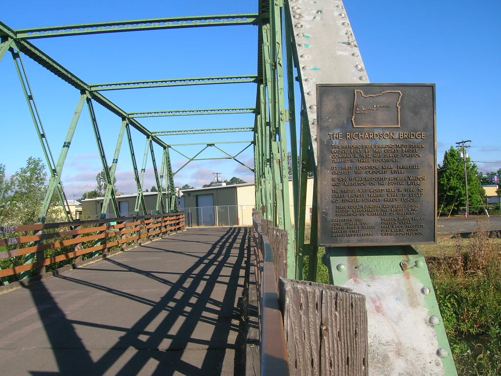 |
| Richardson Bridge of 1912 |
This historic steel diamond truss design bridge, built by the Coast Bridge Company in 1912, has served Oregon traffic in three locations.Very near the Wallis Street bridge, there is a direct connection between the Fern Ridge path and an EMX station, the Sam Reynolds* stop.
Its first location, near Prineville crossed the Crooked River.
In 1956 it was relocated between Walton and Mapleton on the Siuslaw River.
The bridge was moved here in 1986 to carry bicycle traffic when it could no longer support heavy loads.
 |
| Fern Ridge path, weeds, Sam Reynolds EMX station on W. 11th (The direct path connection in concrete is just off the image!) |
 |
| "Bus Only" dedicated right-of-way in concrete for EMX |
 |
| Traffic on West 11th includes heavy trucks and freight Pedestrian refuge and median with two-phase crosswalk |
 |
| Before: The same site in 2015 - via Streetview |
 |
| One of many undercrossings - here at Danebo |
 |
| Fern Ridge Trail in Blue, about six miles long - via Google |
 |
| Approximate same area - Eugene zoning map |
Back to Salem
Ultimately, these three new bridges in Eugene have a very different purpose than the Minto Bridge, so the comparison isn't always a strong one. There is no meaningful bike-walk-bus connection made possible by the Minto Bridge, and the reaches of the park are too distant from housing to make a new connection to downtown Salem.
By contrast, the Eugene bridges represent a serious approach to creating a useful walk-bike-bus nexus. You may have noticed that while 11th Avenue was widened for the outer bus lanes, no additional capacity for car trips was created. It's a total approach to mobility and to future growth in West Eugene that is not about the autoist primacy of drive-alone trips.
 |
| Puffery with no relation to reality |
 |
| It's a highway bridge, for highway speeds and dust not for pleasant walking or biking |
Mostly we harness and grand rhetoric to the service of selling projects we already want for other reasons. Too often it's a form of greenwashing.
 |
| Proposal for Core Network, July 2017 (list of corridors added to graphic) |
That would mean a much greater financial commitment to things other than road expansion for auto capacity.
Westside EMX is a $100 million project, with about three-quarters of that from the Federal government.
That's still at least one-fifth, more likely one-tenth, of the cost of a giant new bridge and highway.
 |
| Detail of Alternative 2A, from the DEIS, Chapter 2 |
Look, if you insist on the "freedom" to drive alone (or to use your new-fangled robot car), you will wait in line, paying in congestion and in time and in parking. But if you want to travel faster, take the bus! And you won't have to pay for parking. It's your choice!
* About Reynolds, Eugene Weekly says in a timeline on race and politics, in 1943 "another black family, the Reynolds (the namesake of Sam Reynolds Street), arrive. Along with the Johnsons and the Mims, they become the "pioneer" black families in Eugene, establishing themselves in the local lumber industry and founding several local black churches." There is more in the obituary for Sam's wife, Mattie Reynolds. See a previous note on the Mims House.


2 comments:
Done.
"N3B has consistently advocated for Alternative 2A, and if the current UGB and TSP decision is remanded by LUBA back to the City, . . ."
Eugene just dedicated a new historical marker -
http://www.registerguard.com/news/20180531/new-marker-honors-one-of-eugenes-founding-black-families
"On Thursday, about 50 people, including Parker and more than a dozen members of the Reynolds family, attended the dedication of a marker honoring the couple at the EmX stop on West 11th Avenue near Bertelsen Road. The stop is named for Sam Reynolds."
Post a Comment