 |
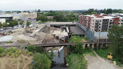
| View of Pringle Creek/Boise slab demolition (August 14th) |
We are also exploring potential pathway connections to Riverfront Park and Minto Island Pedestrian Bridge through this area.But they've been saying that for a long time. A path connection has been in the last position after the other elements of the Boise project were redeveloped - the apartments, then the office building, and finally the nursing home, which hasn't broken ground yet - and constructed; it should have been first, really.
The railroad has also been a problem. They have not been keen on even a grade-separated crossing or tunnel under the trestle. This is a concrete example of the way railroads create barriers and make it difficult for cities and their citizens.
 |
| A train, the creek,and the concrete cap in 2014 |
 |
| Drone image of same, a few days earlier - via City of Salem |
 |
| So much brick at the Marion Car Park site |
 |
| Holman building, circa 1940s (Salem Library Historic Photos) |
Because the City doesn't have enough funds for all maintenance needs, they have to prioritize, and one of the things they do is a "thin-skin" overlay that is limited to the auto through lanes. Here is a different one on south River Road at the entry to Minto Park. It skips the bike lanes and also skips the center turn pocket.
 |
| Thin skin pavement rehabilitation impacts bike lanes on River Road at entry to Minto Park. (I know, "asphalt," but I'm not going to fix it!) |
- It creates a new seam that can cause an involuntary dismount
- It adds sticky new road debris to the old road debris, and exacerbates the City's low priority for sweeping the bike lanes.
- And sometimes it leaves a very bumpy, degraded, and substandard bike lane surface.
The decision is a defensible one in a world of limited resources. It has not seemed worthwhile to battle this one. Maybe you will disagree. Or perhaps you know of a specific bike lane that is in such poor shape that the City made a bad decision in not paving it. (I can at least theoretically think of a bike lane that has so many potholes or alligatored pavement that it is not just unpleasant but is positively bad and unsafe. In the example here, the bike lane is dirty and a little coarse from the aggregate coming through, but it's not unusable, and does not need to be resurfaced.)


3 comments:
Hey, Bikes, CANDO's FB page had a comment from Scott Hossner that you might be able to help with, referring to the City's post -- "With support from South Waterfront Urban Renewal Area Funds, a portion of Pringle Creek in downtown Salem will see daylight for the first time in years.Crews working on the northwest side of the Commercial Street bridge are making steady progress on an effort to safely remove the concrete remnants from the former Boise Cascade Paper Mill away from the creek.As the debris is removed, we'll be stabilizing and restoring this section of the creek. We are also exploring potential pathway connections to Riverfront Park and Minto Island Pedestrian Bridge through this area."
Scott commented: "'Potential' Pathways? I thought the pathways were part of the plan? Why else were new pathways constructed under Commercial street that currently dead end? Please tell me it's a matter of when, not if..."
CANDO has a vague memory of Bikes addressing this -- hoping yours if fresher than ours.
How to say it...there has always been a concept and intent, and the conceptual plan for a boardwalk style path connection was in at least a few iterations of drawings for the overall master plan with the Boise project.
Here are a couple of notes from 2014 that discuss most of the issues known at the time.
"More on the Boise Boardwalk - And Keep the Cthulhu Keyboard!" and "Environmental Assessment Delays Boise Park Parcel Purchase; New Details on Creek Path."
But the "plan" was always conceptual and, it became clear, was a fourth priority after the other redevelopment pieces.
I think that the City would still say, "yes, when, not if," but the when is rather indefinite and has parts still to be settled, and may end up as something inferior to what was shown in those boardwalk renderings.
The City and redevelopment project team probably hyped the path connection a little too much, and should have made it clear it was more speculative and contingent on a number of details.
Finally, now, the City is using truthful and proportionate language, however disappointing it may seem.
"Involuntary dismount". Hahaha. Yes, there have been times I thought seriously of sweeping out the bike lanes to Minto and from my house to the grocery store. I'd probably just get hit by a car for my efforts, though. Liberty Street South full of tree limbs? Don't get me started!
Post a Comment