As the City looks to implement new Climate Friendly Areas, as required by new land use and transportation regulations, they seem to be heading down a path that may meet the letter of the law and violate the spirit of the law. Things look awry.
 |
| CFAs/WaMUAs can hold 30% of needed housing (February online meeting slides) |
Terms and the Goal
Maybe to avoid politics of the word "climate," the City is attempting to rebrand them as "Walkable Mixed-use Areas." Since "walkable mixed-use area" is a generic description of the kind of "traditional development pattern" Strong Towns and many others extol, the pattern we see in nearly any older city worldwide, restricting the phrase to a technical term of compliance with new State regulations will make the concept less useful in other discussion. It's really limiting. Suddenly a place that is (or is proposed to be) mixed-use and walkable, but which is not formally recognized as a WaMUA, either is discounted or needs a new name. The City should strongly consider leaning into the word "climate" and restoring the statewide name. Even if CFA seems awkward, it is unusual enough that it is not a phrase we might want to use in ordinary conversation, and can reserve it for this matter of technical compliance. Then we are free to use walkable mixed-use areas as a generic description and value.
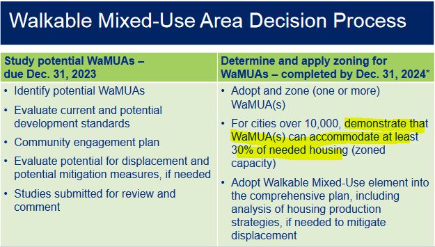
In any case, the new rules call for cities to "demonstrate that CFA/MaMUAs can accommodate at least 30% of needed housing."* (From the slide at top.)
In new memos they recently published the City has started the process to demonstrate complicance.
- Technical Memo #1, Housing Need
- Technical Memo #2, Draft Candidate Climate Friendly Areas (Walkable, Mixed-use Areas)
- Technical Memo #5, Dwelling Unit Capacity
Arguing with a Max Use Scenario
The City appears to be focusing on downtown and close-in West Salem. Last month's slide showed the "focus on mixed-use areas" for approximately 26,000 residences.
 |
| 26,000 residences in mixed-use areas (February online meeting slides) |
Back in 2012 the City published a Master Plan for the Minto bridge and path. They argued for "up to 21,700 non-automobile commuters" using the path system. Even though the "up to" formula rendered it technically true, the statement was nuts. As a truthful statement it met the letter, but not at all the spirit.
 |
| Not at all a plausible forecast from 2012 |
With the CFA/WaMUA analysis, the City and our Council of Governments/MPO is engaging in a similarly inflated claim and argument. The City is literally proposing to say it is reasonable and plausible to add nearly 20,000 residences downtown, and nearly 10,000 residences in close-in West Salem by 2035. That is 12 years away.
 |
| Max capacity for downtown and West Salem? (This is a composite from the technical memos) |
It's all an "up to" formula that meets the letter, but again violates the spirit. This is not a very helpful estimate or forecast. Its aim is to ensure Salem doesn't have to do anything more on climate.
The project at the former Nordstrom is for five stories and 157 residences. The Nishioka building is six stories and 148 residences. So for a rough estimate we'll use a mid-rise building on a quarter of a city block, with six stories and 150 homes as typical.
 |
| To build 10 per year for 13 years consecutively??? (Koz on State) |
To get 20,000 new homes downtown would require 133 new six story buildings with 150 homes in each. To do that by 2035 would be a little more than building ten per year. That's redevelopment of a full 2.5 city blocks per year. The UGM/Saffron site is basically one full city block. So that is actually redeveloping 2.5 of those every year. Every year.
To get 10,000 new homes in close-in West Salem would require 67 new six story buildings with 150 homes in each, building a little more than five per year.
Maybe midrise development would require too much wholesale demolition, a modern instance of bulldozing everything for "urban renewal"?
So then we are looking at towers. Is Salem ready for towers? Seems very unlikely.
On this reading, at the moment the City appears to be positioning the new Climate Friendly Areas/Walkable Mixed Use Areas for spectacular failure.
The idea is not to designate areas for wholly theoretical homes, homes on paper, but to designate areas for actual homes. That means realistic, plausible estimates. Not total fiction.
Above all, the discussion is not advanced by an analysis of some theoretical carrying capacity in which we max out everything, including demolishing our downtown historic district. But the City has embraced this approach as a dodge: "it was expected that CFA compliance could be met with the city’s current standards." (Technical memo 5)
The City is saying we don't need to do anything more.
A More Dispersed Approach is Needed
The City should instead to disperse much more the designation of formal Climate Friendly Areas/Walkable Mixed Use Areas and to have many more of them. Then each area will have a smaller total goal, a goal that is actually reasonable and plausible.
Downtown can still be a core CFA. 2000 new homes in downtown by 2035? That's one or two midrise buildings of 150 residences per year every year. That's aggressive, but also possible and plausible. It could even be exceeded with the right policy mix. Maybe 2000 is even a little small for downtown.
 |
| Much of the proposed change is for arterial corridors Our Salem map |
Too much concentration is the same problem we had in Our Salem with designating arterial corridors for new mixed-use zoning.
- "Our Salem Vision and Draft Plan Relies too Much on Arterial Conversion to Mixed-Use" (2020)
- "Problems with Seattle's Urban Villages might Prompt more Thought on Our Salem" (2021)
"Salem in Motion," our process to update the TSP, just looks confused right now. This first phase anyway is very definitely "Salem in Place," very stationary, an extension of Our Salem and a set of new land use policy changes. It's not at all a TSP update. That complicates the messaging.
It also appears to be embracing a set of goals that might meet the new State regulations technically, but are unlikely to achieve any actual goals for new housing and less driving. It's a Potemkin kind of compliance. This also confuses more than clarifies.
The City should retreat, reassess, and reformulate.
* In the phrase "needed housing" there may be some slippage, and certainly for non-specialist audiences there is a lack of clarity.
The target number of housing to be accommodated with the designation of CFA(s) is specified in OAR 660-012-0315(1): “... designate climate friendly areas sufficient to accommodate at least 30 percent of the total identified number of housing units necessary to meet all current and future housing needs”.
The adjectives on "housing need" are unclear. I see at least three meanings:
- Current
population and the housing need to house that population. Since we have
a housing shortage, there is still a future housing need under current
conditions and population.
- A current forecast for future
population and future housing need. This is a future housing need for
people not yet here, but which we have forecasted and expect.
- Some future TBD forecast for population and housing need. This is from some unknown future forecast not yet conducted, and not yet included in our expectations.
As I read these memos and discussion, it is not often clear about what the numbers actually represent.
A "target" of 19,638 residences in the downtown area needs greater specificity. How many residences are already there? Is this number only new residences or a sum of current and future residences. The unreality of the max case argument makes things extra slippery.


9 comments:
Re: "Downtown and the urban core area of West Salem are an extremely logical area to build up because it has a significant amount of very poorly used land (i.e. surface parking lots, pretty good sidewalk infrastructure, transit, and benefits from urban renewal funds, which is not the case in the other areas studied. How can you argue that's a bad thing?"
Where is there any argument here that building up downtown is a bad thing? You misconstrue and are strawmanning!
The argument here is that the City should be developing a plausible plan for CFA/WaMUAs with 30% of needed housing, a plan we agree might actually happen.
The City is instead offering a wildly implausible plan that meets the letter of the law, but which I think you would agree is nearly impossible to happen. (If you think this is a plausible plan, you should say more!)
Re: "We can't achieve density and the program's goals by scattering small increments of walkability widely throughout the City. That creates islands, not networks." Using "disperse" might not have been the best choice of words, but again, I think you misconstrue what a more distributed pattern of walkable development might look like.
You say "all of this change will depend on the private sector for financing and construction. We do not have a shortage of vacant or poorly used land; we have a shortage of market demand." We broadly agree on this! And that is why it has been argued here from the start, that the zoning changes have been concentrated on not enough land. If 5% of lots transition with redevelopment every year, the difference between 1000 and 100 eligible lots is the difference between 50 and 5 lots redeveloping. This is why here, as with the notes about restricting rezoning to arterial corridors, we have argued for broader, more distributed change. The more places that are eligible for change, the more likely we are to hit our targets.
As someone who has closely followed LCDC's CFEC work for the last two years, let me say that the SBOB critique of COG and the city's CFA capacity analysis is spot on. LCDC rules allow the city to make more reasonable and realistic assumptions than the city and COG chose to use. 1000 Friends and I wrote Salem and other metropolitan cities in January advising them of flaws in DLCDs so-called prescriptive method and encouraged them to choose the option of using local data, existing plans and local judgement to estimate the capacity of potential CFAs. It's telling and disappointing that staff have chosen not to provide information about (1) how much housing is currently in proposed CFAs or (2) that is called for in adopted local plans. Providing this information would illustrate how far-fetched the draft capacity analysis is. For example, a rough look at census data and city plans shows that downtown Salem has about 1000 housing units now and is expected to get another 1000 or so in the next 25 years. So under current plans we're expecting that there would be about 2,000 housing units downtown. While there is - as SBOB suggests - potential for more like 4000 or 5000, that's far short of the 20,000 the city suggests is possible. It's important to keep in mind that the goal of the CFEC rules is to actually get 30% of the city's housing in CFAs in the next 25 years. That will require a major shift in where and how we plan for and invest in housing, but it starts with getting an adequate and accurate amount of land designated for CFA-type. development.
Bob, can you call me at (202) 425-5493.
I think it's important that the Planning Commission get copies of letters sent to the city so we can ask questions and make this part of the public record.
Mea culpa. I have deleted my original comments.
Thank you for bringing to attention the City’s approach to the State’s climate friendly areas rule. Thank you, too, to Bob Cortright for his comment to your post but also for appearing at the last night’s Planning Commission meeting. Bob’s comments and the response from the city’s Planning Administrator, Lisa Ogilvy-Anderson were very helpful.
My original response to your post, in which you suggest that the city is following the letter but the not spirit of the rule, was disagreement. I retracted that until I heard more from Bob and had a chance to read the rule and related material and do so more research. After review, I am more confident that your assessment is off base. Here’s why.
The criteria for climate friendly areas for cities with more than 50,000 people is: at least 25 acres, at least 750 feet in width, already high density, near reliable transit, and having short blocks. The state suggests downtowns, shopping corridors, and transit centers. These climate-friendly areas must require 25 residents per acre and no maximum, and an allowable building height of no less than 85 feet. With downtown, north of downtown, and West Salem, the City is on track to designate about 500 acres as primary climate friendly areas. That’s 20 times the minimum requirement.
I expect you will point out that the City must not just project these that areas have the capacity to capture 30 percent of our housing needs (about 25,000 units) but do, in fact, capture that percentage or more. Yes. That’s true. And, as you detail in your post, it’s hard to believe there will be enough development in those three areas to provide 25,000 units. I think so, too. But that is not because there is not sufficient land there, it is because 25 residents per acre is highly ambitious given the market. Salem will need a whole different class of developers from what we’ve had in the past. We have very few developers with experience building mixed use buildings or buildings over 4 stories. Also, the price per square feet rises with height, which means the rental or purchase costs will be higher for the customer and a riskier investment for the developer.
More importantly though, you are not taking into account, or have decided to discount, all of the mixed use zoning the City created as part of Our Salem. The State rule allows cities over 50,000 residents to designate secondary climate friendly areas. These areas must be zoned to allow 15 residents per acre, an allowable building height of at least 50 feet, may be less than twenty-five acres, but must still be at least 750 wide, and have (or planned to have) good pedestrian/bike infrastructure. I spent several hours reviewing the zooning map and found 8 areas that meet those requirements. Four on Commercial, one on Lancaster, one immediately east of the Capitol Mall, one on Fairground Road, and one on Hawthorne. These total and additional 830 acres. In other words, the city has already created exactly what you are asking it to do regardless of the land’s “official” designation.
One final note. You wrote: Maybe to avoid politics of the word "climate," the City is attempting to rebrand them as "Walkable Mixed-use Areas." The State’s implementation guide offered this “tip” in a callout box: “Local governments do not have to use the term “Climate-Friendly Areas” in their plans. The intention of the rules is to build off of and enhance existing planning for compact mixed-use development. Naming conventions of zoning and branding and the work effort is up to each jurisdiction to decide.” I don’t think it’s a fair to assert that the City is trying to avoid the politics of climate because it is using a different name.
We can certainly agree to disagree, but name calling readers who take your writing seriously enough to investigate does not show you at your best.
[Comment moderation note and repost. Mike Slater protests that we've violated our own commenting guidelines, and the criticism is fair. Here's a revised comment to replace the deleted one.]
Since there will be other documents, other meetings, other milestones, all of which will be occasions for further comment, it will be better to return to the debate that way, and we'll pick up the threads then. Trying to hash it out in long comment threads gets tedious.
So only one comment for now: If the areas, "Four on Commercial, one on Lancaster, one immediately east of the Capitol Mall, one on Fairground Road, and one on Hawthorne," should be designated CFA/WaMUAs, the City should do so explicitly and not dance around that, counting them when it is convenient and excluding them in other contexts when it is convenient.
Post a Comment