Showing posts with label Mays Landing. Show all posts

Monday, May 16, 2016

Commercial Vista Corridor Study Back from Dormancy, at Planning Commission Tuesday

Normally personnel isn't a topic here, but last summer you may have noticed that Judith Johnduff left the City's transportation planning group. This impacted staffing for the Commercial Vista Corridor Study, and it went a little quiet.

Final report cover

But the Study is back, and will be at the Planning Commission tomorrow with an informational presentation on what looks like the final report.

It may be necessary to revisit this later this week, but at the moment it doesn't look there are any major changes - but it does look a little smaller, like it has been dialed back some to be more modest in totality, and it may be useful to compare the final recommendations to the draft ones in finer detail.

The big things strike me as still being retained.

There's the buffered bike lanes for Commercial.

Buffered bike lanes on Commercial
(yellow highlighting added)
The crossing and continuation for south-bound bicycling on Commercial at the "dysfunction junction" with Liberty is retained.

Friday, March 25, 2016

City Council, March 28th - Portland Road Action Plan

Council meets on Monday, and there's not a lot to say here about the agenda.

Probably the most interesting thing is a formal report and authorization for action on the Portland Road study, but the presentation has nothing new. (See previous discussions here.)

Still, the slides on the near-term projects are simple, clear, and hit the right notes...


Monday, February 8, 2016

Third Try May not be the Charm for Proposed May's Landing Apartments

On Wednesday what is, I think, the third main iteration of a proposed May's Landing development south of Mission Street on 23rd is at the Hearings Officer.

Current proposed site plan - Staff Report
The project looks like a cookie-cutter development for 96 apartment units in six building blocks.

SENSA barely endorsed it by a deeply mixed 5-4 vote, and the Staff Report recommends denial, saying it hasn't sufficient addressed concerns formalized in Council's last decision on the second iteration.

Staff Summary
In 2012 Council identified issues with
  • Compatibility with surrounding uses
  • Walking safety and comfort
  • A lack of schools and parks here
  • Neighborhood traffic concerns on Oxford
  • Industrial-grade noise from the Airport and City Shops
No matter how you slice it, the current proposal it looks suboptimal and problematic.

Thursday, January 21, 2016

At the Hearings Officer: A Bed and Breakfast on Chemeketa, May's Landing

1811 Chemeketa St. NE
1905 Birdseye Map of Salem
via Library of Congress
While this item has some neighborhood significance, it has no real significance for transportation or anything else, and this is just a note about a favorite house and intersection in Salem. But it is funny how much anxiety is occasioned by the matter of parking on the public space we call a street.

The Daniel S. Yoder house of 1891 is insanely cute. It is a gable-front with a little tiny wing and sits in an elbow of Mill Creek at the corner of 18th and Chemeketa. There are two bridges by it. It's almost Kinkadian. (But for real!)

Kitty-corner is the Samuel Hughes house of 1908.

The intersection jogs and is clearly a seam between two plats. It has charm and character and energy. If your walks and rides don't take you by it at all, when the trees are in bloom you should arrange a spring walk through the Court-Chemeketa Historic District and check it out.

Some new owners wish to turn it into a Bed and Breakfast, and so next week the Hearings Officer will decide on a Conditional Use Permit to go from residential to the B&B. Interestingly, the lot is zoned Residential Duplex.

The Staff Report recommends approval with conditions.

Most of them are about micro-managing parking!

May's Landing is Back

More substantive and directly relevant is the return of the May's Landing project.

Just south of Mission on 23rd
The City just posted a Hearing notice for a proposed 96-unit apartment complex at this site on 23rd Street south of Mission Street.

It will be interesting to see how the proposal has changed from previous iterations and how walkable it may or may not be. You can see from the aerial how much surface parking and industry there is here. Mission Street is wide and fast and inhospitable here also. It's probably a cookie-cutter autoist thing, but you never know - and we can always hope.

Wednesday, August 14, 2013

Proposed May's Landing Apartment Complex Back at City; Units Reduced, Still Not Recommended

Tonight the Hearings Officer will deliberate on a site plan review, conditional use permit, and design review of a proposed 54-unit apartment complex located just south of Mission and 23rd.

Last summer a much larger complex was proposed and ultimately Council redirected the developer.

It's back, and the Staff Report notes some of the changes, while also not recommending approval:
The request includes a reduced number of dwelling units from the January 2012 proposal from 96 to 54, and includes a non-residential office building. Access to Oxford Street SE is not proposed with this application.

Staff recommends that the Hearings Officer DENY the request...
Mission Street here is a State Highway, and it is so auto-oriented.  This is not a good place for a traditional auto-oriented housing development.  It's also by the airport, and both the neighborhood association and the airport/FAA have concerns about the site's fitness for more residential housing.   The neighborhood lacks a grocery store also. 


Notice the person on bike going opposite traffic (they're on the sidewalk, though, not in the bike lane) and the right-in, right-out treatments for 23rd, the cross street. There's really nothing multi-modal about this road. It's a highway.  (It's a stroad!)

If we want to create higher density housing in lower-car and more walkable configurations, this is not a good project yet.  The neighborhood association feels development at this site should be more commercial or industrial and not primarily residential.  At the very least it should have some kind of mixed-uses - not more of the same.

Saturday, August 25, 2012

City Council, August 27th - Minto Design, Missed Opportunities

September 10th will be the continuation for the Bike and Walk Salem hearing. 

In the mean time, rain and river lead the agenda for Monday.

Though it's been out for a few weeks, and is not itself on the agenda for Council, a couple of renderings of the Minto bridge design are just hitting the news. (Maybe there's unannounced grant funding news?)

Via City of Salem and Greenworks
On the Urban Renewal agency agenda is $30,000 for design work on the path on the Minto side.

January 2012 Flood
Across the river in Wallace Marine Park, there's a proposal for a rain garden by the bathroom.

For the garden, the Glenn and Gibson Creeks Watershed Council propose additional "Interpretive signage,"which "will help visitors understand the role of stormwater, the purpose of rain gardens and the Willamette River ecosystem."

Speaking of the flood, Council proper will receive an information report on flood damages and repairs. The projected total looks like $8.5 million. FEMA's reimbursed almost a quarter million so far. The big-ticket item is repair of the Winter Street bridge over Shelton Ditch, and that's estimated to cost $3.6M, for which FEMA will reimburse 90%.  A temporary fix has allowed the bridge to be reopened, but the major, structural repairs are yet to come.

Wednesday, June 27, 2012

Hearing on Proposed Apartments on 23rd Shows Limits in Comprehensive Plan

Tonight the Hearing Officer will deliberate on a site plan review, conditional use permit, and design review of a proposed 96-unit apartment complex located just south of Mission and 23rd.

Some thoughts on it are here.

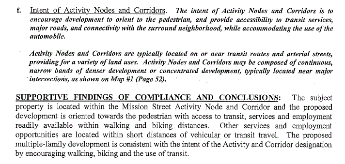
The part I want to zero in on is a criterion in the Comprehensive Plan for the conditional use permit.

The idea that this location is good for walking and biking is ludicrous, but the way our plans and zoning are written, the mere fact of sidewalks and bike lanes necessarily implies these will support trips other than drive-alone car trips. This is not pedestrian oriented!

The particular criteria and interpretive standards by which we seek to instantiate higher level goals are incoherent with those higher level goals. The way Mission is currently built, and the way we are placing car-dependent development along it, will not provide anyone with meaningful alternatives to drive-alone trips.

After the Bike Plan update, there's work to do on the Comprehensive Plan and other zoning stuff.  (And there's got to be a way to make it simpler - this is so Byzantine!)

Update, July 19th

I don't know why I didn't think of this before - but Mission here is also a State Highway:

Notice the person on bike going opposite traffic (they're on the sidewalk, though, not in the bike lane) and the right-in, right-out treatments for 23rd, the cross street. There's really nothing multi-modal about this road. It's a highway.

Saturday, June 9, 2012

Proposed Apartments on 23rd, South of Mission, Tricky for Food and Transport

Recently the City announced a hearing for a site plan review, conditional use permit, and design review of a 96-unit apartment complex located just south of Mission and 23rd.

At first glance it's a little bit of a head-scratcher. The area is bounded by the railroad, McGilchrist, 25th, and Mission. The airport and industry dominate. City Public Works shops are nearby.

But there's a residential pocket to the south, small homes orphaned by other development around it. Unlike a lot of development on the edges of the city, even with the industry, this is, well, central-ish. It should be easy to get places.