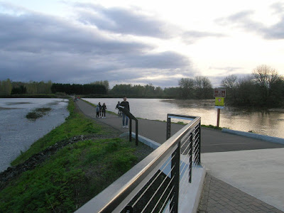
But with the river now projected to rise to about 27 feet - edging towards 2012 levels, but many feet short of 1996 or 1964 - we may get to see the path covered.
 |
| "Closed"? What does that mean?! (yesterday evening) |
- "The Proposed Minto Bridge in Floodtime" (2012)
- "Flooded Minto Bridge and Path Route Surveyed" (2012)
- "The Minto Bridge would have Closed this Weekend" (2014)
- "So What about the Minto Bridge in High Water?" (2015)
 |
| Around 24 feet on Tuesday, cresting near 26 feet But it's been updated to nearer 27 feet for tomorrow - via NOAA |
We may get to find out!
 |
| The water's getting close to the bridge... (again, photos from yesterday evening, at about 24 feet) |
 |
| With the river at 24 feet, it's still got another two or maybe three feet before it covers the path |
And only when the City was making exaggerated claims for the trail as a "commute corridor" was this interesting. Intermittent closure from high water does not really diminish the value of the bridge and path system as they are actually used. People are using the bridge for recreation, usually doing loops from a parking lot, not through travel, and it is no great problem when bad weather hampers that recreation. People adjust.
So this is just trivia. Maybe today or tomorrow the path will be covered and we will see the answer.
Update, April 11th
Yes, the path has flooded!
 |
| At midday the river was at about 27 feet, and water covered a good length of the path |


1 comment:
Updated with new photo and link to longer discussion of the path's submergence.
Post a Comment