 |
| (click to enlarge) |
 |
| (click to enlarge) |
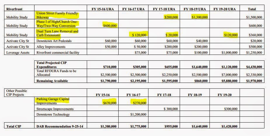
- Starting in 2017-18 the Board recommends that there be no more subsidy for capital expenses on the parking garages downtown. The subsidy will taper, and the allocation for 2016-17 will be less than half of the usual amount. This is likely to hasten a longer-term solution to the problem of funding downtown parking.
- In addition to the light and other improvements at Union and Commercial, the DAB is recommending work, principally striping bike lanes, on the High/Church couplet as well as eliminating several sets of dual-turn lanes. (Though the notes say "Union Street Family-Friendly Bikeway" and "High/Church One-Way/Two-Way Conversion" both labels are a bit misleading. The preliminary steps would involve paint and striping only, and still leave the real family-friendly and two-way conversions for later. See here for more on the Union Street details.)
- There's also a cryptic allocation for a "Riverfront commercial facility." It's from the Downtown Strategic Action Plan and is still more general concept than detailed proposal or plan.
 |
| (click to enlarge) |
That's real progress - though of course so much more is possible!
Meeting agenda and packet is here.
The Board meets Thursday, October 23rd, from 12:00 pm – 1:30 pm in the Kalapuya Conference Room, 295 Church Street, Ste 201.
EOA-HNA - Too many 20th Century Assumptions!
The draft reports are out on the EOA-HNA and the advisory committee also meets on Thursday:
- Draft Housing Analysis
- Draft Economic Analysis
- Draft Housing Implementation Strategy
- Draft Economic Implementation Strategy
 |
| Yeah, sometimes you can judge a book by its cover. |
(Oh wait. That's like this post maybe. Regardless, the reports need more pretty pictures! In the meantime, here's a musical interlude...
Back to the regular programming...)
If there is a high-level criticism, it's that climate change isn't discussed in housing, and in the jobs study it's relegated to an appendix - and even there it's mostly in the footnotes. Climate change is noted, but doesn't call for any actions. It's a potential wrinkle, not a transformative event that summons our highest creativity and power.
 |
| Climate Change: There's a consensus, but we're not actually going to factor it into our analysis or try to do anything about it. |
Overall, the thing feels yet bound by assumptions and methods from the last century. It's not a real leap into the 21st century and what jobs and housing are going to look like in another generation.
It is striking that Sightline yesterday cited a brand-new State of Washington set of traffic projections.
 |
| via Washington State Ferries Transportation Revenue Forecast, October 2014 (Sightline link broken) |
 |
| Between McGilchrist and Madrona are lots of fallow land |
 |
| Sizable undeveloped orchard land off of Ewald |
The studies look like an incremental improvement, but they call for additional task forces, studies, and zoning changes; and they still look bound to 20th century assumptions rather than to likely 21st century conditions.
Have you read them? Maybe you have a different take?
The EOA-HNA meets Thursday the 23rd at 5:30pm, in Pringle Hall, 606 Church Street SE.
Update, October 29th
Here's a note from a couple of days ago.
 |
| Time limits are working! |


6 comments:
It's good to see some positive changes planned for downtown, after the disastrous intersection widening in West Salem and all the third bridge planning...
What is your opinion of the annexations on the ballot in Salem/annexations in general?
Annexations? Ha! They baffle me. Here's a little bit of previous discussion in this post and an older one. (I wish someone else would write about them!) It is strange that there's all this development that is enjoying substantial slices of city life and services, but yet it would cost so much to upgrade it to city standards. It seems wasteful not to have them inside the city, and it seems wasteful to bring them into the city. There may not be a good solution.
I know the annexation in east Salem. It is a person who wants to build a tri-plex on a lot that with RS would only allow a duplex. So, he is asking for a change to RM. It is next to a mobile home park, so the density is not much of an issue. What is kind of not good about it is that the street is narrow and allows only parking on one side of the street. With the higher densiity my guess is that people will park on the street and there will be an enforcement issue.
These small parcels in the edge eof town are often annexing because they need water. In east Salem the city has a policy not to allow wells or go on East Salem Water District if they are on the boundary. This is to force annexation gradually.
We are likely to see fewer annexations because the City went through a process the last 4 years to get significant amount of land annexed on the boundaries of Salem. They looked at the issue of large annexations, but decided that the cost to bring them up ot city standards would not be covered by the taxes gained.
To remedy this the City has tried to impose a requirement that property within the UGB but in county, adhere to the same development standards. I am not sure they are 100 percent equal yet as Marion County allows much more dense developments with narrower streets....or at least they did.
East Salem Water District has a lot of substandard utilities as well. You mention the donut holes in our street systems caused by past annexations. This situation never got fixed even though this was a promise made by the City Council when the vote was being taken back in the 60's. Not only are the streets substandard, but also the water lines and drainage systems. I know that in some areas the Fire Chief has claimed that a large fire like at a church or school could be hampered by the fact that the water lines are too small. Thus, they require them to have extra fire surpression systems built in and even then might have to cut service to surrounding homes while the fire is happening.
To clarify, the donut hole iI was referring to s in South Salem, not east Salem. I imagine there are substandard areas in that area too, but I was making the point that the City has a history of not addressing these issues even with the new tax base, because it is not enough to actually do the work.
Thanks, Susann! That's helpful info and commentary!
Really, it seems like the solution is: If you want city-style development at normal suburban city densities, and to enjoy the benefits of being adjacent to a city and its services, you have to accept city-level taxes. Maybe there should be no land inside the Urban Growth Boundary that is also outside of a city? Trying for uniform development standards seems like a reasonable step in the right direction.
(Also, it's possible skinny streets are a feature rather than bug!)
(Sightline VMT graphic broken, so updated with link to WashDOT source document.)
Post a Comment